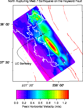
The simulation may be used to produce a map of peak horizontal strong ground shaking. The following map shows the distribution of peak horizontal ground velocity in units of meters per second. The location of UC Berkeley is shown by the arrow. Several stations of the Berkeley Digital Seismic Network (BDSN) operated by the Berkeley Seismological Laboratory are shown as inverted triangles. Because of the northward direction of rupture there is tremendous focusing of waves which is evident by the very large near fault ground motions exceeding 1 meter per second along the northern part of fault. The ground motions decay rapidly north of the end of the fault, but on the Berkeley Campus the estimated ground motions are on the order of 0.60 meters per second. Accelerations of between 20 to 30% of the acceleration of gravity are predicted for this particular earthquake rupture scenario.

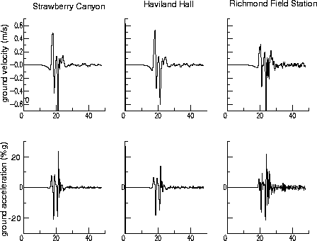
Seismograms simulated at the BDSN sites in Stawberry
Canyon, at Haviland Hall and at the Richmond Field station. The Richmond
Field Station site shows high frequency ground motions and the simulated
acceleration is greater than what is simulated at the two campus sites,
even though it is nearly 15 km further from the earthquake. This amplification
is due to the relatively softer sedimentary materials beneath the site.