MIN - Mt. Lassen Park Headquarters, Mineral, CA, USA
We operate broadband and borehole stations under the network code BK. The Berkeley Digital Seismic Network (BDSN) is a regional network of very broadband and strong motion seismic stations designed to monitor regional seismic activity as well as provide high quality data. The Berkeley borehole stations have borehole geophones or other seismic sensors and may have other geophysical instrumentation.
| Station Name | MIN |
| In Operation | 1993/03/19 19:46:00 - 1999/12/08 18:10:00 |
| Latitude | |
| Longitude: | |
| Elevation: | 1470.9 meters |
| Instrumentation | Broadband |
Location
Site is located in Lassen Volcanic National Park, Mineral, California. The instruments were relocated to station MOD in late 1999 due to increasing noise.The MIN site was first occupied in 1938, with the installation of Wood-Anderson seismographs.
Network
Berkeley Digital Seismic Network (BK)Geology
Pliocene Volcanic Debris
Borehole Conditions
The instruments are sited in a wooden frame building constructed as a WPA project (circa 1935) for the installation of Wood-Anderson torsion seismometers. The hillside building is partially underground and unheated. The concrete pier is located in the same room as the datalogger and supporting equipment. The seismometers are thermally insulated with 4" of polyurethane foam.Station Pictures
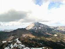
View of Mt. Lassen |
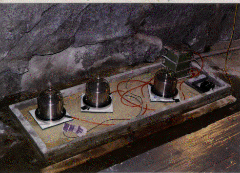
Typical STS-1 installation |
Table of Seismic Instrumentation
| Sensor | Datalogger | SEED Channels | Location | |
| Broadband | Streckeisen STS-1 VBB Feedback Horizontal Seismometer | Q935 | BH?,HH?,LH?,UH?,VH? | |
| Streckeisen STS-1 VBB Feedback Vertical Seismometer | Q935 | BH?,HH?,LH?,UH?,VH? | ||
| Accelerometer | Kinemetrics FBA-23 Accel. (2 g max 1.25 v/g) | Q935 | BL?,HL?,LL? |
Waveforms and associated metadata are available at the Northern California Earthquake Data Center (NCEDC).
Waveform Data
- BK Information Directory, including
- List of station locations
- List of available channels
- Instrument Response
- Querying the archives
- Download waveform data

