Seismo Blog
Contortions in the Sierra Nevada
Categories: California | Nevada
January 25, 2013

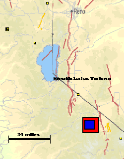
There were two sizable earthquakes just south of Lake Tahoe in the Sierra Nevada Mountains within 24 hours of each other. They are represented as the two blue squares. Click to view a larger image.
By California standards the Sierra Nevada cannot be considered a seismically very active region. After all, no plate boundary defining fault, like the San Andreas, runs through it. But two earthquakes, one with a magnitude of 4.0, the other a 3.7, which occurred within less than 24 hours and within a few hundred feet of each other are a stark reminder that our famous granitic range is by no means geologically dead. The two quakes occurred in an uninhabited area halfway between Lake Tahoe and Mono Lake just southwest of the point where Highways 89 and 395 meet. The first one jolted the region 21 minutes after midnight on Thursday, the second one occurred about 15 hours later. More than a dozen very small aftershocks were recorded in the intervening time.
Geologically speaking, the Sierra Nevada is a very young mountain range. Its granitic core is a pluton, which was originally a giant blob of magma that eons ago rose from the Earth's interior but never reached the surface. Instead, it got stuck in the Earth's crust, where the magma slowly cooled. Several million years ago, long after the magma had frozen into solid granite, some forces from below pushed this pluton slowly upwards. It began to rise above the surrounding landscape until it reached an elevation of almost three miles. Then erosion slowly began to raze the tops. Still, with Mount Whitney as the highest peak in the conterminous United States, the Sierras are an impressive range.
The uplifting of the pluton, however, did not occur evenly, because its eastern section rose much faster than the western part. The result is a strongly tilted mountain range. This tilt can still be seen today. When you drive east on highway 120 through Yosemite it takes hours before you reach the high point at Tioga Pass. But beyond the culmination, you drop down into Mono Lake Basin within a few dozen minutes while the road hugs some very steep cliffs.
The asymmetry of the upward movement also had other consequences. Along its eastern front a major thrust fault developed, which still causes earthquakes in the Owens Valley (refer to blog October 5th, 2009). In addition, volcanoes erupted during the pluton's uplift. The Long Valley Caldera as well as the Mono and Inyo Craters are clear examples of this volcanism. The youngest of these craters are only 500 to 600 years old - a mere blink of the eye on the geological time scale. And in the Long Valley Caldera near the town of Mammoth Lakes, hot springs and earthquakes are a reminder of its violent past. However, the volcanism is confined to a narrow zone along the eastern margin of the Sierras.
If volcanoes and the thrust fault reign only in the eastern section, how then, you may ask, are earthquakes generated in the rest of this vast, sturdy-looking range? The answer is actually pretty simple: Because the tectonic uplift of the massive pluton was so uneven, it was twisted and bent during its journey. These internal contortions set many parts of the pluton under mechanical stress. It is released today, after millions of years, through earthquakes like the ones which occurred on Thursday. (hra084)
BSL Blogging Team: Who we are
Recent Posts
-
: Alerts for the Whole West Coast
-
: Destruction in the Eastern Aegean Sea
-
: An Explosion in Beirut heard all over the Middle East
View Posts By Location
Categories
- Alaska (3)
- Bay Area (24)
- Buildings (3)
- Calaveras (4)
- California (13)
- California ShakeOut (3)
- Central California (4)
- Chile (4)
- Earthquake Early Warning (10)
- Earthquake Faults and Faulting (44)
- Earthquake Science (3)
- Haiti (3)
- Hayward (12)
- Indonesia (4)
- Induced Seismicity (3)
- Instrumentation (18)
- Italy (6)
- Japan (7)
- MOBB (3)
- Mendocino Triple Junction (5)
- Mexico (7)
- Nepal (3)
- North Korea (5)
- Nuclear Test (5)
- Ocean Bottom Seismometer (3)
- Oklahoma (4)
- Plate Tectonics (18)
- Preparedness, Risks, and Hazards (16)
- Salton Sea (3)
- San Andreas Fault (14)
- Seismic Waves (13)
- Seismograms (4)
- ShakeAlert (3)
- Southern California (5)
- Surface Waves (3)
- Today in Earthquake History (20)
- Volcanoes (4)
- subduction (3)