Grant 1434-HQ-99-GR-0066
Roland Bürgmann, University of California, Berkeley
Department of Geology and Geophysics
389 McCone Hall
Berkeley, CA 94720-4767
Telephone: (510) 643-9545; FAX (510) 643-9980;
URL:
http://www.seismo.berkeley.edu/~burgmannNEHRP Program Element: II, Evaluating Earthquake Potential
Keywords: Surface Deformation, Geodesy, GPS-Campaign
The southern Bay Area is a structurally complex region of the North American-Pacific plate margin. The dominant tectonic feature of the region is the San Andreas fault (SAF) system, which accomodates most of the slip associated with the transform plate margin. Geodetic measurements reveal a spatially complex deformation field with evidence for time-dependent strain that may affect the timing of future earthquakes in the Bay Area. Although the general nature of the plate boundary (right-lateral strike-slip distributed between the major strike-slip faults with small amounts of contraction) is relatively unambiguous, several specific areas exhibit behavior that suggests structural complexities that may relate to earthquake hazards.
Since the 1989 Loma Prieta earthquake, we have performed repeated Global Positioning System (GPS) surveys and found significant differences between the active displacement field and that measured in the preceding two decades using Electronic Distance Measuring (EDM). The pattern of deformation suggests significant postseismic contraction across the youthful southern Santa Cruz Mountains northeast of the SAF. We monitor the details of anomalous post-seismic strain pattern by continuing to collect geodetic data from the southern Bay Area GPS network. Our own measurements are complemented by GPS data collected by the U.S.G.S. crustal deformation group. We are now also including interferometric synthetic aperture radar (InSAR) data in our analysis of the regional strain field.
This project provides the best record to date of anomalous postseismic motions and their effects on neighboring seismogenic faults. Mechanical models based on these geodetic constraints suggest that postseismic processes play an important role in the development of temporally and spatially clustered earthquakes. The ongoing geodetic studies allow us to estimate the current strain rates throughout the SAF system, estimate fault slip rates, determine the contribution of aseismic fault creep, and evaluate elastic strain accumulation in areas that may present a seismic hazard.
The primary objective of this project is to monitor the spatially and temporally complex active deformation field in the southern Bay Area. This report will focus on two aspects of this investigation:
Data. The southern San Francisco Bay Area GPS network consists of several profiles across the SAF system and additional arrays localized around areas of particular interest. The Black Mountain, Loma Prieta, and Monterey profiles are part of a larger network established by the U.S. Geological Survey that consists of six GPS profiles across the SAF system and the 5-station Loma Prieta Monitor network. To improve the spatial resolution of the displacement field following the Loma Prieta event, we yearly reobserve a 22-station GPS network (Santa Cruz Mountains network) near the epicenter. We have also densified our occupations in the Pajaro region at the transition region to the creeping San Andreas fault segment, along the Calaveras fault, and surrounding the Hayward fault.
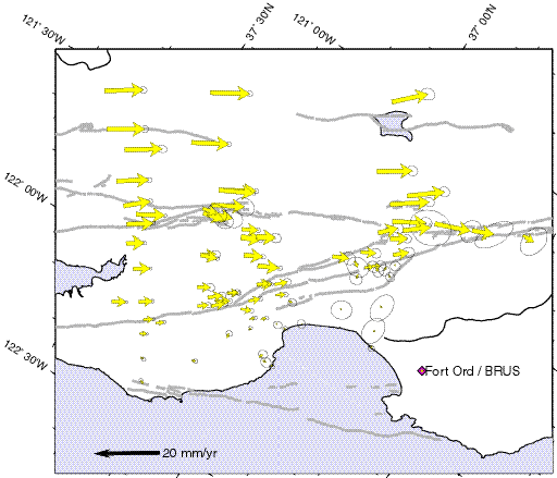
GPS data from the southern Bay Area have been processed using the Bernese GPS processing software (Version 4) developed at the University of Bern. Continuous data collected through the BARD network are processed with campaign data collected for this project during the same time period. We combine the campaign data collected by the crustal deformation groups at Stanford University, the University of California, Berkeley, an d the USGS to compute the final velocity field shown in Figure 1. Figure 1 shows the GPS network that was monitored for long enough to produce reliable velocity estimates. We excluded data affected by the Loma Prieta postseismic transient to plot the secular motions shown in this figure.
|
|
Figure 1. GPS observations of secular deformation in the southern Bay Area
Station displacement field relative to the station BRUS (near Fort Ord) located west of the San Andreas fault. Ellipses indicate the 95% confidence range of the velocities. The post-seismic relaxation signal from the 1989 Loma Prieta Earthquake has been removed from the velocity field by excluding data of stations affected by the transient deformation from 1989 until 1994. The map is shown in an oblique Mercator projection about Pacific plate to Sierra Nevada - Great Valley block Euler rotation pole (D. Argus, pers. comm., 1998). Horizontal lines are parallel to small circles about the plate motion pole.
Time dependent fault slip following the Loma Prieta earthquake. The observed horizontal displacement rates within a radius of ~20 km from the epicenter of the Loma Prieta earthquake differed significantly from those measured in the two decades preceding the earthquake (Bürgmann et al., 1997a,b; Pollitz et al., 1998). The anomalous displacements consist of up to 8 mm/yr of accelerated right-lateral shear parallel to and centered on the SAF, averaged over the 1989-1994 time period. Additionally, we observe a zone of southwest-northeast contraction centered northeast of the Loma Prieta at rates exceeding 10 mm/yr. Horizontal site velocities in excess of the secular rates can be best explained by a dislocation model that includes a combination of aseismic reverse slip on a fault in the Foothills thrust belt northeast of the SAF and strike-slip on the SAF at relatively shallow depths (Bürgmann et al., 1997b).
We modeled the measured displacement field with rectangular displacement discontinuities for uniform slip in a homogeneous elastic half-space (Bürgmann et al., 1997b), or in an elastic layer above a viscous substrate (Pollitz et al., 1998). Since the sources of the measured post-Loma Prieta earthquake deformation are dominantly located in the upper crust and our measurements span only few years, elastic models are the best method for the study of the postseismic data. To generate the best-fitting model of the measured displacements, we utilized forward modeling procedures and inversion schemes. A non-linear quasi-Newton estimation approach allows the determination of the best-fitting geometric parameters (strike, dip, depth, etc.) of one or more uniform-slip dislocation planes (Bürgmann et al., 1997b). We evaluated models of the observed deformation that address the viscous component of crustal deformation, integrating the geometric complexity of the Bay area faults with more physically-based models of crustal deformation (Pollitz et al., 1998). In this analysis we found that only about 10-20% of the postseismic transients can be attributed to possible effects of viscous relaxation at depth.
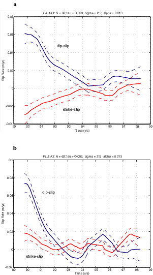
We developed inversions (Segall et al., 2000, JGR in press) for time dependant fault slip on the afterslip planes identified in Bürgmann et al. (1997b). We employ a modified version of the Network Inversion Filter (Segall and Matthews, 1995) to investigate time dependent slip following the 1989 Loma Prieta earthquake. Previous analysis of GPS and leveling data suggests afterslip on the Loma Prieta rupture as well as aseismic slip on a thrust fault northeast of the San Andreas fault which we identify with the Foothills Thrust belt. We analyzed 173 daily GPS solution files at 62 stations collected from 1989.8 to 1998.3 (a total of 1,134 3-dimensional relative baseline determinations). The observed position changes are assumed to result from secular deformation, random benchmark motions, and temporally varying fault slip. The data reveal temporal variations in slip-rate, but poorly resolve spatial variations in fault slip. The amount of temporal smoothing is estimated by Maximum Likelihood. Conditional on this estimate, reverse slip on the Foothills thrust decays from 74±11 mm/yr immediately after the earthquake to zero by sometime in 1992 (Figure 2). Reverse slip on the Loma Prieta rupture surface decays from 61 ± 11 mm/yr to zero by 1994. Right lateral slip on the Loma Prieta rupture surface decays monotonically from 29 ± 10 mm/yr to zero by 1994 (Figure 2). These results suggest that: (1) triggered afterslip can occur off the main rupture zone on adjacent faults, (2) shallow afterslip dominated the postseismic deformation for the 8 years following the earthquake, and (3) postseismic slip on the Foothills thrust may account for a significant portion of its total slip budget.
|
|
Figure 2. Time-dependent aseismic dip slip and strike slip following the 1989 Loma Prieta earthquake. The network inversion filter analysis identifies time dependent dip slip and strike slip on the buried rupture of the Loma Prieta earthquake (Fault #1) and thrusting on the segment of the Foothills Thrustbelt which experienced insignificant strike slip in the years following the event. (From Segall, Matthews, and Bürgmann, 1999, J. Geophys. Res., in press). |
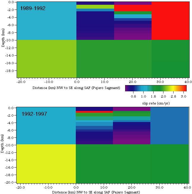
Complex behavior of the SAF near San Juan Bautista. In addition to a study of the post-seismic relaxation following the 1989 Loma Prieta earthquake, geodetic data is being used to model slip on the SAF near San Juan Bautista at the transition to mostly aseismic creep on the central SAF segment. We have densified our GPS observations in this region for the last several years, as this is an area where slip is accommodated both during moderate size earthquakes and by aseismic creep, sometimes in the form of slow earthquake events. The GPS data (Figure 1) are complemented by creepmeter data collected by the USGS along the SAF and by EDM data collected in the Pajaro network (Mueller and Johnston, 1997) and throughout the Bay Area before 1989 (Lisowski et al., 1991). The data are divided into several time periods; pre-1989 geodolite data, 1989-1992, 1992-1997, 1997-1999.
|
|
Figure 3. Preliminary inversions for distributed slip along the Pajaro segment of the SAF
The slip in the southeastern portion of the network is not well constrained due to the lack of GPS control in that area (Fig. 1). The most apparent preliminary result from these inversions is the larger amount of slip in the Pajaro-San Juan Bautista region (km 0-20) during the three years following the 1989 Loma Prieta earthquake.
We model slip on the fault as dislocations in an elastic, isotropic, homogeneous half-space. We apply constraints to the direction (right-lateral) of slip, and the magnitude of slip on neighboring fault segments of the SAF and East Bay fault systems. Surface creep rate measurements from creepmeters are included in addition to the GPS and EDM data constraints.
Our preliminary results (Figure 3) suggest that there was an episode of accelerated slip at depth below the Pajaro segment of the San Andreas fault, presumably triggered by stress changes during the earthquake (Wilber and Bürgmann, 1999). We are currently refining our model inversions and are testing the resolution power of these models. We are also comparing and integrating our results with additional constraints provided by repeat frequencies of identically repeating micro-earthquakes (in collaboration with R. Nadeau, Nadeau and McEvilly, 1999).
We use the Global Positioning System (GPS) to gather information on the crustal movement in the southern San Francisco Bay region. The velocities are then used to model the time-dependent postseismic relaxation in the region surrounding the rupture area of the 1989 Loma Prieta earthquake. The accelerated velocities are best explained model that includes a combination of rapidly decaying aseismic reverse slip on a fault in the Foothills thrust belt northeast of the San Andreas fault and less rapidly decaying strike-slip on the San Andreas fault at relatively shallow depths. Most of the transient deformation apparently ceased by about 1994, however, transient deformation anomalies apparently persist along the transition region to the creeping San Andreas fault.
Bürgmann, R., 1997, Active detachment faulting in the San Francisco Bay area?, Geology , v.25, p.1135-1138.
Bürgmann, R., Segall, P., Lisowski, M., and Svarc, J.L., 1997a, Strain development subsequent to the 1989 Loma Prieta earthquake, U.S.G.S. Professional Paper 1550D, p.209-244.
Bürgmann, R., Segall, P., Lisowski, M., and Svarc, J.L., 1997b, Postseismic Strain Following the 1989 Loma Prieta Earthquake From GPS and Leveling Measurements, Journal of Geophysical Research, v. 102, p.4933-4955.
Gross, S., and Bürgmann, R., 1998, Rate and state of background stress estimated from the aftershocks of the 1989 Loma Prieta, California, earthquake, J. Geophys. Res., v. 103, p. 4915-4927.
Pollitz, F., Bürgmann, R., and Segall, P., 1998, Joint estimation of afterslip rate and postseismic relaxation following the 1989 Loma Prieta earthquake, J. Geophys. Res., v. 103, p. 26,975-26,992.
Segall, P., P. Cervelli, M.H. Murray, S. Owen, and R. Bürgmann, 1998, Imaging slow seismic sources using GPS, Seismol. Res. Lett., 69 (2), 145.
Segall, P., Matthews, M., and Bürgmann, R., 1999, Imaging transient plate boundary deformation, EOS Trans. AGU, 80 (17), 323.
Segall, P., Bürgmann, R., and Matthews, M., Time dependent deformation following the 1989 Loma Prieta earthquake, 2000, J. Geophys. Res., v. 105, in press
Wilber, M.M., and Bürgmann, R., Slip behavior at depth on the Pajaro segment of the San Andreas fault, California, EOS Trans. AGU, 80 (17), 330, 1999.
Raw and RINEX formatted GPS data files for static surveys of markers in south San Francisco Bay area from 1994-99. These files typically include greater than six continuous hours of data, recorded at a 30 second collection rate with a 10-degree elevation mask. These data are currently archived at the UNAVCO archive facility in Boulder, and also at the University of California, Berkeley. Photocopies of survey log sheets and site descriptions are also available.
Additional data used in this study included RINEX format files obtained from the U.S. Geological Survey and the Bay Area Regional Deformation Network (BARD). These files include campaign-style surveying (USGS) and continuous GPS stations (BARD) and are available at the NCEDC at UC Berkeley. For more information regarding data availability, contact:
Dr. Roland Bürgmann
Department of Geology and Geophysics
University of California, Berkeley
385 McCone Hall
Berkeley, CA 994720-4767
tel(w) (510) 643-9545
fax(w) (510) 643-9980
e-mail:
URL:
http://www.seismo.berkeley.edu/~burgmann