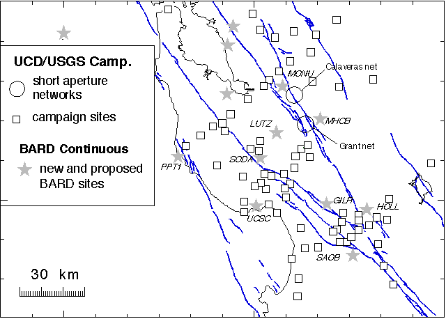
Figure 1. GPS stations used for this study.
Grant 1434-HQ-97-GR-03149
Roland Bürgmann
University of California, Berkeley
Department of Geology and Geophysics
385 McCone Hall
Berkeley, CA 94720-4760
(510) 643-9545, fax (510) 643-9980; burgmann@seismo.berkeley.edu
Program Element II. Evaluating Earthquake Potential
Keywords: Surface Deformation, Geodesy
The San Francisco Bay area (Bay Area) is home to about 5.9 million residents and is an important economic center. Large earthquakes in this area have the potential to cause significant loss of life and property damage. The southern Bay Area has experienced numerous historical earthquakes, including several moderate to large magnitude events. These include most recently the 1989 M7.1 Loma Prieta earthquake associated with the San Andreas fault, and the 1988 M5.1 Alum Rock, 1984 M6.2 Morgan Hill and 1979 M5.9 Coyote Lake earthquakes associated with the Calaveras fault.
The southern Bay Area is a structurally complex region of the North American-Pacific plate margin. The dominant tectonic feature of the region is the San Andreas fault system, which accomodates most of the slip associated with the transform plate margin. Geologic evidence suggests that the San Andreas fault (SAF) system is dominated by dextral strike-slip deformation along northwest trending faults with subsidiary thrust faults associated with the strain partitioning of a transpressional margin as well as local complexities. Geodetic measurements reveal a spatially complex deformation field with evidence for time-dependent strain that may affect the timing of future earthquakes in the Bay Area. Although the general nature of the plate boundary (right-lateral strike-slip with small amounts of contraction) is relatively unambiguous, several specific areas exhibit behavior that suggests structural complexities that may enhance earthquake hazards. It is imperative to evaluate the hazard from the primary northwest-trending strike-slip faults and from secondary active structures along the SAF system.
Since the 1989 Loma Prieta earthquake, we have performed repeated Global Positioning System (GPS) surveys and found significant differences between the active displacement field and that measured in the preceding two decades using Electronic Distance Measuring (EDM). The pattern of deformation suggests significant postseismic contraction across the youthful southern Santa Cruz Mountains northeast of the SAF. We monitored the details of anomalous post-seismic strain pattern by continuing to collect geodetic data from the southern Bay Area GPS network. Theoretical models based on these geodetic of fault interaction suggest that postseismic processes play an important role in the development of temporally and spatially clustered earthquakes. This project provides the best record to date of anomalous postseismic motions and their effects on neighboring seismogenic faults. Additionally, continuing geophysical studies allow us to estimate the current strain rates throughout the SAF system and evaluate areas that may present a seismic hazard.
The primary objective of this study was to monitor the spatially and temporally complex active deformation field in the southern Bay Area. Information from this study allows for the evaluation of the fault slip rates, which can be used to evaluate earthquake hazards in the region. We continued GPS observations of the southern Bay Area geodetic network in a mixed-mode approach of continuous GPS sites and yearly campaign surveys of the several networks.
The main objectives of this specific study included:
In particular, the proposed research addresses the following components of the NEHRP Program Element II(Evaluate Urban Hazard and Risk):
Additionally, as part of the proposed project plan, we have begun establishing semi-autonomous and continuous GPS stations to improve geodetic precision and time resolution. We have begun assembling a solar-powered system in which will serve as a roving autonomous GPS unit equipped with cellular phone communication for remote data transfer. The roving surveying mode promises highly precise time series that will constrain the local deformation at millimeter per year precision and will reliably monitor the time-dependent deformation. Additionally, the construction of two permanent continuous GPS stations in the southern Bay Area (SODA and LUTZ) continues to proceed toward an anticipated completion in 1999. These stations are planned additions to the Bay Area Regional Deformation (BARD) network. This enhancement of southern Bay Area geodetic monitoring promises to provide more thorough data to further our understanding of the earthquake cycle and the deep structure of the SAF system.
Data collection methods included the use of BARD network continuous GPS stations and periodic campaign-style GPS network observations. Figure 1 shows the complete GPS network that was monitored during this project. The Black Mountain, Loma Prieta, and Monterey profiles are part of a larger network established by the U.S. Geological Survey (USGS) that consists of six GPS profiles across the SAF system and the 5-station Loma Prieta Monitor network. To improve the spatial resolution of the displacement field following the Loma Prieta event, we reobserved a 22-station GPS network (Santa Cruz Mountains network) near the epicenter in 1994-1997 that was also surveyed in March and April of 1990.
Figure 1. GPS stations used for this study.
Most previously collected data from the southern Bay Area have been processed using the Bernese GPS processing software developed at the University of Bern. The continuous BARD data is currently processed with the GIPSY/OASIS 3 GPS processing software. Both software packages are used at the BARD collaborating institutions. All continuous data collected through the BARD network is processed with campaign data collected for this project during the same time period. The latest GPS data was processed at UC Davis in the weeks following the data collection. Careful comparisons were made to ensure successful integration of all data files in our velocity solutions. All BARD data and additional IGS sites in California for these days were included in the processing. Additionally, all the data used for this study (continuous and campaign data) are permanently archived at the BARD archive at UC-Berkeley and at UNAVCO.
After processing, GPS coordinate solutions then inverted for station displacement vectors using a least-squares linear inversion technique. Station velocities are relative to station BRIB and are shown in Figure 2.
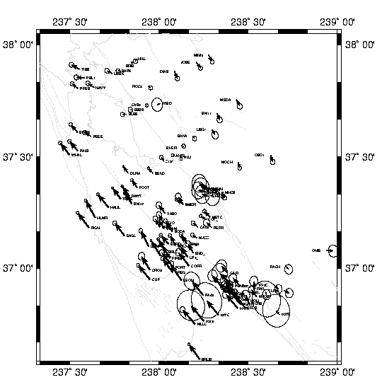
Figure 2. Station displacement field relative to the station BRIB (Briones) located east of the Hayward fault. Ellipses indicate the 95% confidence range of the velocities. The post-seismic relaxation signal from the 1989 Loma Prieta Earthquake has been removed from the velocity field.
We modeled the measured displacement field with rectangular displacement discontinuities for uniform slip in a homogeneous elastic half-space, or in an elastic layer above a viscous substrate. For the elastic models we calculated the elastic fields (displacements, stresses, strains, and tilts) caused by any amount of strike-slip, dip-slip, and opening displacement discontinuity on any number of arbitrarily striking and dipping rectangular fault elements.
The residual postseismic velocity field shown in Figure 3 represent the postseismic component of the measured signal that exceeds the secular deformation field. The observed horizontal displacement rates within a radius of ~20 km from the epicenter of the Loma Prieta earthquake differed significantly from those measured in the two decades preceding the earthquake. The anomalous displacements consist of up to 8 mm/yr of accelerated right-lateral shear parallel to and centered on the SAF. Horizontal site velocities in excess of the secular rates and the leveling data can be best explained by a dislocation model that includes a combination of aseismic reverse slip on a fault in the Foothills thrust belt northeast of the SAF and strike-slip on the SAF at relatively shallow depths. Additionally, we observed a zone of southwest-northeast contraction centered northeast of the Loma Prieta at rates exceeding 10 mm/yr (Figure 3). This zone extends as far east as HAMI across the Calaveras fault . This agrees at the first order with vertical displacements from a leveling survey along a ~60 km line across Loma Prieta showing ~15 mm/yr of uplift northeast of the SAF between 1990 and 1992.
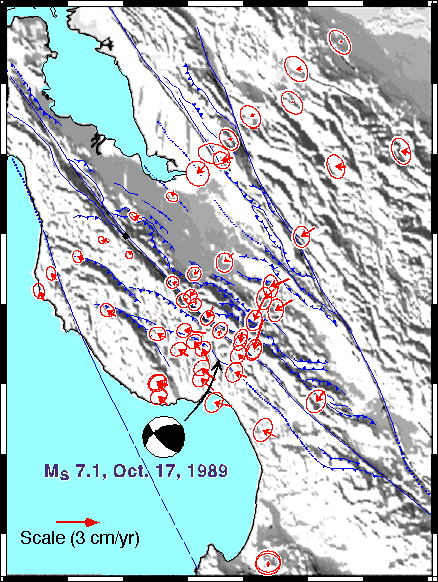
Figure 3. Station residual velocity map showing the post-seismic contraction southeast of the Loma Prieta rupture zone. Northeast-southwest contraction rates exceeded 10 mm/yr.
Our results indicate that anomalous contraction and uplift occur along the southwest-dipping Foothills thrust belt that uplifted the southern Santa Cruz Mountains including Loma Prieta in the late Cenozoic. The measured uplift and contraction rates are about an order of magnitude higher than geologic estimates. We found that average slip rates of 2-3 mm/yr are required on the underlying thrust system to achieve the ~1 mm/yr uplift rates suggested by their analysis of geologic, geomorphic and geodetic data. The accumulated geological and geophysical evidence suggest that the Monte Vista-Berrocal-Shannon thrust fault zones may form a considerable seismic hazard that is enhanced in the aftermath of the Loma Prieta earthquake.
In addition to a study of the post-seismic relaxation following the 1989 Loma Prieta earthquake, geodetic data is being used to model interseismic slip on the Calaveras fault. The Calaveras fault exhibits persistent aseismic zones that may represent locked patches which slip during moderate earthquakes. We model the fault slip along the Calaveras fault in an attempt to see if we can identify areas of decreased slip that may correspond to the aseismic areas of the fault.
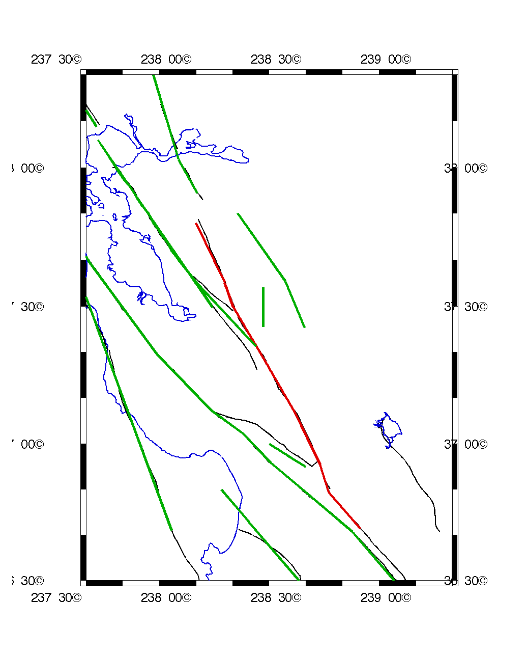
Figure 4. Fault geometry model used for inversion of surface displacement field for fault slip on the Calaveras fault (shown in red). Neighboring faults in the San Andreas fault system included in the model are shown in green.
We model slip on the fault as a screw dislocation in an elastic, isotropic, homogeneous half-space. We apply constraints to the direction (right-lateral) of slip, and the magnitude of slip on neighboring faults. We also apply a smoothing constraint to the model. We use two different fault models to invert the surface displacment field for slip on the fault:
The results so far are encouraging, and a complete statistical analyses of the result is currently ongoing. Figures 5-6 show the results for some of the fault slip inversions.
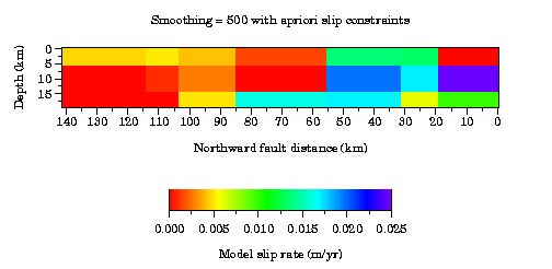
Figure 5.Modeled slip rate on the simple segmented Calaveras fault with apriori slip constraints on neighboring faults. Smoothing factor used is 500. Patches shown in purple have slip rates which exceed 25 mm/yr and are considered questionable.
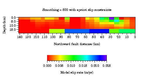
Figure 6.Modeled slip rate on the discretized segmented Calaveras fault with apriori slip constraints on neighboring faults. Smoothing factor used is 500. Patches shown in purple have slip rates which exceed 25 mm/yr and are considered questionable.
In addition to the modeling of slip on the Calaveras fault, we are developing a 3-D P-wave velocity model and relocating earthquakes in the Hayward-Calaveras fault stepover region. The results of this model will help to identify the method of slip transfer from the Calaveras fault to the Hayward fault, and possibly identify new seismic hazards.
We found anomalous horizontal displacement rates within a radius of ~20 km from the epicenter of the Loma Prieta earthquake of up to 8 mm/yr of accelerated right-lateral shear parallel to and centered on the SAF. The accelerated velocities are best explained model that includes a combination of aseismic reverse slip on a fault in the Foothills thrust belt northeast of the San Andreas fault and strike-slip on the San Andreas fault at relatively shallow depths. Additionally, we observed a zone of southwest-northeast contraction centered northeast of the Loma Prieta at rates exceeding 10 mm/yr. This zone extends eastward across the Calaveras fault .
The geodetic data obtained in the Sourthern San Francisco Bay region is also used to model the interseismic slip rate along the Calaveras fault in an attempt to identify locked areas of the fault. This modeling will assist in quantifying the slip deficit and locked areas which can then be used to estimated seismic moment release during earthquakes. The development of a 3-D P-wave velocity model for the Hayward-Calaveras fault stepover also will help to identify possible seismic hazards in the Southern San Francisco Bay region.
Bürgmann, R., Arrowsmith, R., and Dumitru, T., 1994a, Slip Rates and Earthquake Hazard Along the Foothills Thrust Belt in the Southern San Francisco Bay Area: USGS O. File Rep., p. 31-33.
Bürgmann, R., Arrowsmith, R., Dumitru, T., and McLaughlin, R., 1994b, Rise and fall of the southern Santa Cruz Mountains, California, deduced from fission track dating, geomorphic analysis, and geodetic data: J. Geophys. Res., v. 99, p. 20,181-20,202.
Bürgmann, R., Segall, P., Lisowski, M., and Svarc, J. P., 1992, Rapid aseismic slip on the Berrocal fault zone following the Loma Prieta earthquake: EOS Transactions, American Geophysical Union, v. 73, p. 119.
Bürgmann, R., 1995, Constraints on the subsurface geometry of the San Andreas fault system from geodetic data: EOS Transactions, American Geophysical Union, v. 76, p. F143.
Bürgmann, R., and S. Gross, 1996, Stress state and rate from Loma Prieta aftershocks: EOS Transactions, American Geophysical Union, v. 77 (46), p. 500-501.
Bürgmann, R., Segall, P., Lisowski, M., and Svarc, J. P., 1997a, Post-seismic strain following the 1989 Loma Prieta earthquake from repeated GPS measurements: USGS Prof. Pap., 1550, in press.
Bürgmann, R., Segall, P., Lisowski, M., and Svarc, J.L., 1997b, Postseismic Strain Following the 1989 Loma Prieta Earthquake From GPS and Leveling Measurements, Jour. of Geophys.Research, vol. 102, no. B3, p. 4933-4955.
Manaker, D. and Bürgmann, R., Displacement and strain across the Calaveras fautl from GPS and Trilateration data, eastern San Francisco Bay area, California: EOS Transactions, American Geophysical Union, v. 77, p. F147.
Manaker, D., Earthquake hazards associated with the Mission fault stepover between the Calaveras and Hayward faults, San Francisco Bay area, California: EOS Transactions, American Geophysical Union, v. 78, p. F159.
Additional data used in this study included RINEX format files obtained from the U.S. Geological Survey and the Bay Area Regional Deformation Network (BARD). These files include campaign-style surveying (USGS) and continuous GPS stations (BARD). For more information regarding data availability, contact:
Dr. Roland Bürgmann
Department of Geology and Geophysics
University of California, Berkeley
385 McCone Hall
Berkeley, CA 994720-4767
tel(w) (510) 643-9545
fax(w) (510) 643-9980
e-mail:burgmann@seismo.berkeley.edu
URL:http://www.seismo.berkeley.edu/~burgmann