
San Gabriel fault System (below)
The San Gabriel fault is an abandoned trace of the San Andreas fault system and once served as the primary plate boundary fault in Southern California. About 4 Ma, the active San Andreas system moved eastward to the northeast side of the San Gabriel mountains. Since that time, uplift and erosion have peeled away the overburden and exposures at the surface today were 2 - 5 km below the surface while the fault was active. These exposures allow us to look first-hand at the structure of a major plate-boundary fault in what was once the active seismogenic zone of the fault.
The best summary of the geologic history of the region, including the timing and total offset of the San Gabriel fault, is by Powell (1993). His best estimate is that the San Gabriel fault accommodated about 40 km of right-lateral motion between 13 - 4 Ma, though estimates range significantly.
Sample Locality (below)
< Directions >
The sample site itself is, in my opinion, one of the most dramatic exposures of a major fault anywhere on earth. It received quite a bit of attention in the geologic literature (Frontispiece, Oakeshott, 1958; Site 8, Anderson, 1983; Earthquake Fault site, Evans and Chester, 1995) and can be found on maps of the Angeles National Forest with the label "Earthquake Fault picnic area." the exposure is at the base of a dry waterfall (though it can form a majestic cascade after heavy rains). The site is easily accessible by driving north on Little Tujunga Road from Interstate 210 and stopping at a picnic table located in a hairpin turn.
The fault itself consists of an extremely narrow gouge zone. At Transect E, there is an ultracataclasite layer from 5 - 10 cm wide surrounded by intact rock on either side. Thin sections reveal moderate grain crushing, but all deformation is brittle and samples look intact in hand specimen. Transect B is slightly more complex. The ultracataclasite layer itself is extraordinarily narrow -- ranging from less than 1 cm to about 3 cm. On the southwest side of the fault, there is a zone of foliated cataclasite where there is clear evidence for brittle shearing in thin sections and hand samples are visibly distinct from the adjacent granodiorite. The zone is about 30 cm wide, but its width varies locally along the outcrop. The boundary between the foliated cataclasite and more intact granodiorite is abrupt, but curves around a fair amount does not appear to be faulted. Samples within the foliated zone have similar fission track ages (identical within statistical error), but a trend in the four data points closest to the fault suggests that there may be evidence for a small amount (<150 m) of differential uplift that could be accommodated within this foliated layer. The northeast side of the fault at this locality shows a similar trend in fission track age but because the gneiss is very old and deformed, it's difficult to determine anything about brittle shearing from the thin sections.
See the Thin Sections
Cumulative Offset
While the 40 km total offset of the San Gabriel fault system is well constrained, it is not clear how slip is partitioned between the various segments of the fault on the scale of 10's of meters, such as the area around the sample locality shown in the map above. What can be said is that the trace identified here as the San Gabriel fault is a prominent lithologic boundary between a granodiorite to the southwest and a Precambrian gneiss to the northeast. Tracing these units east along strike, this segment must have at least several kilometers of slip, making it a significant player in the plate boundary. As such, it's amazing to think that as much as 40 km of cumulative displacement occurred within a gouge zone just 1 cm wide!
Nearby Fault Segments
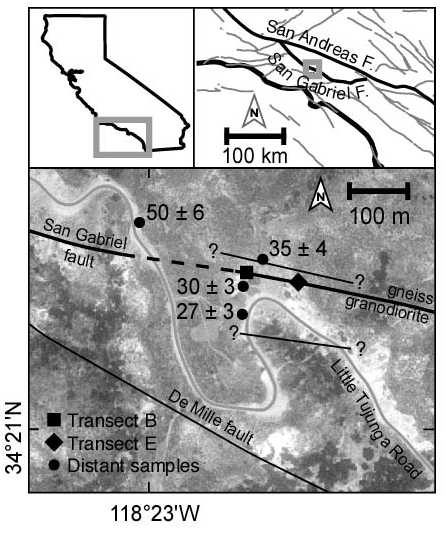
As the air-photo image above shows, there are a few other faults 10 - 100 m from the main trace of unknown age and extent. The small fault about 10 m north of the main San Gabriel fault is part of a "flower structure" in the fault and it dips towards the San Gabriel fault at an angle of about 70 degrees and projects along dip into the San Gabriel fault a few meters below the surface. This fault probably forms a significant structural boundary and likely intersects the San Gabriel fault east of Transect E, though cover makes it difficult to trace. This would put the north side of Transect E in crotch of a three-way intersection between faults with significantly different dips. Such an area could conceivably rotate and/or pop-up, which could explain the anomalously old ages (70 Ma) observed on the north side of Transect E. The same small fault runs just south of sample 8F-1 (age 35+-4 on the map above) and also should extend north of sample 8F-2 (age 50+-6) such that sample 8F-2 is in the same block as Transect B. The De Mille fault is younger than the San Gabriel fault and likely has a few kilometers of total slip at most. It intersects the San Gabriel fault just west of the map below and again a few further to the east.
Read Field Notes Online
Evans and Chester (1995) show that this sample locality has minimal evidence for the presence of abundant fluids or high fluid pressures. Other localities along the San Gabriel fault and Punchbowl fault have significant evidence for high fluid pressures, but this site is different. Those other sites have much wider zones of cataclasite and ultracataclasite on the order of 0.5 - 2 m wide while the ultracataclasite layer at this site is on the order of a few centimeters.
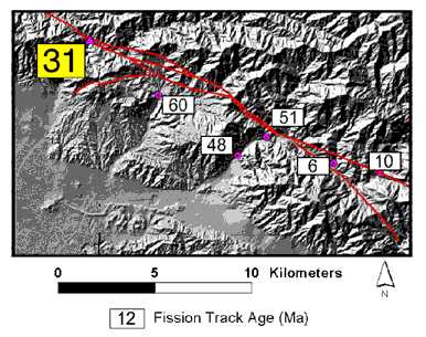
Nearby Fission-Track Ages (above)
The age of our sample locality (south side of fault) compared with nearby ages from Blythe et al. (2000).