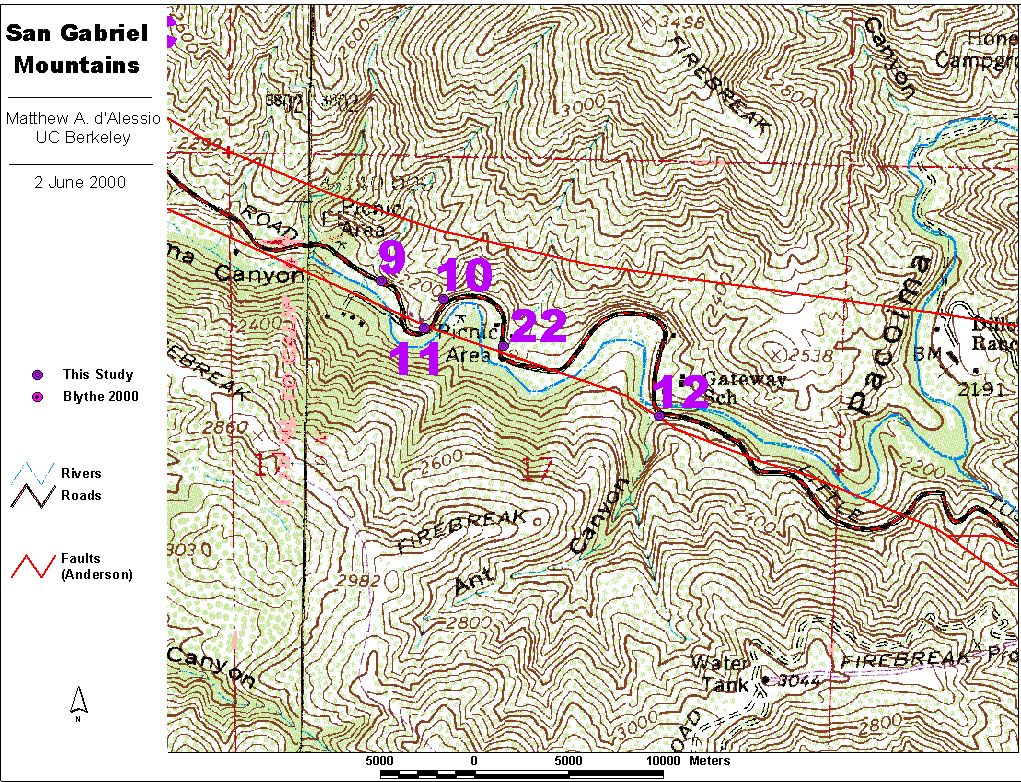
San Gabriel Fault Zone Field Notes
West Side
Matthew A. d'Alessio
UC Berkeley Active Tectonics
dalessio@seismo.berkeley.edu
Not for publication
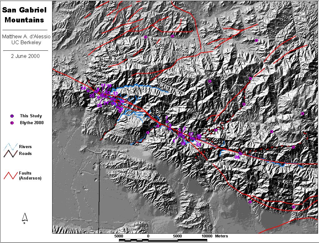
Vicinity Map with USGS 7.5' Quad Outlines
INTRODUCTION
The following is a summary of the location and structure of the San Gabriel fault obtained from a brief reconnaissance trip. It might be useful for other geologists interested in taking a field trip to one of the world's finest examples of an exhumed plate-boundary scale strike-slip fault zone. Please let me know if you find this information useful or have any further questions.
OBJECTIVE
Determine sites logistically and thermally suitable for thermochronological investigation of shear heating on an exhumed fault.
REGION OF INTEREST
San Gabriel Fault Zone, San Gabriel Mountains, California
West end from Santa Clara Divide to Red Box Gap
DATES
22 May 2000 - 29 May 2000
Note:
All coordinate locations are given in UTM Zone 11 North, NAD 1927. These are not the default projection or datum for most GPS receivers but are the standard for older USGS Topo maps.
REFERENCES
Anderson, J. L., Osborne, R. H. & Palmer, D. F. 1983. Cataclastic rocks of the San Gabriel Fault; an expression of deformation at deeper crustal levels in the San Andreas fault zone. Tectonophysics 98(3-4), 209-251.

Blythe, A. E., Burbank, D. W., Farley, K. A. & Fielding, E. J. 2000. Structural and topograhic evolution of the central Transverse Ranges, California, from apatite fission-track, (U-Th)/He and digital elevation model analysis. Basin Research in review.

Chester, F. M., Evans, J. P. & Biegel, R. L. 1993. Internal structure and weakening mechanisms of the San Andreas Fault. Journal of Geophysical Research, B, Solid Earth and Planets 98(1), 771-786.

Oakeshott, G. B. 1958. Geology and mineral deposits of San Fernando quadrangle; Los Angeles County, California. California Division of Mines & Geology Bulletin 172, 147 p.
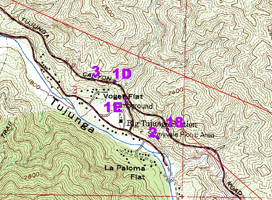
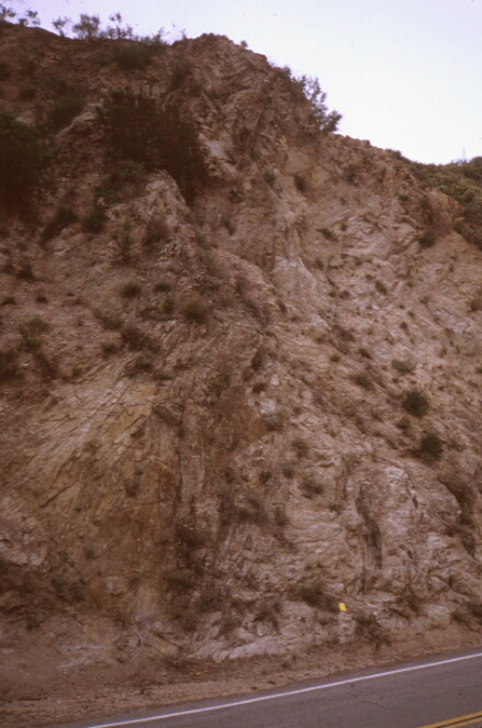
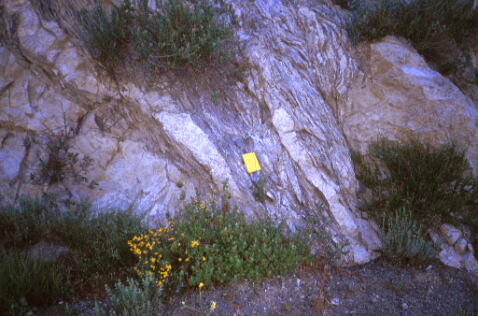
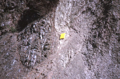
1D
Anderson 12 |
1:200,000 Vicinity Map
|
1:10,000 Local Topo Map
|
Easting 387164
Northing 3794751
|
On Big Tujunga Canyon Road just across the street from Vogel Flat Road.
Station 1D (in photo below) is immediately adjacent to a yellow diamond-shaped sign on the north side of the road and across the street from a Slide Area sign which is on the south side.
|
|
|
Photo
|
|
Description
|
14 m wide zone of foliated rock with occasional gouge.
|
|
Looking
|
N45W
|
|
Scale
|
yellow notebook (19 x 12.5 cm)
|
|
Rock Type(s)
|
Granitic with evidence for some chloritic alteration
|
|
Orientations
|
Foliation orientation is extremely variable between N85W and N10W with dips between 75E and Vertical.
|
|
Numerous small faults in the granitic rocks nearby. Many show slickenlines (12 degrees down to the east). The projection of the zone shown above is onto Vogel Flat Road (see site 2).
|
|
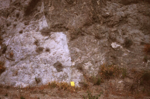
1E
|
1:200,000 Vicinity Map
|
1:10,000 Local Topo Map
|
Easting 387266
Northing 3794570
|
On Vogel Flat Road about 100 m down the road from the intersection with Big Tujunga Canyon Road.
|
|
|
Site
|
|
Description
|
A distinct zone of altered rock that seems to erode very easily. Seems to fit the projection of 1D, but not necessarily. Also, there are two outcrops that may be parallel rather than continuous that are observed in different parts of the roadcut.
|
|
|
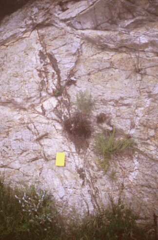
3
|
1:200,000 Vicinity Map
|
1:10,000 Local Topo Map
|
Easting 386973
Northing 3794772
|
On Big Tujunga Canyon Road a hundred or so meters west of Vogel Flat Road. GPS point is on the south side of the road, outcrops in roadcut on the north side.
|
|
|
Photo
|
|
Description
|
1 cm wide Gouge layer offset a darker, finer-grained granitic rock from a lighter coarser grained granitic rock. Some evidence of hydrothermal alteration.
|
|
Looking
|
North
|
|
Scale
|
yellow notebook (19 x 12.5 cm)
|
|
Rock Type(s)
|
Granodiorite?
|
|
Orientations
|
Fault N6E, 70E
|
|
|
Photo
|
|
Description
|
Xenoliths stretched and aligned with mafic foliations. Faults cut across the frame nearly horizontally.
|
|
Looking
|
North
|
|
Scale
|
yellow notebook (19 x 12.5 cm)
|
|
Rock Type(s)
|
Granitic
|
|
Orientations
|
Fault? N40W, 75E
|
|
Between points 1 and three, there are several large discontinuities that look like significant faults in the granitic rock. The material on both sides of the faults is homogeneous, constraining the offset.
|
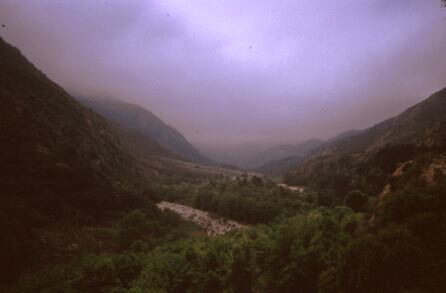
5
Anderson 11
|
1:200,000 Vicinity Map
|
1:10,000 Local Topo Map
|
Easting 385297
Northing 3795694
|
On Big Tujunga Canyon Road. GPS point on south side of road and outcrop is the roadcut on the north side.
|
|
|
Photo
|
|
Description
|
Big Tujunga Canyon, San Gabriel Fault should run down this.
Taken from milepost 2.92, about 100m east of this GPS point.
|
|
Looking
|
S45E
|
|
4 - 7 cm of gouge separate finer grained leucogranite? from a more foliated granite. The fault is at N20E, 45E but curves significantly locally.
|
|
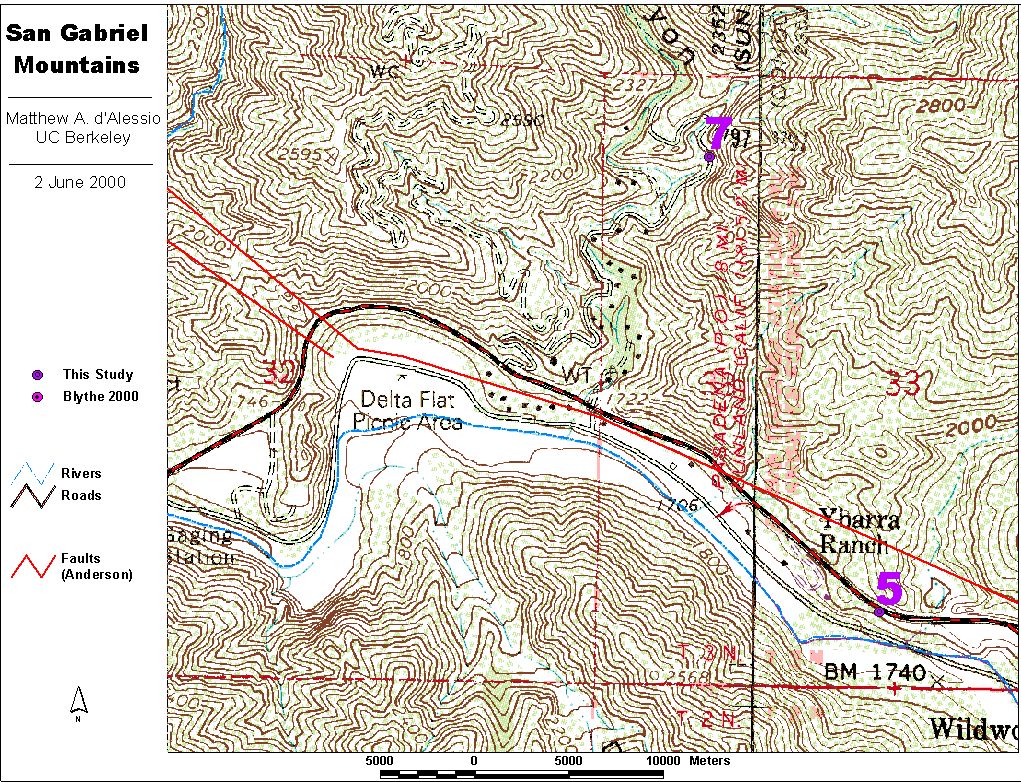
7
|
1:200,000 Vicinity Map
|
1:10,000 Local Topo Map
|
Easting 384846
Northing 3796897
|
On trail on the east side of the creek that runs of Trail Canyon. (FS Trail 13W03)
Access by taking the dirt road turnoff marked Gold Creek Road /Trail Canyon Road going north off of Big Tujunga Canyon road. This point is on the trail at the very end of the road near several houses.
|
|
|
Site
|
|
Description
|
Nice granite. This hiking trail is very pleasant and takes you through a leucogranite? that shows very little signs of faulting at all. A good place to obtain a "background" sample for this part of the fault zone.
|
|
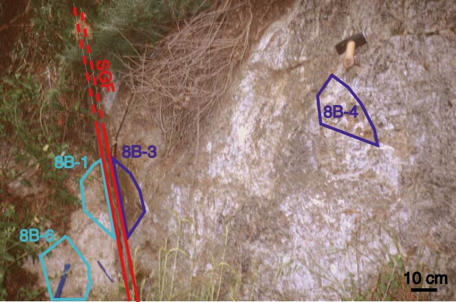
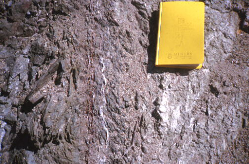
8B
Earthquake Fault Site
Anderson 8
|
1:200,000 Vicinity Map
|
1:10,000 Local Topo Map
|
|
|
A US Forest Service interpretive site with a large sign identifying this as the San Gabriel Fault, a picnic table, a BBQ, and a trash can. You can't miss it.
On Little Tujunga Road at a sharp bend in the road. About half way between Dillon Divide and Bear Divide (closer to Bear Divide) close to where the road leaves the valley floor on the west end of that stretch.
|
|
|
Photo
|
|
Description
|
Fault with .5 - 4 cm gouge.
|
|
Looking
|
N78W
|
|
Scale
|
yellow notebook (19 x 12.5 cm)
|
|
Rock Type(s)
|
Granodiorite on West (left side) (Josephine Granodiorite, Anderson 1983)
Granitic Gneiss on East (right side) (Mendenhall Gneiss, Anderson 1983)
|
|
Orientations
|
Fault N78W, 77NE
|
|
|
Photo
|
|
Description
|
Location of Sample 8B-1
|
|
Photo
Annotated Photo
|
|
Description
|
Location of Samples around fault 8B
8B-1 at the top of the blue eraser, granodiorite, 1 - 15 cm from fault
8B-2 not shown, granodiorite, 67 meters from fault at GPS 372894/3801999
8B-3 at the bottom of the red pencil, gneiss, 1 - 3 cm from fault
8B-4 at base of sledge hammer handle, gneiss, 45 - 55 cm from fault
8B-5 not shown, granodiorite, 8 - 10 m from fault
8B-6 at base of blue chisel, granodiorite, 30 - 45 cm from fault
|
|
8C
Earthquake Fault Site
|
1:200,000 Vicinity Map
|
1:10,000 Local Topo Map
|
Easting 372967
Northing 3802062
|
A US Forest Service interpretive site with a large sign identifying this as the San Gabriel Fault, a picnic table, a BBQ, and a trash can. You can't miss it.
On Little Tujunga Road at a sharp bend in the road. About half way between Dillon Divide and Bear Divide (closer to Bear Divide) close to where the road leaves the valley floor on the west end of that stretch.
Site 8C can be reached by heading east from the dry waterfall along a path formed at the break in slope.
|
|
|
Photo
|
|
Description
|
The view of my truck nearly directly below me. Why do I have to be afraid of heights?
|
|
|
Photo
|
|
Description
|
The wiew of fault 8B from 8C. Fault seems to follow hillside but the southwest side is covered by lots of colluvium and could conceivably be a very large fallen block, but I don't think so. There is a spot where the cleavage forms in the foliated rock is nearly parallel on both the hillside and what appears to be a fallen block. Additionally, the fault at 8E projects properly reasonably well onto the same fault at 8B, a big coincidence if this block slid here. The dip of the cleavage (which appears to occur along a major fault ~.5 m wide) is opposite of the fault at 8B and parallel to the hillslope.
|
|
Looking
|
N78W
|
|
Scale
|
None |
|
Rock Type(s)
|
Granodiorite on West (left side)
Granitic Gneiss on East (right side)
|
|
Orientations
|
Fault 8B N78W, 77NE
|
|
|
Photo
|
|
Description
|
Hillslope Parallel Cleavage that could form a major fault boundary.
|
|
Looking
|
Northwest
|
|
Scale
|
yellow notebook (19 cm x 12.5 cm) |
|
Rock Type(s)
|
Gneiss with well developed cleavage foliations and some hard white secondary mineral filling (qtz).
|
|
Orientations
|
Cleavage foliation: N42W, 64W
|
|
8D
Earthquake Fault Site
|
1:200,000 Vicinity Map
|
1:10,000 Local Topo Map
|
|
|
A US Forest Service interpretive site with a large sign identifying this as the San Gabriel Fault, a picnic table, a BBQ, and a trash can. You can't miss it.
On Little Tujunga Road at a sharp bend in the road. About half way between Dillon Divide and Bear Divide (closer to Bear Divide) close to where the road leaves the valley floor on the west end of that stretch.
Site 8D is the base of the dry waterfall.
|
|
|
Photo
|
|
Description
|
The view of the dry waterfall and fault at 8D. The area is very moist and rock is entirely covered by lichen on the west side.
|
|
Looking
|
N20W
|
|
Scale
|
yellow notebook (19 cm x 12.5 cm) |
|
Rock Type(s)
|
Granitic Gneiss on West (left side)
Finer grained pelitic gneiss on East (right side)
|
|
Orientations
|
Fault N60E, 67W. Looks like this curves to connect to the hillslope parallel fault? of 8C.
|
|
8E
Earthquake Fault Site
|
1:200,000 Vicinity Map
|
1:10,000 Local Topo Map
|
|
|
A US Forest Service interpretive site with a large sign identifying this as the San Gabriel Fault, a picnic table, a BBQ, and a trash can. You can't miss it.
On Little Tujunga Road at a sharp bend in the road. About half way between Dillon Divide and Bear Divide (closer to Bear Divide) close to where the road leaves the valley floor on the west end of that stretch.
Site 8E is southeast along the projection of fault 8B. It is a few meter wide outcrop exposed in a small steep gulley.
|
|
|
Photo
|
|
Description
|
Sample 8E-1 and the 4 - 9 cm wide gouge zone. This fault is the same fault as 8B.
|
|
Looking
|
S70E
|
|
Scale
|
Chisel
|
|
Rock Type(s)
|
Josephine Granodiorite on West (right side)
Granitic Gneiss on East (left side)
|
|
Orientations
|
Fault N70W, 85E
|
|
|
9
|
1:200,000 Vicinity Map
|
1:10,000 Local Topo Map
|
Easting 373731
Northing 3801482
|
Exposure on the North Side of Little Tujunga Road. The GPS point is taken on the south side by the river.
|
|
|
Site
|
|
Description
|
A wide zone of distributed faulting in granitic rock. Fault orientations range from nearly horizontal to nearly vertical. As far as I can tell, the entire 100m long outcrop has lots of faults and there is no significant slip localization.
|
|
|
|
10
|
1:200,000 Vicinity Map
|
1:10,000 Local Topo Map
|
Easting 373894
Northing 3801434
|
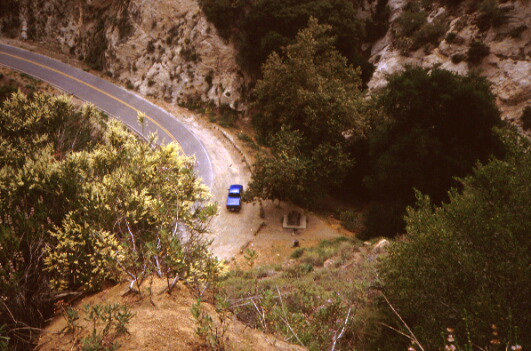
On the north side of Little Tujunga Road just around the corner from 9.
|
|
|
Site
|
|
Description
|
Similar to site 9. Many faults in granitic rock with lots of dikes to help indicate shear sense. Back of "Turnout" sign of Site 11 can be seen in the background.
|
|
Looking
|
S45W
|
|
Scale
|
Truck parked at point 10
|
|
Rock Type(s)
|
Leucogranite, granodiorites cut by aplite dikes.
|
|
|
|
|
11
|
1:200,000 Vicinity Map
|
1:10,000 Local Topo Map
|
|
On the same stretch of road as site 10 but about 50 m nortwest of 10, on the north side of the road near the "Turnout 1/4 mile" sign.
|
|
|
Photo
|
|
Description
|
2 cm wide, foliated black and brown cataclasite.
|
|
Looking
|
N65W
|
|
Scale
|
yellow notebook (19 x 12.5 cm)
|
|
Rock Type(s)
|
Leucogranite northeast (right) side
Red sedimentary breccia with clasts up to 3 cm. Highly weathered. Southwest (left) side.
|
|
Orientations
|
Fault at base: N67W, 68W. Appears to have a major kink about halfway up the frame.
|
|
|
|
12
|
1:200,000 Vicinity Map
|
1:10,000 Local Topo Map
|
Easting 374489
Northing 3801144
|
On Little Tujunga road just south of bridge near mile marker 11.3
|
|
|
Photo
|
|
Description
|
Minor fault with interesting internal structure.
|
|
Looking
|
West
|
|
Scale
|
yellow notebook (19 x 12.5 cm)
|
|
Rock Type(s)
|
Very light leucogranitic on north (right) side
Dark, deeply weathered granitic(?) on south (left) side
Some evidence of epidote chlorite in nearby rock.
|
|
Orientations
|
North (right) bounding fault: N58E, 72E
South (left) bounding fault: N75E, 69E
|
|
|
|
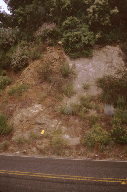
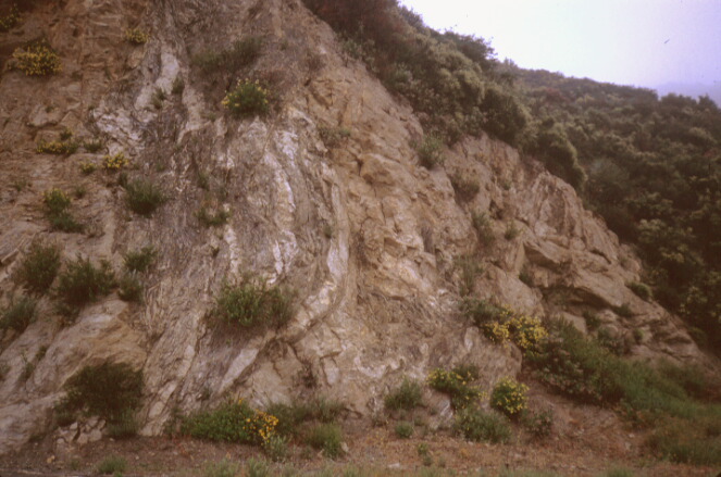
13
|
1:200,000 Vicinity Map
|
1:10,000 Local Topo Map
|
Easting 375682
Northing 3800763
|
At the big turn in Little Tujunga Road.
GPS point taken on west side of road in the drainage ditch across the street from the culvert labeled LA County 1936 DC-2.
|
|
Photo
Photo
Photo
|
|
Description
|
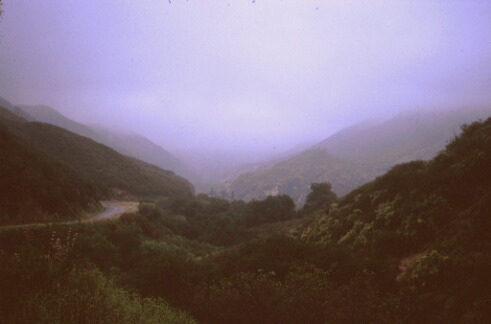
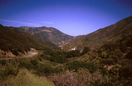
Major grey foliation cleavage in the granodiorite. The zone is about 4 m wide and consists of parallel cleavage planes about 2-4 cm apart giving the appearance of a nearly vertical bedding in a discrete zone of the granitic rock. This zone can be traced up the hill into the valley behind. The main strand of the fault is clearly nearby because that valley is the major drainage and on the other side of the valley is the darker gneiss seen at site 8.
|
|
Looking
|
Southwest
|
|
Scale
|
|
|
Orientations
|
N90E, 60S, highly variable locally.
|
|
Photo
Photo
|
|
Description
|
Two views (one in the mist and one the next day in the bright sun) looking back towards site 8 (the red house in the center furthest to the right is above and just to the left of the fault at site 8). The Fault goes down this valley.
|
|
Looking
|
N62W
|
|
|
|
14
|
1:200,000 Vicinity Map
|
1:10,000 Local Topo Map
|
Easting 375948
Northing 3800653
|
On Little Tujunga road a few hundred meters south of Dillon Divide.
|
|
|
Site
|
|
Description
|
Several large faults, but one major fault clearly separates granitic rocks from gneissic rocks. This fault probably connects with 13.
|
|
Looking
|
North
|
|
Scale
|
yellow notebook (19 x 12.5 cm)
|
|
Rock Type(s)
|
Granodiorite, north side (right)
Gneiss, south side (left)
|
|
Orientations
|
Main fault is N90E, 65S
two close-by faults are N75W, 70S (south side) and N70E, 70NW (north side)
|
|
|
Photo
|
|
Description
|
About 50m north of the major fault, this minor fault in granitic rock has a 2 cm wide gouge zone with what appear to be pockets of injected cataclasite.
|
|
Looking
|
N70W
|
|
Scale
|
yellow notebook (19 cm x 12.5 cm)
|
|
Rock Type(s)
|
Granodiorite
|
|
Orientations
|
Fault N70W, 70E
|
|
|
Site |
|
Description
|
Another zone of cleavage foliations like at 13. This one at GPS 375968 / 3800711 and is about 5m wide. A very obvious fault a few meters from this zone is also present.
|
|
Rock Type(s)
|
Granitic
|
|
Orientations
|
Cleavage Foliation: N30E, Vertical - 80W
|
|
This entire curve of the road is marked by excellent exposures of smaller faults.
|
15
Anderson 9
|
1:200,000 Vicinity Map
|
1:10,000 Local Topo Map
|
Easting 376785
Northing 3799886
|
Roadcut On west side of Little Tujunga road near high tension power lines uphill from Barrell Springs
|
|
|
Site
|
|
Description
|
A wide, 15 m wide gouge zone
|
|
Rock Type(s)
|
Gneiss, north side (Diorite Gneiss, Anderson 1983)
Conglomerate, south side (Martinez Formation, Anderson 1983)
Conglomerate is covered by colluvium on the south side of the gouge zone but is present further south.
|
|
Orientations
|
Gouge zone appears to strike N45E, 45W. Orientation is a very rough estimate.
|
|
|
|
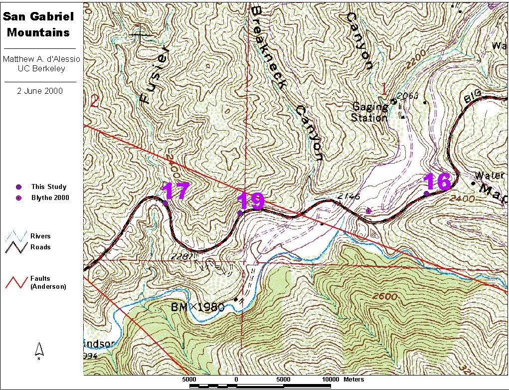
16
|
1:200,000 Vicinity Map
|
1:10,000 Local Topo Map
|
Easting 390314
Northing 3794116
|
Roadcut on the south side of Big Tujunga Canyon Road across the street from the fencing around the Big Tujunga Dam.
|
|
|
Site
|
|
Description
|
A well foliated zone in the granitic rock, like at site 13 but this one is about 50 meters wide.
|
|
Orientations
|
Cleavage Foliation: N45W, 85W but highly variable locally.
|
|
|
17
Anderson 14
|
1:200,000 Vicinity Map
|
1:10,000 Local Topo Map
|
Easting 388927
Northing 3794067
|
Roadcut on the north side of Big Tujunga Canyon Road east of Fusier Canyon. About 100m east of "Trailhead Parking 700 feet Ahead" sign.
|
|
|
Photo
|
|
Description
|
A fault with up to 15 cm of gouge. Gneissic Foliation (Cleavage foliations) in granitic rock seem to change orientation to become parallel with the main fault zone as they approach it.
|
|
Looking
|
S76E
|
|
Scale
|
yellow notebook (19 cm x 12.5 cm)
|
|
Rock Type(s)
|
Granitic, with some evidence of chloritic alteration. (Adamellite, Anderson 1983)
|
|
Orientations
|
Fault N76W, 85S - vertical.
Strongly developed cleavage is N45W, 75N far from the fault and N55W, 85S near the fault at the level of the road. It appears to curve closer to the main fault orientation higher up.
Another fault to the right is N55W, 75N
|
|
|
Photo
|
Description
|
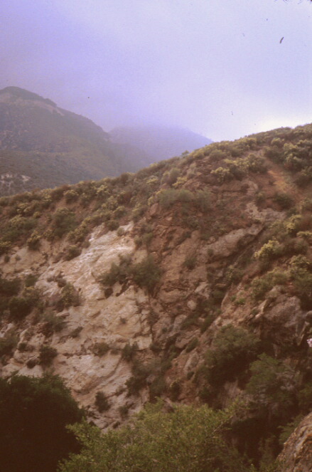
Pretty View of the clouds
|
|
Looking
|
West towards Mt. Lukens (?)
|
|
|
18
Anderson 13
|
1:200,000 Vicinity Map
|
1:10,000 Local Topo Map
|
Easting 387612
Northing 3794342
|
Roadcut North side of Big Tujunga Canyon Road, about .8 km southeast of Vogel Flat Road
|
|
|
Site
|
|
Description
|
2 Faults, with the east fault slightly obscured by landsliding
|
|
Rock Type(s)
|
Granitic (adamellite w/ biotite or amphibolite gneiss, Anderson 1983)
|
|
Orientations
|
Fault: N80W, 75E
Foliation locally variable, but average N55W, 89E.
|
|
This may not be the faults identified by Anderson as he observed gouge zones 5 - 10 cm thick and the thickest I saw was 5 cm.
|
|
19
|
1:200,000 Vicinity Map
|
1:10,000 Local Topo Map
|
Easting 389323
Northing 3794013
|
Roadcut on north side of Big Tujunga Canyon one turn west of the Big Tujunga Dam bridge, about halfway between Fusier Canyon and Breakneck Canyon.
|
|
|
Site
|
|
Description
|
Cleavage foliations like in 13, but only about 2m thick.
|
|
Rock Type(s)
|
Granitic
|
|
Orientations
|
Cleavage Foliations: N90E, 80N
|
|
|
|
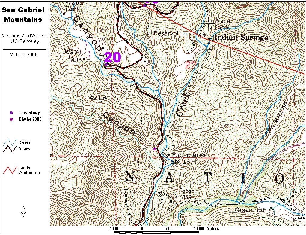
20
|
1:200,000 Vicinity Map
|
1:10,000 Local Topo Map
|
Easting 376446
Northing 3799366
|
Roadcut on the north side of Little Tujunga Road at the first big turn in the road. Just outside the Wildlife Waystation gate.
|
|
|
Site
|
|
Description
|
Migmatized Diorite Gneiss with Cleavage foliations like in 13. Layer is nearly 50m thick
|
|
Rock Type(s)
|
Granitic / Granitic Gneiss
|
|
Orientations
|
Cleavage Foliations: N10W - N30W, 85W - vertical
|
|
|
|
21
|
1:200,000 Vicinity Map
|
1:10,000 Local Topo Map
|
Easting 375446
Northing 3800788
|
Roadcut on north side of Little Tujunga Road near creek.
|
|
|
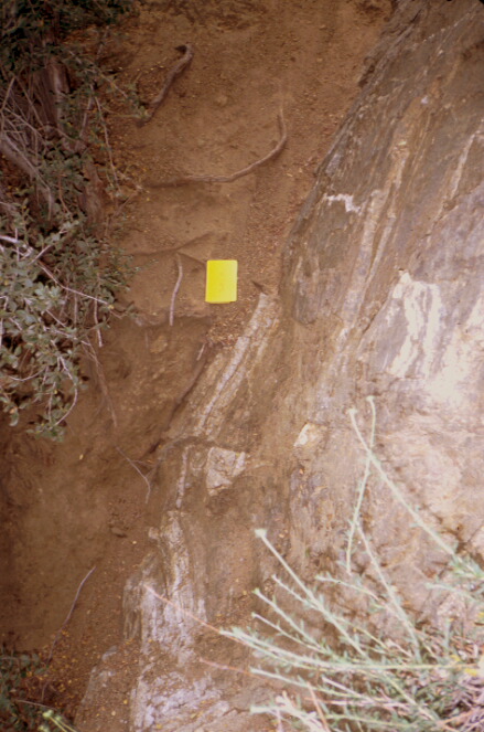
Site |
|
Description
|
A fault with about 1 cm gouge. It appears to juxtapose lighter granitic rock on the west with darker granitic rock on the east, though I didn't spend much time looking at it.
|
|
Orientations
|
Fault: N21W, 83W
|
|
|
|
22
|
1:200,000 Vicinity Map
|
1:10,000 Local Topo Map
|
Easting 374023
Northing 3801317
|
Roadcut on north side of road at turn in Little Tujunga Road.
|
|
|
Site
|
|
Description
|
Conglomerate of Site 10 with granitic rock nearby. Most of the rock is too weathered to determine the exact location of the contact/fault.
|
|
|
|
23
|
1:200,000 Vicinity Map
|
1:10,000 Local Topo Map
|
Easting 372745
Northing 3802094
|
The first outcrop after the rounding the corner out of site uphill past site 8 (Earthquake Fault Interpretive Site). Roadcut on east side of road and small canyon over the west side.
|
|
|
Photo
|
|
Description
|
The roadcut outcrop contains only lightly foliated granitic gneiss but the fault must be close by. The photo looks at the fault of 8B on the canyon across the street from this outcrop. The gneiss-granodiorite contact can clearly be seen near the oak tree in this frame. It may also be possible to see the contact between these two units way up on the mountain side.
|
|
Looking
|
N85W
|
|
Scale
|
Oak Tree
|
|
Rock Type(s)
|
Josephine Granodiorite, southwest (left) side (Anderson, 1983)
Mendenhall Gneiss, northeast (right) side (Anderson, 1983)
|
|
Orientations
|
Fault Trends ~N85W, given foreground and background outcrops in picture...
|
|
|
|
24
|
1:200,000 Vicinity Map
|
1:10,000 Local Topo Map
|
Easting 371460
Northing 3802127
|
At large turnout on north side of May Canyon Road a kilometer or so above the Bear Divide Ranger Station.
|
|
|
Site
|
|
Description
|
This appears to be the same contact as at site 23, but I am now several km away and it's difficult to determine if the rock units coincide. The fault does not appear to project linearly to this point from 23 unless the dip stays far from vertical -- the elevation at this point is much higher than at 8 and 23 so we could expect considerable curving uphill. Other options include this fault being offset right laterally across the canyon, a curve in the fault, or I'm looking at another fault entirely.
|
|
|
Photo
|
|
Description
|
Actually taken a ways down the hill from 24, this photo looks down Little Tujunga Canyon back at 13 at the curve in the road.
|
|
Looking
|
S65E
|
|
|
Photo
|
|
Description
|
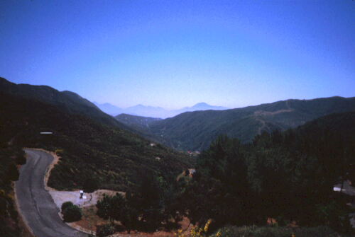
Taken from the Bear Divide Plantation of Penny Pines rest area, this photo looks the other direction towards Palmdale. Note the contrast!
|
|
Looking
|
Northwest
|
|
|
|
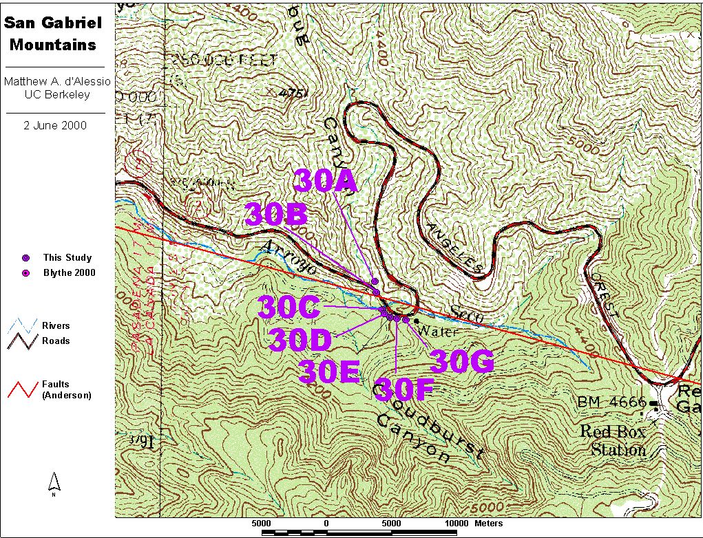
30A
|
1:200,000 Vicinity Map
|
1:10,000 Local Topo Map
|
|
|
Multiple Outcrops at a turn in Angeles Crest Highway before the first big turn when traveling east to Red Box Gap. The valley of Clear Creek narrows here.
30A is in a drainage ditch on the north side of the road.
|
|
|
Site
|
|
Description
|
2 nice exposures of two roughly parallel foliated fault zones with cataclasite layers 30 - 40 cm thick. Strike appears E-W, but didn't go down in ditch to observe directly. That strike would make them cross the canyon/intersect with the trend of the valley where, presumably, the 'main fault' exists.
|
|
|
|
30B
|
1:200,000 Vicinity Map
|
1:10,000 Local Topo Map
|
Easting 397249
Northing 3791532
|
Multiple Outcrops at a turn in Angeles Crest Highway before the first big turn when traveling east to Red Box Gap. The valley of Clear Creek narrows here.
30B is in a roadcut on the North side of the road at the northern part of the curve on the downhill limb.
|
|
|
Site
|
|
Description
|
20 cm wide foliated zone with cataclasite.
|
|
Rock Type(s)
|
Weathered granodiorite Northwest side
Very white granitic with almost pure quartz and feldspar on Southeast side
Some mafic minerals looks slightly hydrothermally altered.
|
|
Orientations
|
Fault: N70E, 85E, varies locally
|
|
|
|
30C
|
1:200,000 Vicinity Map
|
1:10,000 Local Topo Map
|
|
|
Multiple Outcrops at a turn in Angeles Crest Highway before the first big turn when traveling east to Red Box Gap. The valley of Clear Creek narrows here.
30C is just south of a Fire road gate in the heart of the turn.
A picture from ~30C looking West
|
|
|
Site
|
|
Description
|
"Crush Zone" where fractures are very closely spaced and oriented in all directions, some showing a gouge-like filling 3 - 5 mm thick. Slicks are observed on one of these fracture surfaces in at least one location.
|
|
|
|
30D
|
1:200,000 Vicinity Map
|
1:10,000 Local Topo Map
|
|
|
Multiple Outcrops at a turn in Angeles Crest Highway before the first big turn when traveling east to Red Box Gap. The valley of Clear Creek narrows here.
30D is adjacent to 30C in the heart of the turn. |
|
|
Site
|
|
Description
|
A wedge of highly altered green rock that is fault bounded on both sides. At the base of the exposure (along the road), the wedge is 5 m wide and the apex of the triangle is a few meters above.
|
|
Photo
Photo
|
|
Description
|
The boundary between C and D is a 20 - 50 cm wide fault with red-brown cataclasite with curving white veins a few mm thick and roughly parallel to the cataclasite boundaries.
|
|
Looking
|
S35E
|
|
Scale
|
yellow notebook (19 cm x 12.5 cm)
|
|
Rock Type(s)
|
Highly fractured Granitic rock with some evidence of hydrothermal alteration (light green color) West (right) side
White veins (center right)
Dark brown and foliated Red-Brown cataclasite (center left)
Highly altered green rock East, (Left)
Granitic with much less fracturing Far East (Far Left, only on zoomed-out picture)
|
|
Orientations
|
Fault at C-D boundary: N35W, Vertical
Fault within D: N25E, 75S
|
|
|
|
30E
|
1:200,000 Vicinity Map
|
1:10,000 Local Topo Map
|
|
|
Multiple Outcrops at a turn in Angeles Crest Highway before the first big turn when traveling east to Red Box Gap. The valley of Clear Creek narrows here.
30E is west of 30F and east of 30D in the heart of the turn.
|
|
|
Site
|
|
Description
|
Granitic rock with very few faults and fractures in it compared to surrounding rock units. Does have several faults that splay off of the central fault that cuts 30D.
There is a narrow section of well foliated granitic rock within this unit. Some of these cleavage along these foliations display dark red coloring like Iąve seen on surfaces that are clearly slickensided, though these surfaces were not observed closely enough to see slickenlines.
|
|
Orientations
|
There are two notable faults that splay off of the fault that cuts 30D.
One is roughly parallel to that fault with an orientation of N35W, 70S.
The other fault links these two faults at an orientation of N20E, 44S.
|
|
|
|
30F
|
1:200,000 Vicinity Map
|
1:10,000 Local Topo Map
|
|
|
Multiple Outcrops at a turn in Angeles Crest Highway before the first big turn when traveling east to Red Box Gap. The valley of Clear Creek narrows here.
30F is west of 30G and east of 30E in the heart of the turn.
|
|
|
Site
|
|
Description
|
Granitic rock with slight foliation. The unit is about 10m thick.
|
|
|
|
30G
|
1:200,000 Vicinity Map
|
1:10,000 Local Topo Map
|
Easting 397361
Northing 3791425
|
Multiple Outcrops at a turn in Angeles Crest Highway before the first big turn when traveling east to Red Box Gap. The valley of Clear Creek narrows here.
30G is directly southwest of a parking pad where a watertank with the label "Ladybug Canyon" sits. It directly east of 30F and close to the end of the turn on the uphill limb. |
|
|
Site
|
|
Description
|
The 30F - 30G boundary is a 2 m wide zone of extremely well foliated granitic rock. Colors on the cleavage surfaces are dark red and brown. There are occasional faults and fractures but the rock is well intact.
|
|
|
Photo
|
|
Description
|
The boundary between 30F and 30G.
|
|
Looking
|
S68E
|
|
Scale
|
yellow notebook (19 cm x 12.5 cm)
|
|
Orientations
|
Cleavage Foliations: N68W, 75N - vertical |
|
|
Return to Matt's Home Page