A detailed paleoseismic analysis of the Hilina Fault System (HFS) on the south flank of Kilauea Volcano, Hawaii, will improve geologic hazard assessment in the region. Geologic hazards of the south flank region include large seismic events, volcanic activity, and tsunami waves resulting from seismic or volcanic events. This paleoseismic study focuses on paleoseismology correlating historical surface faulting with previous seismic events. The initial investigation will focus on fault displacement analysis of the 1975 Kalapana earthquake. One product of this study will be a detailed fault rupture map of the south flank, consisting of rupture traces and displacement measurements associated with the 1975 Kalapana earthquake. Further paleoseismic investigations will establish recurrence intervals for major south flank earthquakes, map and quantify earthquake displacements previous to the 1975 Kalapana event, and estimate displacement rates for the south flank region.
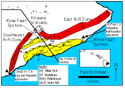
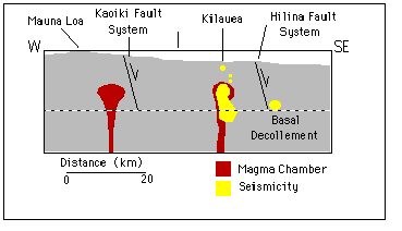
Presently two active volcanoes exist on Hawaii, Mauna Loa and Kilauea. Major geologic features of the south flank of Kilauea Volcano include Kilauea caldera, and the Southwest and East Rift Zones (Figure 1). A decollement surface (Figure 3) is interpreted at depths of 5-10 km, representing an interface between the Pacific oceanic lithosphere
and Hawaiian volcanic edifice (Ando, 1979). The south flank region exhibits concentrated active seismicity and volcanic activity. South flank geologic hazards include seismic and volcanic events, associated tsunamis, and mass movements. Two major normal fault systems, the Koae and Hilina Faults Systems (HFS), trend approximately
northeast-southwest across the south flank. Significant earthquakes have occurred on the south flank in 1823, 1868, 1975, and 1989. Only two historic earthquakes produced displacement along the HFS (Figure 1), 1868
M 7.9 Kau (Clague & Denlinger, 1993) and 1975 M 7.2 Kalapana earthquakes (Tilling et al., 1975; Lipman et al., 1985). On November 29, 1975, the M 7.2 Kalapana earthquake produced maximum south flank displacements of 8 meters seaward and 3 meters vertical subsidence (Lipman et al., 1985). Displacement of the south flank locally generated
a 14 meter high tsunami detected in the western Pacific, Alaska, and California. Total damages in Hawaii from the earthquake and resulting tsunami exceeded $ 4 million (Tilling et al., 1975).
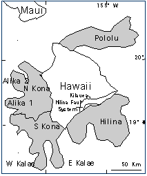
Earthquakes may trigger mass movements of coastal areas on oceanic volcanic islands. Hummocky terrain offshore of the Hawaiian islands (Figure 2) has been interpreted as catastrophic mass movement landslides of the volcanic edifice (Denlinger & Okubo, 1995). Normal faults, such as the HFS, may represent the surface expression of mass
movement slump headscarps.
To begin a paleoseismic analysis of the south flank, this project will focus on surface deformation associated with the 1975 Kalapana earthquake. The 1975 earthquake is the only major Hawaiian historical earthquake where geodetic surveys were conducted before and after the earthquake. A detailed rupture and fault displacement map of the
Kalapana earthquake will be constructed, as no detailed map has yet been produced. Spatial variability of magnitude and orientation of offsets will be analyzed from the fault displacement map to better understand the kinematics of the south flank. In addition to the Kalapana event, earthquake displacements prior to 1975 will be analyzed and dated. Recurrence intervals of south flank earthquakes will be calculated.
Kinematics of the south flank can be addressed by modeling of geodetic data. A controversy exists regarding the depth of faulting in the HFS; faulting could be either shallow or deep. In addition to surface displacement along the HFS, the 1975 Kalapana earthquake hypocenter occurred at 10 km depth and produced a thrust focal mechanism
(southeast transport direction) on a sub-horizontal fault plane dipping ~6 degrees to the north (Ando, 1979). The 1975 Kalapana earthquake is interpreted as a detachment event occurring along the interface between the Pacific oceanic lithosphere and Hawaiian volcanic edifice (see Lipman et al., 1985).
Inferring the HFS as shallow faults (Hill & Zucca, 1987), normal faults with dips of 60-70 at the surface shallow into listric normal faults at depths of 2-3 km (Figure 3a). Headscarps of the HFS represent shallow slump blocks, and surface faults do not directly link with the deeper decollement surface. Listric faults would produce a
northward back-rotation of hangingwall blocks in the HFS. Riley (1996) concludes from paleomagnetic analysis that Puu Kapukapu has been down-faulted and northward back-rotated on a 5 km deep listric normal fault with respect to the Hilina Pali. Seismicity may trigger landslides on shallow HFS normal faults.
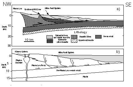
The HFS may be interpreted as surface normal faults descending to 5-10 km depths and forming a splay with the decollement surface (Figure 3b). Seismic slip on the decollement may induce surface displacements on the HFS. P-wave tomographic studies indicate an anomalous velocity gradient at depth in the HFS region (Okubo et al., 1997). They also identify a concentration of microseismicity at the proposed splay junction
of the HFS and decollement faults (Figure 4). These two conclusions provide evidence for the linkage between HFS surface normal faults and the decollement.
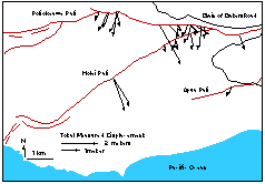
HVO scientists produced summary maps of 1975 Kalapana earthquake contoured vertical and horizontal displacements (Tilling et al., 1975) on a 1:500 000 scale map. These maps are based on geodetic station displacements, not data from individual total displacement measurements along the earthquake rupture of the HFS. Kellogg & Chadwick (1985)
measured fault displacements in the western HFS by traversing fault scarps (Figure 5). Their measurements indicate varied magnitude and direction of total fault displacements from the Kalapana earthquake.
Lava flows originating from Kilauea caldera and rift zones flow over HFS fault scarps. Stratigraphic and 14C methods provide dates for these flows. Stratigraphy of south flank lava flows has been constructed back to approximately 50-100 ka (Easton, 1987; Holcomb et al., 1987),
relative to seven age-dated major ash members. Estimates on the age of the HFS vary, from 23 ka (Pahala Ash) on Puu Kapukapu (Easton, 1978), to 35.8 ka (Pohakaa Ash) on Puu Kapukapu and Hilina Pali (Riley, 1996). Organic material and charcoal originating from plants such as tree ferns and ohia trees can be dated using 14C dating techniques (see Wolfe & Morris, 1996). Assuming these plants were killed by an advancing lava flow, 14C dates can provide an estimated age of the lava flow.
One goal of this project is to produce a detailed fault displacement map of the 1975 Kalapana earthquake. Aerial photographs from 1965 (1:24 000 scale) will be scanned into a computer system and used to identify fault ruptures prior to the 1975 Kalapana earthquake. Several series of aerial photos (1:12 000 - 1985, 1:5 000 & 1:10 000 - 1975, 1:24 000 orthophotoquad-1977) clearly display Kalapana earthquake displacements
in pahoehoe and aa lava flows. These post-earthquake aerial photographs will be interpreted and used to produce an initial Kalapana earthquake trace map.
Field mapping of the Kalapana displacements during Summer 1998 will utilize GPS surveying equipment to produce a detailed fault displacement map. In the east-central region of the HFS, pahoehoe lava flows and proximity to the Chain of Craters Road will allow the use of GPS Real-Time Kinematic (RTK) survey-grade technology. Surface features
can be surveyed with an accuracy of ~1 cm, thus piercing points and surface rupture geometry can be mapped in great detail. In remote regions of the field area, where RTK technology will be difficult to use or create a safety hazard, aerial photos will be used to identify the location of fault displacements, and a mapping-grade GPS receiver (1-5 meter location accuracy) will be used to map locations of fault displacements. Displacements will be measured with nylon tape measures, and attitude of piercing points will be measured with a compass.
As part of the paleoseismic analysis of the HFS, cross-cutting relationships in the lava flows can be used to determine displacements and maximum ages of displacement for previous earthquake events. Lava flows with ages previously determined will be visited and examined for earthquake displacement. If an earthquake fissure displaces a
dated lava flow, a maximum age can be associated with the earthquake event. Lava flow outcrops with organic matter or charcoal will be sampled for later 14 C dating, or possibly uranium-series dating.