
|
|
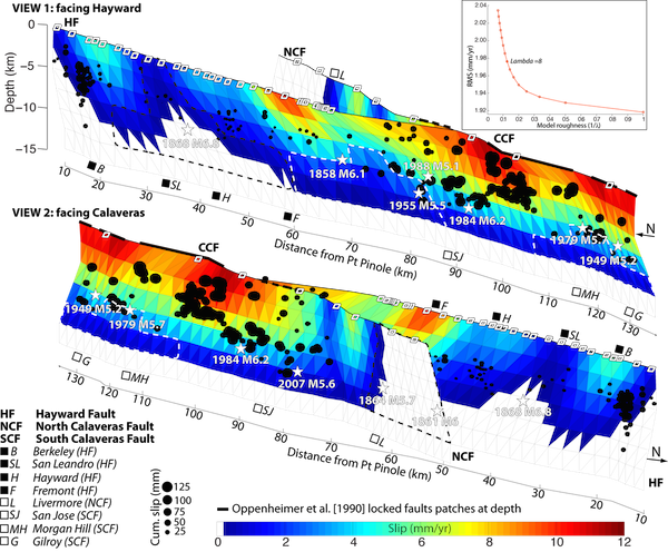
Figure: Model of the slip distribution at depths shallower than the locking depth (12.5km) on the Hayward-Calaveras Fault system (HCFS) from inversion of surface creep. Top view north toward the left (facing Hayward Fault (HF)), bottom view north toward the right (facing Calaveras Fault (CF)). Black dots are repeaters with their size proportional to 1992-2011 cumulative slip, white stars are historical earthquakes locations, and white diamonds show the alignment arrays locations. The black dashed line highlight locked patches (lower than 1mm/yr) and the white dashes lines low slipping patches (lower than 3 mm/yr). The inset on the top right shows the RMS as a function of the Laplacian smoothing factor.
| Project Summary |
Evaluation of interseismic strain accumulation and creep traditionally relies on GPS, alignment arrays, and creepmeters, providing precise, but spatially sparse measurements. Here, we use InSAR to resolve interseismic deformation associated with the Hayward and Calaveras Faults (HF and CF, respectively), in the East San Francisco Bay Area, with a high spatial resolution. We keep InSAR independent from GPS and alignment arrays data and show that a large SAR dataset enables characterization of short and long-wavelength deformation signal as small as 2 mm/yr without the need of aligning the velocity field to GPS-based model of strain accumulation. By implementing an interferogram selection directly based on the spatial coherence, our modified time series approach enables deformation mapping in vegetated areas and leads to refined estimates of along fault-creep rates on the Hayward-Calaveras Fault System (HCFS). We find that the creep varies from ~0 mm/yr on the north CF to ~12 mm/yr on the central CF, the CF reaching its maximum creep rate south of the surface junction with the HF.
We provide a refined characterization of the distribution of locked and creeping patches at shallow depths on the HCFS by inverting the high resolution deformation (Figure). We find that the north CF is mostly locked, explaining the absence of seismicity and find that most of the aseismic slip on the HCFS is limited to the shallowest 5 km, suggesting a partial or full locking at depths of 5-12.5 km, allowing for potential earthquake rupture to nucleate anywhere along the HCFS. Considering the time since the last earthquakes and the difference between the long term slip rates and the shallow slip due to creep (slip-predictable approach) we evaluate that the locked San Leandro patch could produce a M6.4, the locked patch of Livermore a M6.5, and the two slow creeping patches south of Fremont and near Morgan Hill a M6.3 and a M6.1, respectively. Given the direct connection between the HF and CF and the quasi-continuous locking at depths >5 km along the HCFS, we consider the potential for cascading multi-segment ruptures. To this day the HF could produce a M6.9, the north CF a M6.7, the central CF a M6.9, a joined rupture involving the central and north CF a M7.0, and a joined rupture involving the central CF and the HF could produce a M7.1.
|
| Tools | InSAR, Numerical modeling |
| Geographic Location | San Francisco Bay Area, California |
| Project Duration | Summer 2014-Summer 2015 |
| Group Members Involved | Estelle Chaussard, Roland Bürgmann, Christopher W. Johnson, Robert Nadeau, Taka'aki Taira, Ingrid Johanson |
|
|