
|
|
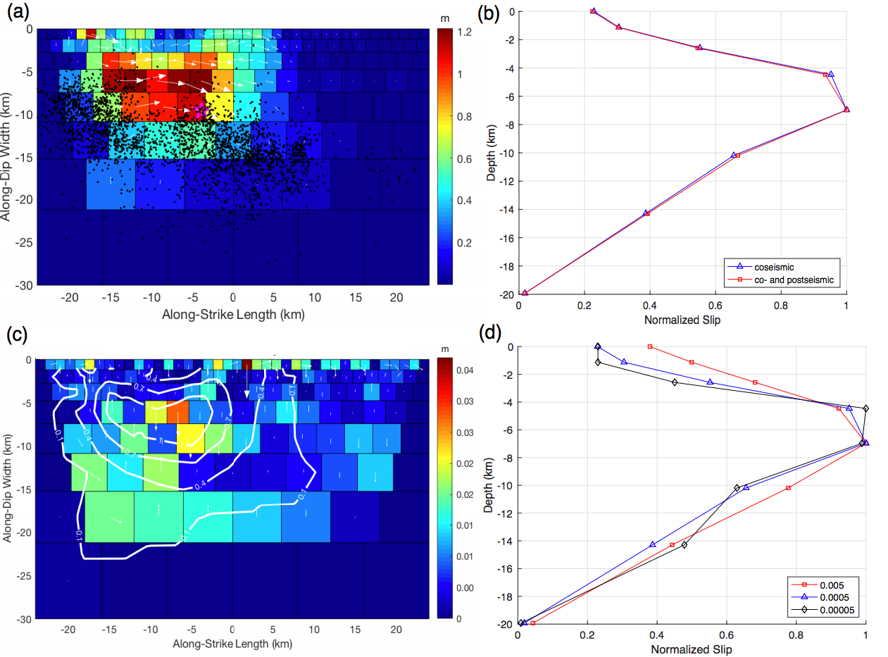
(a) Coseismic slip distribution of 2017 Mw6.5 Jiuzhaigou earthquake derived from Sentinel-1A InSAR data. Color shows the slip in meters. The origin corresponds to the center of the fault’s upper edge, which is at 103.82E, 33.15N. Pink star denotes the hypocenter from USGS. Black dots represent relocated aftershocks within 30 days after the Jiuzhaigou earthquake (Fang et al., 2018). (b) Inverted afterslip based on the cumulative displacement field of both ascending and descending orbit data. (c) Distribution of normalized average coseismic, and of co- plus postseismic slip versus depth, both showing a clear SSD. (d) Distribution of normalized coseismic slip versus depth given different smoothing parameters. The SSD is slightly reduced when more smoothing is applied.
| Project Summary | The Mw 6.5 Jiuzhaigou earthquake occurred on 8 August 2017 36 km WSW of Yongle, Sichuan, China. We use both ascending and descending Sentinel-1 InSAR and coseismic offsets of four GPS sites to obtain the coseismic surface deformation field and invert for the fault geometry and slip distribution. Most slip of the left-lateral strike-slip earthquake occurred in the 3-10 km depth interval with a maximum slip of about 1 m and a large shallow slip deficit (SSD). An 8-month InSAR time series analysis documents a lack of resolvable postseismic deformation. Inversions for the distribution of co- and postseismic slip demonstrate the existence of a SSD and lack of shallow afterslip. We argue that the observations of a pronounced SSD and no early afterslip of the Jiuzhaigou earthquake are indicative of an immature fault and that all incipient young strike-slip faults likely feature a SSD. We would expect complex rupture geometry with distributed coseismic failure in the uppermost part of the brittle crust during the fault zone development. As faults mature, they straighten out, develop a localized fault zone core, and the SSD diminishes. |
| Tools | InSAR, GPS |
| Geographic Location | Tibetan Plateau, China |
| Group Members Involved | Yuexin Li <Email> <Personal Web Site>, Roland Bürgmann, Bin Zhao |
| Project Duration | 2018 - 2020 |
| Reference | Li & Bürgmann, BSSA, 2020 <Link> |