
|
|
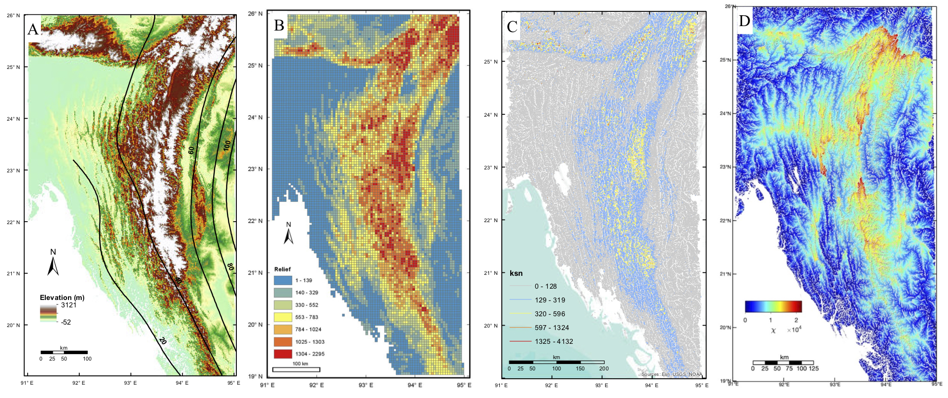
Topography and geomorphic indices of the IBR. (A) Elevation map and slab depth contour (black lines) from SLAB2.0 (Hayes, 2018). (B) Reliefs of individual 5km x 5 km pixels. The warmer colors represent higher relief. (C) Normalized steepness index (ksn) of streams in the IBR. The warmer colors indicate greater ksn values. (D) χ values of streams in the IBR. The greater contrast degree of χ values indicate locations where drainage divides are migrating.
| Project Summary |
The Indo-Burma Range (IBR) is an oblique subduction zone that formed due to the India-Eurasia collision starting in the Paleogene. The highly oblique subduction has produced components of both EW shortening and NS strike-slip deformation (e.g., Steckler et al., 2016). It remains an out-standing question whether the region is still tectonically active with ongoing subduction. To address this knowledge gap, several research groups have studied evidence of ongoing interseismic deformation (i.e., GPS velocities, elastic block modeling, and seismicity) (Socquet et al., 2006; Steckler et al. 2016; and Mallick et al., 2019). We complement these short-term investigations by considering the topographic expression of active tectonics by examining geomorphic indices (i.e., steepness index, stream length gradient and chi) across the IBR and explore dynamic surface models to test how drainages evolve over time in a highly oblique subduction regime. Our preliminary morphometric results suggest a complex structure and support ongoing tectonic uplift distributed across the eastern IBR, especially in areas between the Kabaw and the Churachanpur Mao Faults (CMF). The eastern region is characterized by relatively high elevations, likely due to the greater degree of EW contraction. By comparison, the western IBR (regions west of the CMF) comprises more simple structures (lower-elevation, spaced anticlines) that accommodate less EW contraction, yet the characteristics of the streams, i.e. steep and V-shaped canyons, indicate ongoing tectonic uplift in these areas. We need more data to determine if uplift in the IBR is direct evidence of subduction thrusting or simply documents slip on a large number of broadly distributed active faults and folds without the involvement of an underlying megathrust. In addition, by investigating both short- and long-term processes using a diverse suite of surface measurements, we hope to find the relationship between horizontal contraction and vertical uplift rates and improve our understanding of the active tectonics of the IBR.
|
| Tools | We employ ArcGIS, MATLAB, TopoToolbox, and Google Earth to extract elevation data from the USGS 30 x 30 m SRTM digital elevation model, identify streams and drainage basins, and calculate geomorphic indices. We use LANDLAB to generate the dynamic surface models and compare our modeled results with the observations of topography in the study region. |
| Geographic Location | Indo-Burman Range, the border between Myanmar, Bangladesh and India |
| Group Members Involved |
Patcharaporn "Nam" Maneerat <Email> <Personal Web Site> Roland Bürgmann |
| Project Duration | Sep 2017 - 2020 |
| More Information | < > |
|
|