
|
|
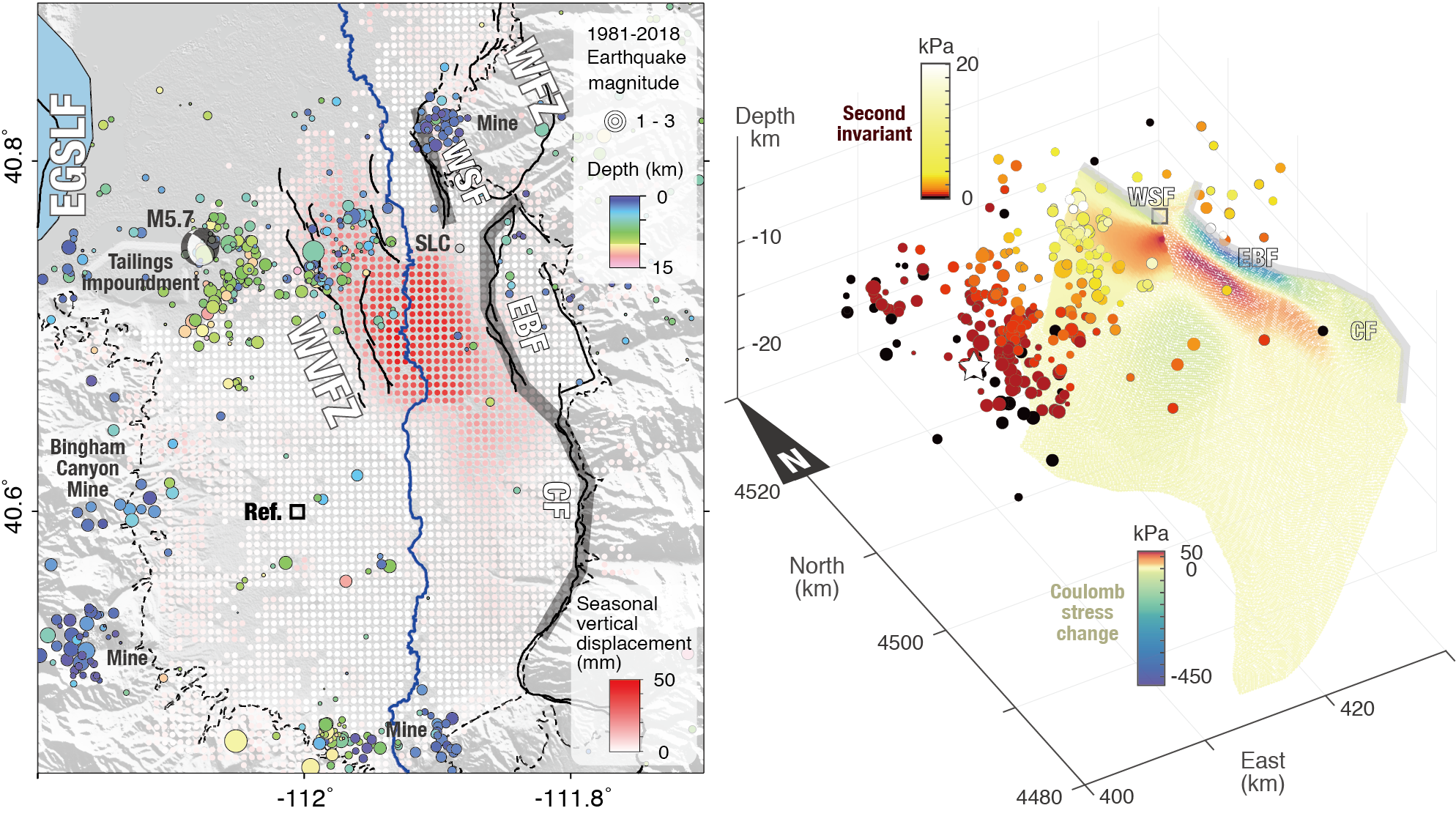
Seasonal ground deformation and aquifer volume-strain and -stress in the seismically active Salt Lake Valley. In the left panel, reddish color represents the seasonal uplift during wintertime. The yellow star denotes the reference area. Earthquake locations during 1981-2018 are shown by circles whose size indicates the magnitude and the color represents the depth. Gray bands show the surface traces of the principal fault segments of the Wasatch Fault Zone around Salt Lake City, including the Warm Springs fault (WSF), East Bench fault (EBF), and Cottonwood fault (CF). The focal mechanism corresponds to the M5.7 earthquake on March 18th, 2020. The white star in the right panel shows its hypocenter. The right panel shows the Coulomb stress change on the WFZ fault planes and the second invariant of stress at each hypocenter (1981-2018) due to volume strain during peak water levels in the spring.
| Project Summary | Aquifers and fault zones may interact through groundwater flow and stress redistribution, yet their spatiotemporal relationship remains enigmatic. Here we quantify changes in water storage and associated stress along the Wasatch Fault Zone in Salt Lake Valley. Ground deformation mapped by Sentinel-1 SAR imagery (2014-2019) reveals an elongated area with ~50-mm seasonal uplift and ~30-mm seasonal horizontal extension in wintertime (reversed for summertime), corresponding to 0.03-0.06-km3 water storage cycles. Phase shifts across active faults in both water level and deformation suggest control by the low-permeability structures. The seasonal stress changes on the adjoining faults from poroelastic volume strain are two orders of magnitude larger than those from hydrological surface loading, but both are small (up to a few kPa) compared to the annual increase of tectonic loading at seismogenic depths. Historic seismic events, limited in number, do not exhibit statistically significant annual periodicity and hydrological modulation of microseismicity or triggering of the recent M5.7 event is not evident. |
| Tools | InSAR, GPS, water level data, Unicycle |
| Geographic Location | Salt Lake Valley, UT |
| Group Members Involved |
Xie Hu <Email> <Personal Web Site> Roland Bürgmann |
| Project Duration | 2018 - 2020 |
| More Information | EPSL article < Hu and Bürgmann, 2020 > |