Regional and Far-Regional Earthquake Locations and Source Parameters using Sparse Broadband Networks: A Test on the Ridgecrest Sequence
Douglas Dreger, Robert Uhrhammer, Michael Pasyanos, Joseph Franck, Barbara Romanowicz
UC Berkeley Seismological Laboratory, Berkeley, CA
In press BSSA: July 31, 1998
Abstract
Events of the 1995 Ridgecrest, California earthquake sequence were located and source parameters were estimated using data recorded by the broadband, high dynamic range instrumentation of the Berkeley Digital Seismic Network (BDSN). The purpose of this study was to investigate the capability of a sparse broadband network at monitoring a region located outside of the network, as will be the case in the monitoring of the Comprehensive Test Ban Treaty (CTBT) for low magnitude seismic events. In addition, we present a case study which is representative of the capabilities of other regional broadband networks. To assess the capability of a sparse network we compared locations estimated from BDSN phase measurements to a "ground truth" catalog of high quality earthquake locations derived from data recorded by the Southern California Seismic Network (SCSN). An adaptive grid search location program that utilizes the timing and azimuth of multiple phase picks from one or more stations was used to determine the importance of the different types of data on absolute event locations. Sparse subnets of BDSN stations in the distance ranges from 250 to 500 km and 500 to 800 km were used. The results indicate that in the regional distance range it is possible to obtain absolute event locations to within 18 km as is prescribed by the CTBT, however in the far-regional distance range the lower signal-to-noise levels precluded the location of the events to within the CTBT objective.
Introduction
Sparse broadband networks often offer the best opportunity to analyze seismic events particularly in those cases in which the event of interest is located far outside the recording network. This will likely be the case in the monitoring of the Comprehensive Test Ban Treaty (CTBT) using the International Seismic Monitoring System (ISMS) for small magnitude events, and for studying earthquakes in the United States using the National Seismic Network (NSN). Sparse broadband networks have recently been deployed in northern and southern California (BDSN and TERRAscope respectively), Mediterranean (MedNet), Japan (FREESIA), and the continental US (USGS NSN), and on a global scale (IRIS GSN). Stations from some of these networks contribute to the International Seismic Monitoring System (ISMS). A key design consideration for the Primary and Auxiliary seismic networks of the ISMS was that these networks be capable of locating events M![]() 4 with an uncertainty of less than 1000 km2, i.e., within a circle of radius less than 18 km. For low-yield explosions or evasively tested nuclear devices the resulting small magnitudes will preclude the recording of signals from IMS stations at teleseismic distances and will necessarily focus the analysis effort at distances of a few hundred to perhaps 2000 km, where lateral heterogeneity in earth structure significantly complicates the problem. The purpose of this paper is to report on our study that evaluated the effectiveness of a sparse broadband network at monitoring a region, and to discuss the modifications to standard processing techniques, which can improve performance. Both location and moment tensor analyses are evaluated in the context of using the Berkeley Digital Seismic Network (BDSN) to monitor a region outside of the network coverage such as southern California. In particular, we focused our analysis on the recent Ridgecrest California sequence in southern California because the prolific aftershock sequence has both large events to provide calibration and small events to test location capability and threshold. BDSN stations are located at distances ranging from 250 to 800 km from the Ridgecrest sequence thereby providing a reasonable test of regional location capability (e.g Figure 1).
4 with an uncertainty of less than 1000 km2, i.e., within a circle of radius less than 18 km. For low-yield explosions or evasively tested nuclear devices the resulting small magnitudes will preclude the recording of signals from IMS stations at teleseismic distances and will necessarily focus the analysis effort at distances of a few hundred to perhaps 2000 km, where lateral heterogeneity in earth structure significantly complicates the problem. The purpose of this paper is to report on our study that evaluated the effectiveness of a sparse broadband network at monitoring a region, and to discuss the modifications to standard processing techniques, which can improve performance. Both location and moment tensor analyses are evaluated in the context of using the Berkeley Digital Seismic Network (BDSN) to monitor a region outside of the network coverage such as southern California. In particular, we focused our analysis on the recent Ridgecrest California sequence in southern California because the prolific aftershock sequence has both large events to provide calibration and small events to test location capability and threshold. BDSN stations are located at distances ranging from 250 to 800 km from the Ridgecrest sequence thereby providing a reasonable test of regional location capability (e.g Figure 1).
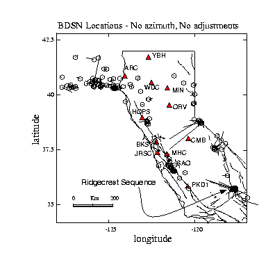
Figure 1. Map showing the locations of BDSN station (triangles), northern California control events (hexagons) with mislocation vectors describing the relative locations when only P and S arrival time information is use. The northern California control locations utilized phase picks from BDSN and the northern California Seismic Network (NCSN). Within BDSN the location capability is very good and outside the network mislocations become large. The Ridgecrest sequence in southern California is the focus of the present study.
Methodology
Event locations reported in the SCSN Earthquake Catalog distributed by the Southern California Earthquake Center (SCEC) are used as "ground truth." These locations are obtained from phase arrivals recorded by SCSN, which consists of more than 350 analog and digital instruments located throughout southern California. The Ridgecrest events used in this study (Table 1) are located to within a circle of radius 4-km and therefore will provide an excellent basis from which to test the capabilities of the BDSN network. All of the events in Table 1 are reported as quality A which have sub-kilometer location errors both laterally and in depth (e.g. Given et al., 1987). Because the events are so closely located they essentially have the same propagation path at regional and far-regional distances. Therefore, the effects of lateral heterogeneity on the waveforms for each event should be the same and our analysis can focus on the effects of picking bias, methodology and calibration.
To examine the location capability of the sparse BDSN network three analysts independently made P, S and azimuth measurements, and computed station adjustments. Each analyst was instructed to make consistent phase picks, and to use the two largest events in the Ridgecrest sequence (Table 1) to derive average station adjustments for P, S, and azimuth. No instruction as to which regional phase to pick was given. One analyst chose to use the Sn arrival and the other two used higher frequency, later arriving, phases. All three picked the first arriving Pn phase. Azimuth was estimated from either Pnl or Love waves. The events were then located using combinations of different types of information to assess absolute location quality relative to the "ground truth" catalog. From our earlier work (Figure 1; Dreger et al., 1996) we knew that the linearized, iterative location algorithm we routinely employ (e.g. Canas et al., 1977) needed to be improved for sparse network configurations. In this work we have used a newly developed location program which specializes in sparse network geometry, and is discussed in the next section.
The three analysts performed a number of event location simulations to test the importance of various types of observations, such as P and S arrival times, wave propagation azimuth, and network geometry on absolute location quality. Generally the results of each of the analysts were very similar and in the interest of brevity we will only present the results from analyst one.
Analyst one used phase measurements from at most 6 stations, and for most events 4 or fewer of the closest stations were used (e.g. CMB, MHC, PKD1, and SAO). In addition, only two stations (PKD1 and CMB) were used to measure azimuth. A gradient over a half-space approximation to the SoCal model of Dreger and Helmberger (1993) was used to compute P and S arrival times, where
![]()
a , b , and z are the P- and S-wave velocities (km/s), and depth (km), respectively.
The phase measurements were made on broadband (0.01 to 10 Hz) displacement or velocity data and azimuth measurements were performed on low-pass filtered (four pole, zero-phase, Butterworth filter, with a corner of 0.10 Hz) displacement data. Determining the azimuth in this manner was relatively easy and we estimated that our measurement resolution is on the order of ± 3o. The measurement resolution is independent of the systematic adjustments that are needed due to the heterogeneity of the Earth’s crust.
Table 1 - SCSN Earthquake Catalog Locations
|
Year.doy |
Origin time |
Latitude (N) |
Long. (W) |
Depth (km) |
Magnitude |
ID number |
|
1995.229 |
22:39:59.00 |
35.776 |
117.662 |
5.6 |
5.4* |
95-078 |
|
1995.242 |
15:29:54.62 |
35.791 |
117.641 |
5.0 |
4.2 |
95-102 |
|
1995.242 |
15:54:22.46 |
35.796 |
117.640 |
3.4 |
4.0 |
95-103 |
|
1995.243 |
01:58:58.78 |
35.793 |
117.644 |
5.2 |
3.9 |
95-104 |
|
1995.254 |
18:37:23.75 |
35.788 |
117.662 |
6.6 |
4.2 |
95-112 |
|
1995.263 |
23:27:36.22 |
35.756 |
117.630 |
5.4 |
5.5* |
95-114 |
|
1995.263 |
23:56:58.50 |
35.780 |
117.666 |
5.3 |
3.9 |
95-119 |
|
1995.264 |
07:46:53.65 |
35.759 |
117.637 |
5.1 |
3.9 |
95-128 |
|
1995.264 |
07:57:41.34 |
35.756 |
117.633 |
5.4 |
4.0 |
95-129 |
|
1995.264 |
14:11:06.85 |
35.743 |
117.634 |
5.4 |
3.5 |
95-131 |
|
1995.264 |
23:48:39.16 |
35.761 |
117.643 |
5.4 |
4.0 |
95-133 |
|
1995.267 |
13:15:30.04 |
35.791 |
117.660 |
6.3 |
3.7 |
95-136 |
|
1995.268 |
04:21:40.60 |
35.808 |
117.618 |
8.8 |
3.5 |
95-137 |
|
1995.268 |
04:47:29.18 |
35.809 |
117.616 |
9.4 |
4.9 |
95-138 |
|
1995.271 |
11:36:28.37 |
35.810 |
117.640 |
4.4 |
3.5 |
95-145 |
|
1995.275 |
00:10:53.59 |
35.809 |
117.646 |
4.7 |
3.8 |
95-150 |
|
1995.279 |
19:15:04.26 |
35.758 |
117.636 |
5.4 |
3.6 |
95-157 |
|
1995.284 |
14:45:35.14 |
35.799 |
117.633 |
5.1 |
3.5 |
95-160 |
|
1995.291 |
12:42:04.80 |
35.742 |
117.631 |
3.7 |
4.1 |
95-163 |
|
1995.291 |
12:49:07.49 |
35.742 |
117.634 |
5.1 |
3.8 |
95-164 |
|
1995.336 |
00:29:08.63 |
35.784 |
117.687 |
5.8 |
3.7 |
95-182 |
|
1996.007 |
14:32:54.10 |
35.769 |
117.643 |
5.8 |
5.2 |
96-001 |
|
1996.008 |
10:52:28.90 |
35.780 |
117.640 |
5.1 |
4.3 |
96-002 |
Origin time is UTC. Magnitudes are as reported by SCEC and may be either duration or ML. * denotes calibration events.
Broadband Waveform Regional Earthquake Location Program (BW-RELP)
To improve the sparse network locations a new program, herein referred to as BW-RELP, was developed to make use of multiple phase picks and azimuth information. The details of this program will be discussed in a forthcoming paper, however it is useful to briefly describe its operation here. An adaptive grid search technique was used providing a level of flexibility that would be difficult to achieve with a standard inverse approach. For example, this code allows for path dependent velocity models, station adjustments, and azimuth corrections. Flexible misfit norms can be used to analyze the effect that outlying observations have on a solution. An adaptive grid search scheme allows more control of the differential weighting of the various traveltime and azimuth data. The adaptive grid search is also more amenable to the incorporation of 3D velocity models because it is not necessary to compute complicated partial derivatives. BW-RELP searches over latitude, longitude, depth, and origin time. In our calculations we fixed the depth at 8 km since the events are located far from the stations and we did not pick depth phases to help constrain source depth. The value of 8 km was chosen since it is representative of an average source depth in California. The average hypocentral depth of the events in Table 1 is 5.5 km. The range of latitude and longitude was several degrees each encompassing the Ridgecrest and surrounding region. For several events a search area spanning the entire state of California and parts of Nevada and Arizona was tested, and the results from those experiments revealed that there was a single minimum centered in the Ridgecrest area.
The misfit function that is used in BW-RELP is defined as,
 ,
,
where P is the misfit value, l is a parameter that provides relative weighting between travel time and azimuth residuals. The code utilizes only traveltime information if l =0 and only azimuth information if l =1. d r is the traveltime residual which is cast in terms of a distance metric (d r = d t * metric) to provide a straight forward comparison to the arc length D d j . d j is the azimuth residual and D is the distance to a station. The metric is set to an average seismic wave velocity such as 6 km/s. nt and nj are the number of time picks and azimuth picks, respectively. The norm can range between 0 and ¥ . Values of 1 and 2 correspond to the L1 and L2 norms, respectively. In our calculations we set norm to 1.25 following Kennett (1996). The summation is performed for n phase readings where the phase readings can be either P or S arrival times or wave azimuth.
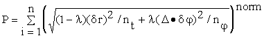
With the grid search algorithm it is possible to map out the parameter space in order to analyze the resolution and uncertainty of a given calculation. For example, Figure 2a shows how the adaptive grid search procedure converges. The procedure is adaptive in the sense that if the best location lies near the edge of a grid the grid will creep rather than contract. When the minimum is toward the center the dimension of the grid shrinks and the sampling density increases as is shown in Figure 2a. Figures 2bcd show how the resulting parameter space changes with the addition of various types of waveform information. The calculation using only P arrival times is clearly poorly resolved. The addition of S-wave arrival times and Pnl azimuth determined from particle motions of the three-component broadband data serves to reduce the size of the minimum as well as provide a better location in the absolute sense. The addition of both traveltime and azimuth station adjustments are needed to focus the event onto the control location.
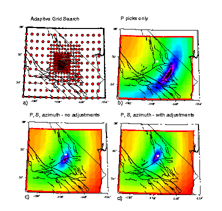
Figure 2. (a) Example of an adaptive grid search. The circles show the specific locations that were tested. The grid shifts and contracts as the method converges. b) Plot showing ln(P) for the case in which only P arrival times are used. c) ln(P) when P, S, azimuth with no adjustments are used. d) same as c) with traveltime and azimuth station adjustments applied. In all cases the white circle shows the "ground truth" location. The full color range spans a range of 102.5 in P.
The parameter space contains all of the information needed to estimate the precision of the solution. There is no direct mapping to standard error measures and there is no guarantee that the parameter space will have an ellipsoidal shape. In fact, Figure 2 shows that it does not in some of the cases. Therefore, to provide an estimate of solution precision, travel-time and azimuth residuals are cast into a common distance metric that is then used to map the uncertainty surface around the global minimum. This is done by calculating the standard deviation of the travel-time residuals (sd ), and then perturbing the origin time by either ± sd for a normal measure of uncertainty and by ± 2sd for a 95% confidence surface. P95 defines such a ± 2sd precision surface in 4-dimensional space around the global minimum. P95 is considered a better measure of the location precision because it accounts for the distortions from an idealized elliptical error surface. For example, as Figure 2 shows, the shape of the minimum is generally different from a simple ellipsoid, which is due to the geometry of the observing network.
Analysis of Event Locations
The Ridgecrest events located using only BDSN phase picks and a linearized traveltime inverse procedure without adjustments were found to have large absolute mislocations, in some cases exceeding 100 km. These mislocation errors can be either in the direction toward or away from the recording network as shown in Figure 1. In the former case the mislocation error is likely to be due to a bad phase pick at a station with considerable weight in the inversion, and the nature of a locally linearized inverse procedure. In the later case it is a characteristic origin-time distance tradeoff. Because the phase measurements used in Figure 1 were made over the course of one year, the consistency in the picks is not as good as they are in this paper where the measurements were made over several days.
In Figure 3 we compare the absolute event locations obtained using BW-RELP with various combinations of phase and azimuth observations. Panel one compares the event locations that are obtained when only P phases are used. Generally, the events are distributed along a vector pointing away from the BDSN stations which is characteristic of an origin-time/distance tradeoff. The inclusion of azimuth information, and static travel-time and azimuth station adjustments (panel two), improves the locations in terms of decreasing event cluster size and in terms of centering the events on the ground truth location.
Figure 3. Event location maps for Analyst 1 comparing the effects that the different combinations of phase, azimuth and adjustment information have on absolute locations. The "ground truth" locations all plot within a square one-half the size shown.
Panel three compares the absolute locations when both P and S phase readings are used, and panel four shows a blow up of the epicentral region. The large circle shows the 1000 km2 target region (18-km radius). The inclusion of S phases greatly reduces the origin-time/distance tradeoff and focuses the events into a circular distribution rather than the linear trend characteristic of the P wave only calculations. The event distribution shown in panels three and four are the result of careful, consistent phase picking, which was done sequentially over a period of several days. The phase picks in Figure 1 were made over the course of the year, as the events occurred. The inclusion of azimuth information (panel five) improves the clustering of the events and slightly reduces the absolute mislocation of the cluster. Although the dimension of the event distribution is greatly reduced the absolute mislocation relative to "ground truth" can remain large. For example, the centroid of the distribution in panel 5 is 36.7 km from the centroid of the control catalog (center of the large circle). The dimension of the distribution is large and a significant number of events lie more than 20 km from the distribution centroid. The average P95 error in latitude and longitude are 19 km. Thus a number of events may have P95 errors which do not overlap the "ground truth" location. Recall that P95 is simply a surface, which describes the range of locations for which the calculated travel-times fit the data to within 2sd of the travel-time residuals. Of course, it is not necessary that P95 or conventional standard errors overlap with the absolute location because of unknown errors due to the 3D Earth being approximated by assumed 1D velocity models. As panel six shows, it is the incorporation of traveltime and azimuth station adjustments that focuses and tightens the event distributions onto the true location.
It is remarkable that the locations, obtained using only a few stations with very limited aperture, are as good as shown in Figure 3. It is important to note however that if you examine the performance binned over magnitude there are still mislocations exceeding the CTBT goal of absolute errors of less than 18 km (Figure 4). Nevertheless, Figure 4 shows that it is possible to achieve absolute event location accuracy of better than 18 km to a low magnitude of 3.5. With further calibration and review of picks it is likely that all of the events above magnitude 4.0 could be located to within 18 km of "ground truth".
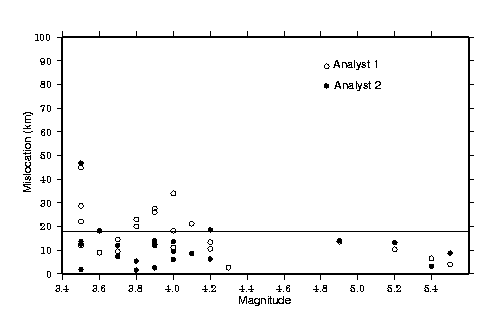
Figure 4. Mislocation relative to "ground truth" is plotted as a function of magnitude. Open circles show absolute mislocation obtained by two of the analysts. The horizontal line marks the 18 km level corresponding to a location accuracy of 1000 km2.
Figure 5 details the improvements for two events of magnitude 4.2 (95-102) and 3.5 (95-131). The histogram shows that the addition of azimuth information greatly reduces the level of mislocation especially when only P arrival time and azimuth are included. The best locations are obtained when azimuth and S-wave picks are used. To obtain locations within a radius of 18-km of ground truth it is necessary to apply static travel-time and azimuth station adjustments. Note that even with the adjustments applied it was not possible to locate the M3.5 event (95-131) within a radius of 18 km of ground truth.

Figure 5. Histogram showing the improvement in absolute mislocation for two events. The event information is listed on Table 1. The horizontal line defines the 18-km mislocation level. Note that the absolute mislocation is generally greater for the smaller event presumably due to reduced signal-to-noise quality. The addition of first azimuth measurements, and then S picks and travel-time and azimuth adjustments, systematically reduces the magnitude of the absolute mislocation.
The previous test is representative of the geometry presented to BDSN, TERRAscope and the NSN for regional events, however it is still a very favorable monitoring geometry in the context of the CTBT and ISMS. Another test that is more representative of future CTBT monitoring situations for small magnitude events repeats the previous experiment using only stations CMB, MHC and SAO, thereby reducing the aperture of the network to 30o. The same station adjustments were employed. In Figure 6 we compare the location maps obtained by analysts 1 and 2. The events are still well clustered, however they are not as tightly grouped as in panel six on Figure 3. The mislocation vs. magnitude plot (Figure 6b) shows that many events lie below the 18 km CTBT objective, however quite a few of the low magnitude events have absolute mislocations greater than 18 km.
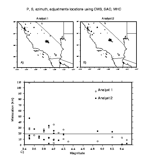
Figure 6. a) Map showing analyst-1 event locations when only three stations are used. Triangles show the locations of the stations. P and S arrival times, azimuth and station adjustments measured at CMB, MHC and SAO were used. b) Same as a) for analyst 2. c) The absolute mislocation relative to "ground truth" plotted against magnitude is compared for analysts 1 (open circles) and 2 (filled circles). The horizontal line marks the 18 km mislocation level.
Figure 7 shows the results using P, S and azimuth picks that were obtained from only the far-regional stations, HOPS, CMB, WDC and YBH. In this case station adjustments were derived from event 95-078 (Table 1). There is a marked improvement with the addition of the station adjustments however all of the events tested are located further than 18 km from "ground truth." The P95 surface intersects the "ground truth" location for only 3 of the 6 events tested. At these far-regional distances it is difficult to consistently pick the first arriving P wave which is a low amplitude Pn arrival. Although it was not examined further in this study it may be possible to improve on the far-regional locations by picking later larger amplitude arrivals and employing the appropriate static station adjustments. Furthermore, it is anticipated that an additional station between 500-800 km at a different azimuth would greatly improve the results. In any case the degradation of the locations due to decreased signal-to-noise levels indicates that arrays would be very useful for identifying both first arrivals in noisy far-regional data and for estimating the propagation azimuth at far-regional distances.

Figure 7 a) Map showing the locations (circles) obtained using P, S and azimuth picks from stations HOPS, CMB, WDC and YBH. The small square shows the aftershock area from the SCEC control catalog. b) Same as a) with traveltime and azimuth station adjustments applied. The filled circle shows the 1000 km2 area surrounding the Ridgecrest source region.
In the above we have restrained the source depth of all events to 8-km. This was done because the closest station used in our analysis lies at a distance more than a factor of 30-50 of the average source depth of the sequence. The method used in this study as with any other location procedure that utilizes only direct arrival times cannot accurately determine source depth with such a sparse network. The moment tensor calculations in the following section demonstrate how source depth may be obtained from long period waveform data of a sparse network. It may be possible to constrain source depth if depth sensitive phases such as pP, sP and sPmP can be identified in the data, and adequate station adjustments could be determined. This is beyond the scope of this paper whose purpose is to demonstrate the level of performance that might be expected at regional and far-regional distances using standard event location practice.
Seismic Moment Tensors
A time domain inverse procedure (e.g. Dreger and Romanowicz, 1994; Pasyanos et al., 1996) was used to estimate the seismic moment tensor of events listed in Table 1. The three component data was integrated to displacement and band pass filtered between 0.02 to 0.05 Hz. In this pass-band the average one-dimensional models that we employ perform quite well in the modeling of the data. For example as Figure 8 shows we are able to fit the data for the three events with greater than 80% variance reduction. Table 2 lists the moment tensor inversion results, and Figure 9 plots the moment tensor results in map view. Only three stations, namely CMB, PKD1 and SAO were used, however for a number of events one or more stations had to be removed due to poor signal to noise ratios. In these cases the PAS and PFO TERRAscope stations were used to improve the station coverage, and in every case the combined BDSN & TERRAscope solution compared very well with the BDSN only result. Still in other cases it was not possible to estimate the moment tensor using only the BDSN. The lower threshold appears to be in the M3.8 to 3.9 range, and it depends on the background noise level of a given day and the distance to the stations used.
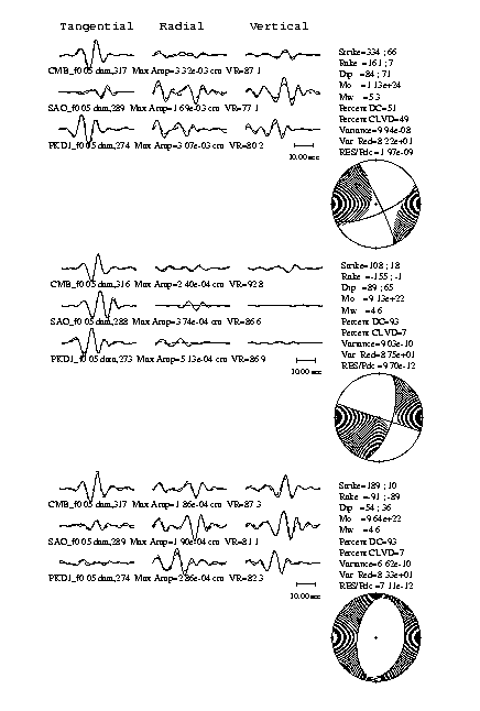
Figure 8. Compares the level of fit between low frequency data (solid) and synthetic (dashed) for three representative events of the Ridgecrest sequence. Note that the locations of both SH and P-SV nodes differ for the three events and that the differences in the focal mechanisms are strongly supported by the waveforms.

Figure 9. Map showing the locations of events from the SCSN Earthquake Catalog and seismic moment tensors obtained by inverting low frequency waveforms recorded at BDSN stations CMB, PKD1 and SAO.
Table 2 shows that the Ridgecrest sequence consists of quite diverse focal mechanisms, although the predominant mechanism is right-lateral slip on a northwest trending plane. The seismicity located at the southwestern edge of the sequence appears to align with the northwest trending nodal plane (Figure 9). Other mechanisms appear to be associated with different clusters of seismicity
The agreement between data and synthetic is quite good in the 0.02 to 0.05 Hz pass-band, and the variation in the resulting focal mechanisms is supported by significant differences in the low frequency waveforms. In cases where independent estimates of the seismic moment tensor were available from either surface waves (Hong Kie Thio, written communication) or broadband waveforms (Lupei Zhu, written communication) the agreement is quite good with our sparse station results. Additionally, the first motion results for the three largest events in 1995 as reported by Hauksson et al. (1995) are in good agreement with our moment tensor results. The first-motion data indicate that the mainshock (event 95-078, Table 1) initiated as a normal event however the waveforms indicate that the earthquake evolved into strike-slip faulting (e.g. Hauksson et al., 1995; this study).
Table 2 - Moment Tensor Solutions
|
|
Origin time |
Magnitude |
Seismic |
|
|
|
|
ID |
|
|
Year.doy |
(UTC) |
SCEC |
MW |
M0 ( |
Strike |
Dip |
Rake |
Depth |
number |
|
1995.229 |
22:39:59.00 |
5.4 |
5.3 |
1.20 |
333 |
88 |
160 |
14 |
95-078 |
|
1995.242 |
15:29:54.62 |
4.2 |
4.4 |
0.0535 |
0 |
40 |
-136 |
5 |
95-102 |
|
1995.242 |
15:54:22.46 |
4.01 |
4.1 |
0.0146 |
27 |
35 |
-80 |
5 |
95-103 |
|
1995.243 |
01:58:58.78 |
3.91 |
3.8 |
0.00666 |
351 |
65 |
175 |
8 |
95-104 |
|
1995.254 |
18:37:23.75 |
4.2 |
4.0 |
0.0106 |
162 |
49 |
-144 |
8 |
95-112 |
|
1995.263 |
23:27:36.22 |
5.5 |
5.6 |
2.38 |
334 |
72 |
-169 |
8 |
95-114 |
|
1995.263 |
23:56:58.50 |
3.9 |
- |
too noisy |
- |
- |
- |
- |
95-119 |
|
1995.264 |
07:46:53.65 |
3.91 |
3.7 |
0.00463 |
144 |
86 |
177 |
5 |
95-128 |
|
1995.264 |
07:57:41.34 |
4.01 |
3.9 |
0.00764 |
145 |
71 |
-160 |
5 |
95-129 |
|
1995.264 |
14:11:06.85 |
3.5 |
- |
too noisy |
- |
- |
- |
- |
95-131 |
|
1995.264 |
23:48:39.16 |
4.02 |
4.1 |
0.0153 |
169 |
87 |
177 |
8 |
95-133 |
|
1995.267 |
13:15:30.04 |
3.7 |
- |
too noisy |
- |
- |
- |
- |
95-136 |
|
1995.268 |
04:21:40.60 |
3.5 |
- |
too noisy |
- |
- |
- |
- |
95-137 |
|
1995.268 |
04:47:29.18 |
4.9 |
4.6 |
0.0910 |
108 |
89 |
-155 |
14 |
95-138 |
|
1995.271 |
11:36:28.37 |
3.5 |
|
too noisy |
- |
- |
- |
- |
95-145 |
|
1995.275 |
00:10:53.59 |
3.81b |
3.8 |
0.00651 |
356 |
36 |
-90 |
5 |
95-150 |
|
1995.279 |
19:15:04.26 |
3.6 |
- |
too noisy |
- |
- |
- |
- |
95-157 |
|
1995.284 |
14:45:35.14 |
3.5 |
- |
too noisy |
- |
- |
- |
- |
95-160 |
|
1995.291 |
12:42:04.80 |
4.1 |
- |
too noisy |
- |
- |
- |
- |
95-163 |
|
1995.291 |
12:49:07.49 |
3.8 |
- |
too noisy |
- |
- |
- |
- |
95-164 |
|
1995.336 |
00:29:08.63 |
3.7 |
3.7 |
0.00414 |
171 |
76 |
-145 |
8 |
95-182 |
|
1996.007 |
14:32:54.10 |
5.2 |
5.1 |
0.587 |
333 |
75 |
178 |
8 |
96-001 |
|
1996.008 |
10:52:28.90 |
4.3 |
4.6 |
0.096 |
10 |
36 |
-89 |
5 |
96-002 |
1. PKD too noisy. Stations CMB, SAO, PAS, and PFO were used. The solutions compare well with that obtained using only CMB and SAO.
1b. PKD too noisy. Stations CMB and SAO were used. The TERRAscope stations PAS and PFO were too noisy to include in the inversion.
2. PKD and SAO too noisy. CMB, PAS and PFO were used. The solution compares very well with what is obtained when only CMB is used.
3. Units are dyne cm.
As reported by Dreger and Helmberger (1993) the time-domain moment-tensor method employed in this paper is insensitive to lateral mislocation of the hypocenter. In Dreger and Helmberger (1993) it was reported that in the Press-Ewing (30-90) pass-band lateral mislocations of 15 km could be tolerated. In the 0.02 to 0.05 Hz pass-band used in this paper the magnitude of tolerable mislocation is substantially greater. For example, when event 95-078 is inverted using the location in panel 5 of Figure 3 (a 35 km mislocation to the SE) the following solution is obtained: strike=339o, dip=88o, rake=173o, depth=8 km, and Mo=![]() dyne-cm. This solution is within 10% of the seismic moment of the solution in Table 2. The maximum deviation is 13o in rake and 6 km in depth. In another case event 95-150 had a 54-km absolute mislocation from "ground truth" when station adjustments were not employed. This mislocation translates to a maximum of 24-km error in source-station distance to CMB and a 9o error in azimuth to the PKD1 station. Nevertheless, a solution of strike=358o, dip=25o, rake=-128o, depth=5 km and Mo=
dyne-cm. This solution is within 10% of the seismic moment of the solution in Table 2. The maximum deviation is 13o in rake and 6 km in depth. In another case event 95-150 had a 54-km absolute mislocation from "ground truth" when station adjustments were not employed. This mislocation translates to a maximum of 24-km error in source-station distance to CMB and a 9o error in azimuth to the PKD1 station. Nevertheless, a solution of strike=358o, dip=25o, rake=-128o, depth=5 km and Mo=![]() dyne-cm was obtained. This represents a 38o change in the rake angle, however the predominantly normal nature of this event is preserved. Velocity models need to be relatively well calibrated to essentially explain the average P and S wave velocities and crustal thickness. If the model is not calibrated unreliable results may be obtained from a sparse network. In California only two velocity models are needed; one for the region west of the coast ranges thrust, and the other for the Sierra Nevada and southern California (e.g. Pasyanos et al., 1996).
dyne-cm was obtained. This represents a 38o change in the rake angle, however the predominantly normal nature of this event is preserved. Velocity models need to be relatively well calibrated to essentially explain the average P and S wave velocities and crustal thickness. If the model is not calibrated unreliable results may be obtained from a sparse network. In California only two velocity models are needed; one for the region west of the coast ranges thrust, and the other for the Sierra Nevada and southern California (e.g. Pasyanos et al., 1996).
Conclusions and Discussion
The results of our analysis of the Ridgecrest sequence reveals that it is possible to obtain event locations with better than 18 km accuracy using a sparse network of regional distance broadband, three-component stations to magnitudes as low as 3.5. However as Figure 4 shows substantial mislocations result for some events less than magnitude 4.1. The consistency of the phase picks achieved by analyzing all of the waveforms at one time leads to better relative event locations, and the calibration of travel-time and azimuth adjustments leads to low absolute mislocation. The lower threshold of course depends upon the ambient background noise level and other regions of interest may have higher or lower thresholds. Large absolute mislocations were obtained in the very sparse network experiment (Figure 7) indicating that better calibration and phase picks would be needed to obtain the desired accuracy level, although another station in the far-regional distance range, but at a different azimuth would be expected to improve the results. Generally, the addition of azimuth information from a few stations greatly improved the clustering of the event locations. Finally, our best locations were obtained using station adjustments obtained from two large calibration events. Without such adjustments the best that we did is shown in panel 5 of Figure 3. While many of the events in this case are located fairly well in terms of the small size of the P95 error, the cluster centroid is 36.7 km from "ground truth" and there are many individual events that fall outside of the 18-km accuracy level. For the far-regional cases all of the events fell outside the desired accuracy goal. Thus in regions with few calibration events large absolute mislocation errors may be expected. This is true when standard errors of locations are small because of systematic errors due to the assumed velocity model. As we have demonstrated, however, it is possible to "bootstrap" from large mainshocks that are well located from regional (or global) networks in order to calibrate paths and locate smaller events. In regions that lack such calibration events large absolute mislocations may be anticipated, although more uniform azimuthal coverage than used in this study would be expected to improve uncalibrated results. The addition of S-waves factored considerably in the improvements of the locations we obtained. In the case of nuclear explosions this may pose a problem however it should be possible to use other regional phases such as Rayleigh waves given proper calibration.
It was possible to estimate the seismic moment tensor of events to a low magnitude of MW 3.7. We used three stations in the moment tensor analysis. The closest station PKD1 was located at a distance 250 km and was also the noisiest of the three stations. For the low magnitude events PKD1 was typically removed and only CMB or SAO (both at a distance of 350 km) were used except where noted on Table 2. The moment tensor solutions presented in this paper compare well with the results of other groups who used surface waves and broadband waveforms recorded by the TERRAscope network. Absolute errors in source-station distance of 35 km and azimuth of 9o were found to not significantly degrade the moment tensor results.
Acknowledgments
We wish to thank two anonymous reviewers for their constructive comments that improved the clarity of this paper. This work in contribution number 98-X of the Berkeley Seismological Laboratory, and was partially supported by the Lawrence Livermore National Laboratory through the Department of Energy’s Comprehensive Test Ban Treaty Research and Development (CTBT R&D) Program, under the Inter-University (IUT) Agreement No. B331608.
References
Canas, J., R. D. Miller, R. A. Uhrhammer (1977). Bulletin of the Seismographic Stations, vol. 47, no. 1, 55 pp.
Dreger, D. S. and D. V. Helmberger (1993). Determination of source parameters at regional distances with single station or sparse network data, J. Geophys. Res., 98, 8107-8126.
Dreger, D. and B. Romanowicz (1994). Source Characteristics of Events in the San Francisco Bay Region, USGS Open-file report, 94-176, 301-309.
Dreger, D., M. Pasyanos, R. Uhrhammer, B. Romanowicz and A. Ryall, (1996). Evaluation of the performance of broadband networks and short-period arrays in global monitoring, Proceedings of the 18th Annual Seismic Research Symposium on Monitoring a CTBT, PL-TR-96-2153, 704-713.
Dreger, D., M. Pasyanos, R. Uhrhammer, J. Franck, and B. Romanowicz (1997). Evaluation of the Performance of Broadband Stations and Regional Arrays in Global Monitoring - Phase II Final Report, submitted July 1997, 10 pp.
Given, D., K. Hutton, and L. Jones, (1987). The Southern California Network Bulletin: July - December, 1986, USGS Open-File Report 87-488, 43 pp.
Hauksson, E., K. Hutton, H. Kanamori, L. Jones, J. Mori, S. Hough, G. Roquemore (1995). Preliminary Report on the 1995 Ridgecrest Earthquake Sequence in Eastern California, Seism. Res. Lett., 66, 54-60.
Kennett, B. L. N., (1996). Event location and source characterization, in Monitoring a Comprehensive Test Ban Treaty, eds E. S. Husebye & A. M. Dainty, Kluwer Academic Publishers, 501-520.
Pasyanos, M.E., D.S. Dreger, and B. Romanowicz, Toward Real-Time Estimation of Regional Moment Tensors, Bull. Seism. Soc. Amer., 86, 1255-1269, 1996.