
Global Positioning System & Geodesy
|
|
Global Positioning System & Geodesy |
 The science of locating points on the earth's surface is called geodesy. Thanks to advances in satellite technology, geodesy has changed dramatically in the last decade with the development of GPS, the Global Positioning System. With special research grade GPS equipment we can locate a point on earth to within a few millimeters (about half the size of a US dime).
The Active Tectonics Group uses GPS to help understand movement along active faults and the plate tectonic processes that cause earthquakes. On the simplest level, we measure the same point on the ground year after year and see how much it moves. If there were no geologic activity the point should be at the same position every year. In tectonically active areas like the Bay Area, the Himalaya, Hawaii, or many other locations this is almost never the the case. Using an understanding of the physical properties of the earth's crust, we perform calculations based on our observations of motion at the earth's surface to constrain the amount of movement several kilometers beneath the surface where earthquakes are generated and faults slip. Since these movements are so small (usually less than a few centimeters a year) we require extremely precise methods for determining the locations.
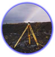
Unlike the handheld GPS receivers available for as cheap as $100, our research GPS receivers require several steps before we can determine our location. Many of the points we survey in our annual "campaign" are on public land but we must always obtain permission to survey points from the appropriate public agency or private landowner. We take great care to set up the antenna exactly on top of the reference mark so that we know that we are surveying the exact same spot that we surveyed in prior years. Once the receiver and antenna are in place we usually collect GPS data for an entire day. We then take the receiver back to our labs where we use specially designed software to turn the day's worth of observations into a single, extremely precise position. That position is then compared to the position from previous surveys and we determine the velocity of that point -- how fast is that particular spot moving with respect to some fixed reference point.
Once we have surveyed several stations over several years, we are able to put together a picture of how the earth's surface is moving in response to faults. With the use of advanced modeling we can determine the behavior of faults below the surface.
For more information about how we use GPS, visit our Research Projects Page
|
|


|