 |
|

| Project Summary |
The 2001 Bhuj earthquake (Mw-7.6) occurred in the paleo-rift region
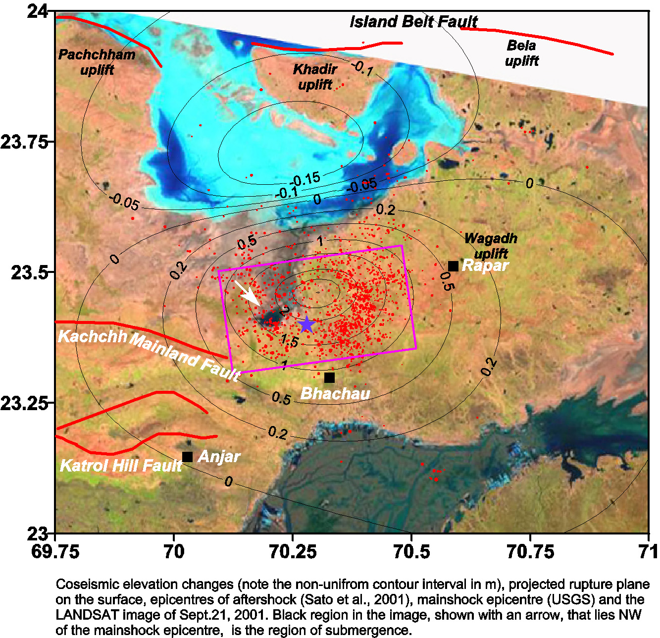
of Rann of Kuchchh on a south dipping reverse fault (Fig.1). The rupture of the
earthquake did not extend up to the surface, as subsequent field investigations
did not provide any evidence of coseismic rupture and land deformation due to
primary faulting. Though the earthquake occurred in the modern era of
seismology, it generated almost no near-field data as the region is poorly
instrumented. Thus our knowledge about the rupture process of this earthquake
and process of earthquake occurrence in the region is largely lacking. We
analysed the satellite imagery, namely, LANDSAT, ASTER, SPOT, and IRS, taken
before and after the earthquake to constrain some of the rupture parameters.
From the satellite imagery before and after this earthquake, it appears that about 15 km WNW of the reported USGS epicenter, ponding in an area of about 50 km^2 occurred in the ensuing monsoon period whereas prior to 2001, namely in 1999 and 2000, the submergence occurred further north of this region. The observed changes in the distribution of submerged areas during the monsoon are consistent with a zone of uplift near 23.5+-0.05 degree latitude and the predicted coseismic elevation changes. The dislocation model predicts subsidence in the north which coincides with the low lying salt flat region between the Pachham and Khadir islands (Fig.1). This apparent correlation between the earthquake induced subsidence and the low lying area suggests that similar large earthquakes in this region occurred in the past. We suggest that the distance between the inferred uplift and the subsidence puts and additional constraints on the location and depth of the rupture (Fig.1). Thus a rupture model with slip on a 40kmx25km rupture, extending from a depth of about 37 km to 10 km is consistent with the models suggested previously from teleseismic waveform inversions and the aftershock distribution. It appears that this uplift also shifted the southern limit of the adjacent salt region to the north. Our efforts to form interferograms using InSAR interferograms proved largely unsuccessful. The periodic submergence of the region during monsoon season led to incoherent interferograms for times spanning the earthquake. A related effort in our group uses finite element modeling to explore possible sources of the driving stress that gave rise to this large, interplate earthquake. We evaluate the effects of the weight of sediments in the alluvial fan of the Indus river on the regional tectonic stresses.
|
| Tools | Satellite Imaging, Elastic Boundary-Element Modeling, InSAR, Finite ELement Modeling |
| Geographic Location | Rann of Kuchchh, western India |
| Project Duration | Ongoing |
| Group Members Involved | Vineet Gahalaut, David Schmidt, Wren Montgomery, Roland Bürgmann |
| More Information | < InSAR results > |