The Morgan Hill Earthquake of 1984

|
|
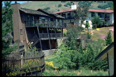
Two houses in Morgan Hill. A landslide caused the house in the foreground to move to the left. Notice the crack in the wall, next to the chimney.
Image: Karl Steinbrugge
Courtesy of the National Information Service for Earthquake Engineering, EERC, University of California, Berkeley
|
The Morgan Hill earthquake, also called the Halls Valley earthquake,
occurred on 24 April 1984 along the Calaveras fault 18 km east of San Jose
and 22 km north of Morgan Hill. It had a magnitude of ML=6.2 and a focal
depth of 8 km. The earthquake was felt in California and Nevada over an
area of 120,000 km2 and caused damage estimated to be worth $7.5 million.
After the earthquake, many cracks were found in the ground, but no
unequivocal evidence of surface faulting was found. The aftershocks define
an area that extends approximately 30 km southeast of the epicenter along
the Calaveras fault. This is the section of the fault that has generally
regarded as having ruptured at depth during the earthquake.
The USGS community intensity map shows the location of
the epicenter, and the intensity of shaking based on survey responses
collected after the event. You can mouse over each zip code to see the
total number of responses. If you happen to have lived in the Bay Area in
1984, and you remember this earthquake, you
can still fill out a report.
The following table lists reports of the effects of the Morgan Hill earthquake in different places. Complete the table by assigning MMI intensities for all of the locations. Intensity is usually given in Roman numerals, but please don't use Roman numerals for this exercise, the program that will grade your work isn't capable of handling them.
You can give intermediate values (e.g., 4.5) if you feel it is appropriate. You may wish to print a copy of this page and write down your answers, so that you can quickly re-enter them if your work is interrupted.

