
InSAR at UC Berkeley
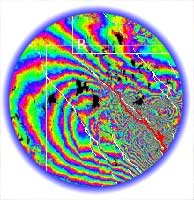 Interferometric Synthetic Aperture Radar (InSAR) is an increasingly
popular tool for observing a variety of earth processes, including studies
in geomorphology, atmospheric science, glaciology, and crustal deformation.
A list of paper references demonstrating the breadth of disciplines utilizing
radar data can be found at the SAR
reference page maintained by the JPL
Imaging Radar Home Page. The technique uses changes in
phase between repeated radar images to infer changes in travel time of
the electromagnetic signal. These fluctuations can be attributed
to changes in topography due to deformation or changes in the travel time
due to variations in the index of refraction through the atmosphere.
An explanation
of imaging radar and an introduction
to SAR interferometry can be found at the JPL
imaging Radar Home Page.
Interferometric Synthetic Aperture Radar (InSAR) is an increasingly
popular tool for observing a variety of earth processes, including studies
in geomorphology, atmospheric science, glaciology, and crustal deformation.
A list of paper references demonstrating the breadth of disciplines utilizing
radar data can be found at the SAR
reference page maintained by the JPL
Imaging Radar Home Page. The technique uses changes in
phase between repeated radar images to infer changes in travel time of
the electromagnetic signal. These fluctuations can be attributed
to changes in topography due to deformation or changes in the travel time
due to variations in the index of refraction through the atmosphere.
An explanation
of imaging radar and an introduction
to SAR interferometry can be found at the JPL
imaging Radar Home Page.
Our group uses InSAR to monitor crustal deformation due to elastic strain buildup along seismogenic faults and basin subsidence resulting from aquifer withdrawal. A more detailed overview of our projects can be found on our research page. Below are links to other groups utilizing InSAR in their research.
- Radar Interferometry Group at Stanford University
- SAR Research group at UCSD-IGPP, Scripps Institution of Oceanography
- Imaging Radar Group at JPL