
Active Research
Our research projects span a wide geographic area and address a range of topics within the field of active tectonics. Below is a list of some of our active and recent projects subdivided into catagories based on the large-scale problem each addresses. Follow the links for further information, resources, and data for each project.
Earthquake Cycle Deformation (top)
Geodetic imaging of the interplay between creep, locking, earthquakes and land subsidence along the Chaman plate boundary
The Chaman transform fault system of Pakistan and Afghanistan is one of the most prominent continental strike-slip plate boundary zones in the world. It stretches >1200 km from the Arabian Ocean in southern Pakistan to the Hindu Kush mountains in Afghanistan, forming the western boundary of the India plate with the Eurasian plate. The greater Chaman fault system has hosted a series of large and destructive earthquakes, including the 1892 M6.6 Chaman, the 1909 M7.1 Kachhi, the 1931 M7.3 Mach, the 1935 M7.7 Quetta, the 2013 M7.7 Balochistan, and more recently, the 2022 M6.0 Afghanistan-Pakistan earthquakes. Despite the history of large and destructive earthquakes, modern geodetic measurements across the Chaman transform boundary are limited, due to the harsh landscape and generally difficult access. To date, we do not know the individual slip rates and locking depths of faults within the Chaman fault system, nor do we know where interseismic strain is accommodated beyond the Chaman and Ghazaband faults.
In addition to the tectonic loading, hydrological processes also generate and impact deformation patterns throughout the Chaman fault system. In particular, the rapid exploitation of groundwater has caused widespread land subsidence across much of the Indus basin and northern Balochistan. The groundwater extraction and resulting subsidence not only cause damage to buildings and infrastructure and permanent compaction of fine sediment layers, resulting in a significant decline in the groundwater level and the storage potential of the aquifer. Measuring and modeling the rates and impacts of surface deformation in agricultural regions and densely populated cities in Pakistan are essential to reducing the damage of local buildings and infrastructure due to land subsidence associated with groundwater extraction and to help the local authorities better manage the groundwater usage.
The goals of this project are to quantify the spatial and temporal distribution of surface deformation along Chaman transform fault system in Pakistan and Afghanistan using satellite geodesy, including InSAR, GNSS, and creepmeter measurements; and explore the mechanical interactions between fault creep, interseismic loading, seismicity, and ground deformation associated with groundwater extraction along the Chaman plate boundary.
Interseismic and creep: Spatiotemporal variations of surface deformation, shallow creep rate, and slip partitioning between the San Andreas and southern Calaveras Fault
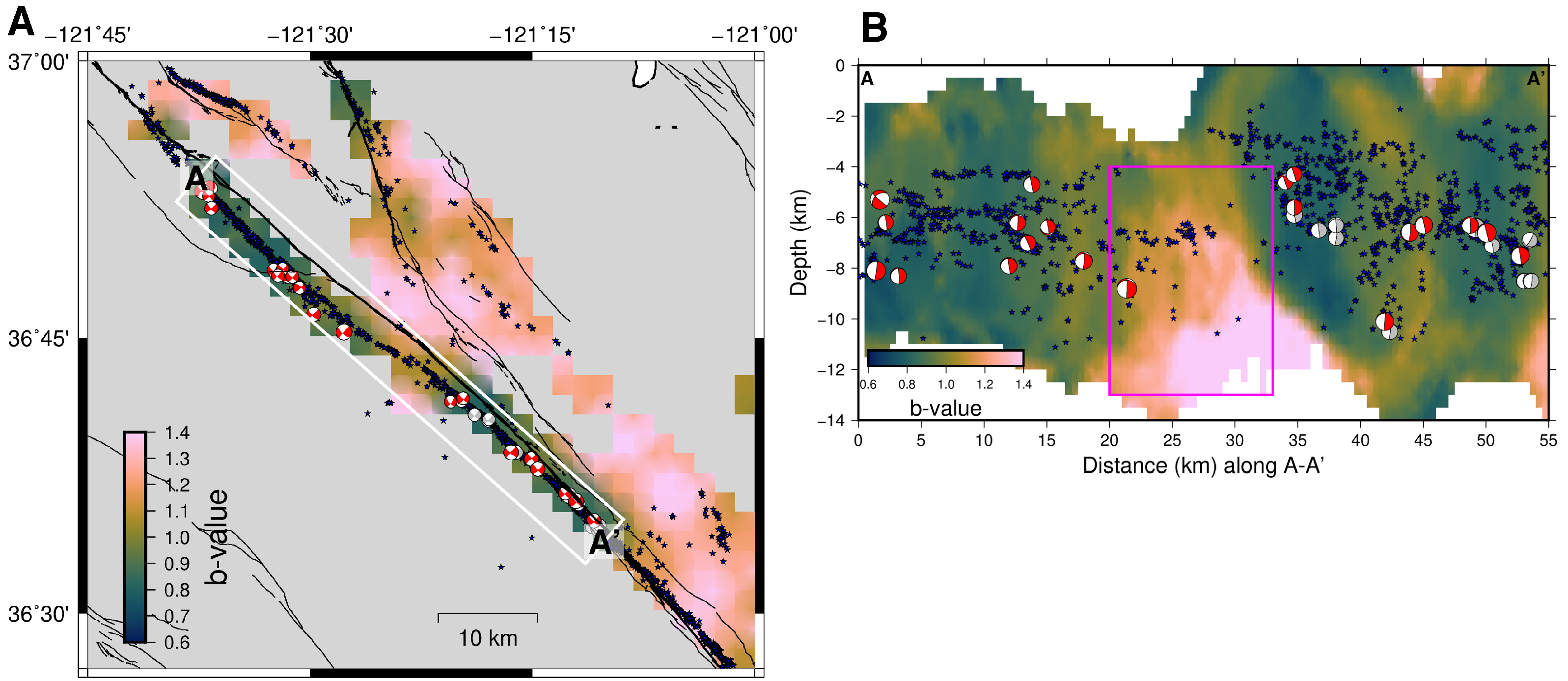
The Calaveras Fault (CF) branches from the San Andreas Fault (SAF) near San Benito, extending sub-parallel to the SAF for about 50 km with only 2-6 km separation and diverging northeastward. Both the SAF and CF are partially coupled, exhibit spatially variable aseismic creep and have hosted moderate to large earthquakes in recent decades. Understanding how slip partitions among the main fault strands of the SAF system and establishing their degree of coupling is crucial for seismic hazard evaluation. We perform a timeseries analysis using more than 5 years of Sentinel-1 data covering the Bay Area (May 2015-October 2020), specifically targeting the spatiotemporal variations of creep rates around the SAF-CF junction. We derive the surface creep rates from cross-fault InSAR timeseries differences along the SAF and CF including adjacent Sargent and Quien Sabe Faults. We show that the variable creep rates (0-20 mm/yr) at the SAF-CF junction are to first order controlled by the angle between the fault strike and the background stress orientation. We further examine the spatiotemporal variation of creep rates along the SAF and CF and find a multi-annual coupling increase during 2016-2018 the subparallel sections of both faults, with the CF coupling change lagging behind the SAF by 3 to 6 months. Similar temporal variations are also observed in both b-values inferred from declustered seismicity and aseismic slip rates inferred from characteristic repeating earthquakes. The high correlation of b-value and slip-rate changes may indicate that the SAF is extremely sensitive to small stress perturbations.
Probing fault frictional properties during afterslip up- and downdip of the 2017 Mw 7.3 Sarpol-e Zahab earthquake with space geodesy
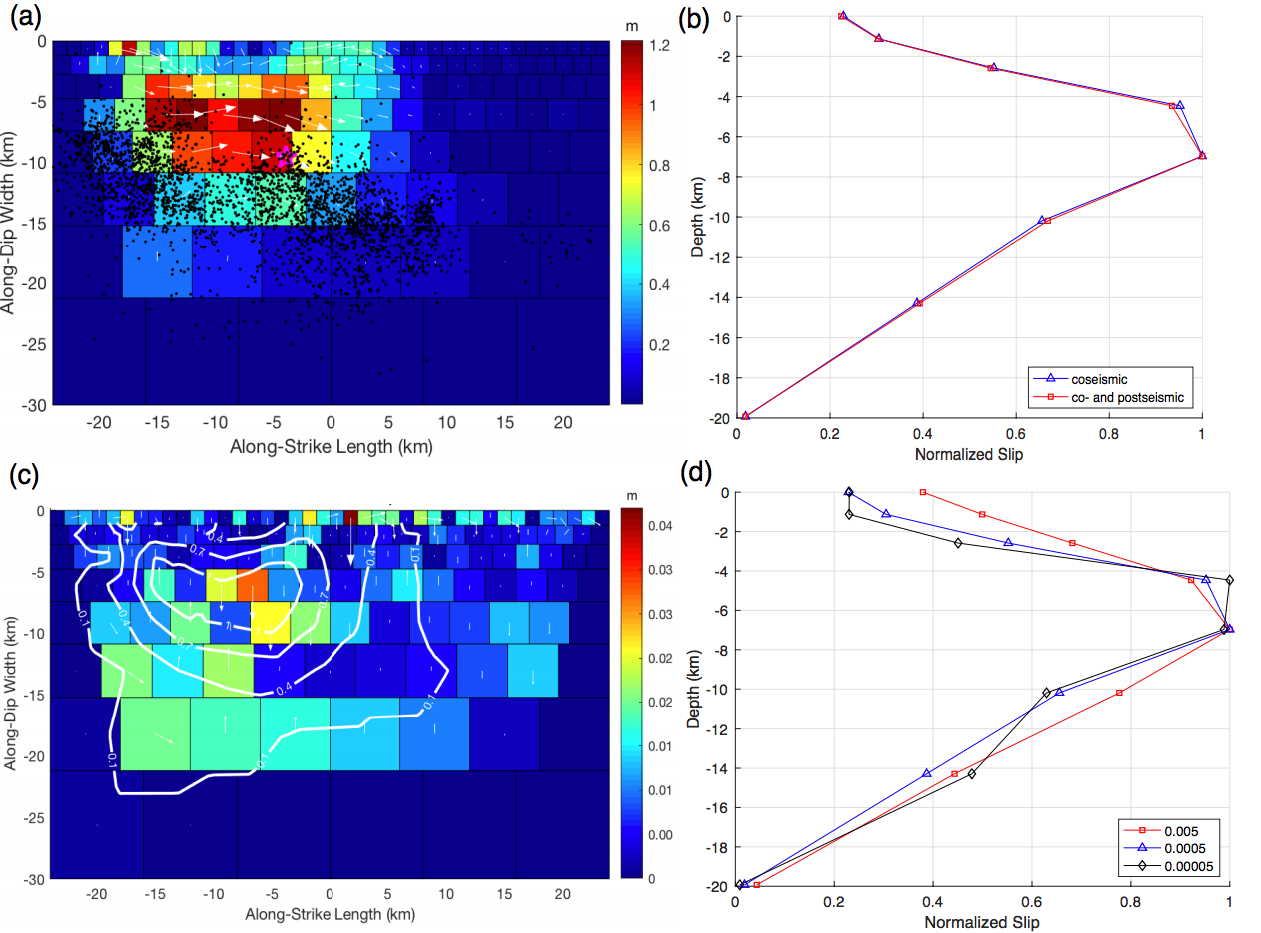
We use Interferometric Synthetic Aperture Radar (InSAR) data collected by the Sentinel-1 mission to study the co- and postseismic deformation due to the 2017 Mw 7.3 Sarpol-e Zahab earthquake that occurred near the Iran-Iraq border in Northwest Zagros. We find that most of the coseismic moment release is between 15 and 21 km depth, well beneath the boundary between the sedimentary cover and underlying basement. Data from four satellite tracks reveal robust postseismic deformation during ~ 12 months after the mainshock (from November 2017 to December 2018). Kinematic inversions show that the observed postseismic InSAR LOS displacements are well explained by oblique (thrust + dextral) afterslip both updip and downdip of the coseismic peak slip area. The dip angle of the shallow afterslip fault plane is found to be significantly smaller than that of the coseismic rupture, corresponding to a shallowly dipping detachment located near the base of the sediments or within the basement, depending on the thickness of the sedimentary cover, which is not well constrained over the epicentral area. Aftershocks during the same time period exhibit a similar temporal evolution as the InSAR time series, with most of aftershocks being located within and around the area of maximum surface deformation. The postseismic deformation data are consistent with stress-driven afterslip models, assuming that the afterslip evolution is governed by rate-strengthening friction. The inferred frictional properties updip and downdip of the coseismic rupture are significantly different, which likely reflect differences in fault zone material at different depths along the Zagros.
Co- and postseismic deformation due to 2019 Ridgecrest Earthquake Sequence
The 2019 Ridgecrest earthquake sequence culminated in the largest seismic event in California since the 1999 Mw 7.1 Hector Mine earthquake. Here, we combine geodetic and seismic data to study the rupture process of both the 4 July Mw 6.4 foreshock and the 6 July Mw 7.1 mainshock. The results show that the Mw 6.4 foreshock rupture started on a northwest-striking right-lateral fault, and then continued on a southwest-striking fault with mainly left-lateral slip. Although most moment release during the Mw 6.4 fore- shock was along the southwest-striking fault, slip on the northwest-striking fault seems to have played a more important role in triggering the Mw 7.1 mainshock that happened ∼34 hr later. Rupture of the Mw 7.1 mainshock was characterized by dominantly right-lateral slip on a series of overall northwest-striking fault strands, including the one that had already been activated during the nucleation of the Mw 6.4 foreshock. The maximum slip of the 2019 Ridgecrest earthquake was ∼ 5 m, located at a depth range of 3-8 km near the Mw 7.1 epicenter, corresponding to a shallow slip deficit of ∼20%-30%. Both the fore- shock and mainshock had a relatively low-rupture velocity of ∼2 km/s, which is possibly related to the geometric complexity and immaturity of the eastern California shear zone faults. The 2019 Ridgecrest earthquake produced significant stress perturbations on nearby fault networks, especially along the Garlock fault segment immediately southwest of the 2019 Ridgecrest rupture, in which the coulomb stress increase was up to ∼ 0.5 MPa. Despite the good coverage of both geodetic and seismic observations, published coseismic slip models of the 2019 Ridgecrest earthquake sequence show large variations, which highlight the uncertainty of routinely performed earthquake rupture inversions and their interpretation for underlying rupture processes.
Interplay of seismic and aseismic slip on the San Andreas fault near San Juan Bautista, central California
The central creeping section of the San Andreas fault (SAF) from Parkfield in the south to San Juan Bautista (SJB) in the north is creeping aseismically and separates the locked portions of the fault that rupture in great earthquakes. The transition between creeping and locked fault sections is a preferential zone of earthquake nucleation, where frictional heterogeneity leads to a complicated relationship of seismic and aseismic slip. The location in a locking transition, numerous moderate-sized local earthquakes, a historic record of aseismic slip transients, and dense instrumentation near SJB make it an excellent natural laboratory to study the interplay of seismic and aseismic slip. We are combining seismic and geodetic observations from 1993-2021 to study aseismic slip transients and their relationship to moderate-sized local earthquakes and address a number of fundamental questions: How often does aseismic slip lead to earthquakes, how often do these earthquakes lead to aseismic slip? What is the relationship between shallow and deep slip? What are the scales and patterns of spatiotemporal changes in creep rate along this locking transition? What is the largest earthquake we can expect in the region? We are searching for near-repeating and repeating earthquakes related to 20 moderate-sized local earthquakes that may be indicative of triggered aseismic slip transients. We further look at detailed spatial changes in earthquake statistics and an anomalous region potentially indicative of increased locking. We are also exploring spatiotemporal changes in frequency content of earthquakes that may illuminate variable frictional fault properties. We will combine these seismic observations with geodetic (i.e., cGPS, InSAR, creepmeters, borehole strainmeters) data to confirm apparent changes in creep rates and model aseismic slip transients. Further, we are installing new creepmeter pairs to capture propagation velocity of creep events along the SAF to better evaluate changes in creep rates along the fault. Studying the interplay of seismic and aseismic slip in this well-instrumented region may provide insights into other tectonic environments, particularly the offshore portion of subduction zones, where direct observations are limited.
Episodic tremor and slip episodes on the south-central Alaska megathrust
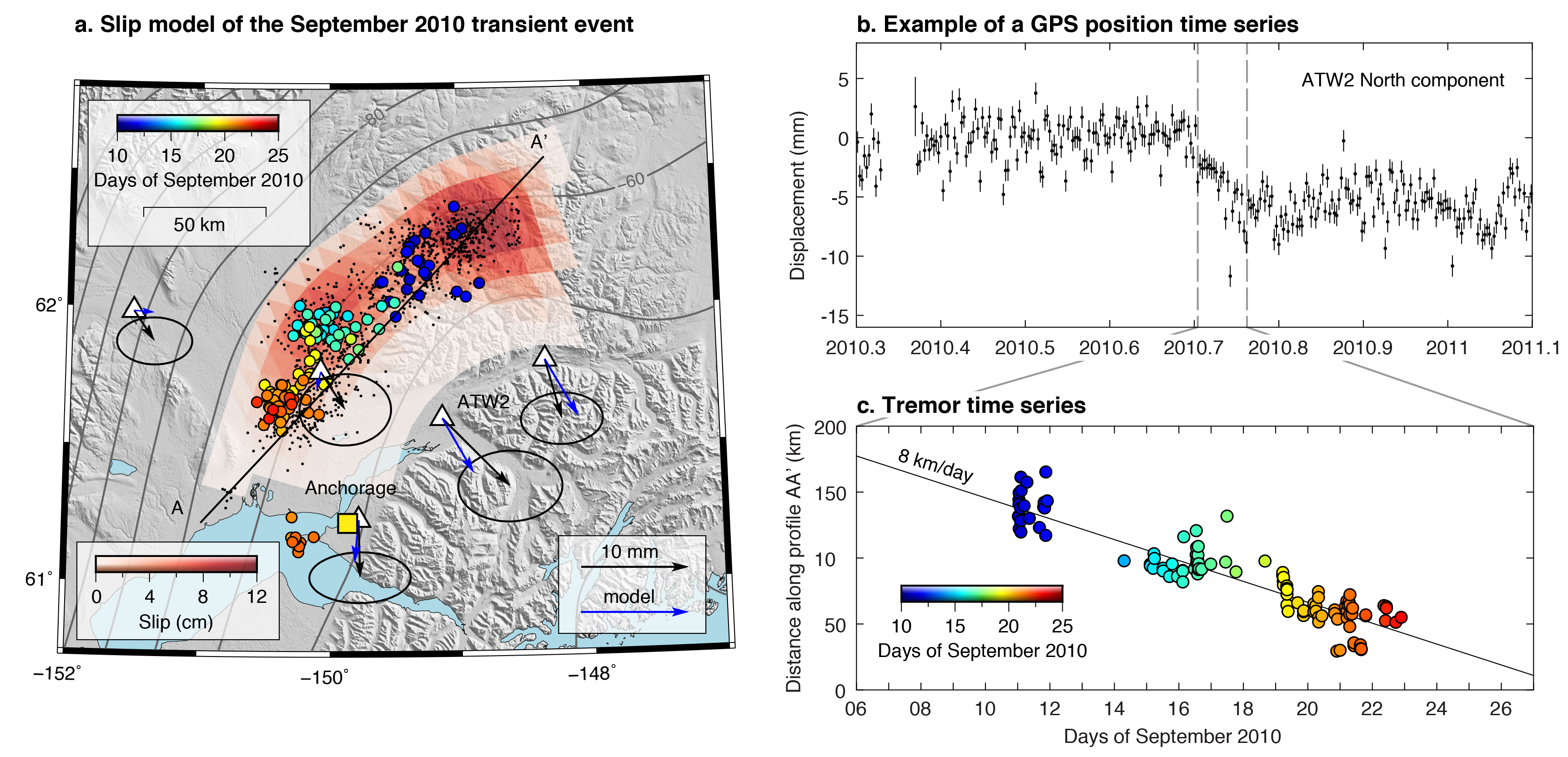
We jointly investigate aseismic slip transients and tremor activity in south central Alaska. Near the eastern downdip edge of the Mw 9.2 1964 Prince Williams earthquake rupture, kinematic modeling of the Mw=7.6 2009–2013 slow slip event suggests cumulative transient slip of up to 55 cm. During this 5‐year transient event, tectonic tremors were co‐located with the inferred aseismic slip zone and occurred in weeks‐long bursts of events. A short‐term transient deformation event is observed in the GPS time series spanning a tremor burst in September 2010. The time‐dependent slip modeling of this Mw=6.9 subevent shows that it migrated along strike with tremor at speeds of ∼8 km/day and with slip rates of ∼3 mm/day. It released 9% of the 5‐year transient event total moment in 1.4% of its duration. The decomposition of GPS time series relative to tremor times during the whole 5‐year transient event shows that GPS site velocities were on average three to six times higher during tremor bursts than in between, suggesting that slip pulses are generally associated with tremor bursts. This inference is strengthened by the decomposition of the GPS time series after the 5‐years‐long deformation event, during which the plate interface is being loaded in between the short‐duration events and slips at times of tremor bursts. The 5‐years‐long transient deformation event could either represent a cluster of short‐term events or be the sum of short‐term ETS events and a smooth long‐term slip event located updip.
Slow slip events in the roots of the San Andreas fault
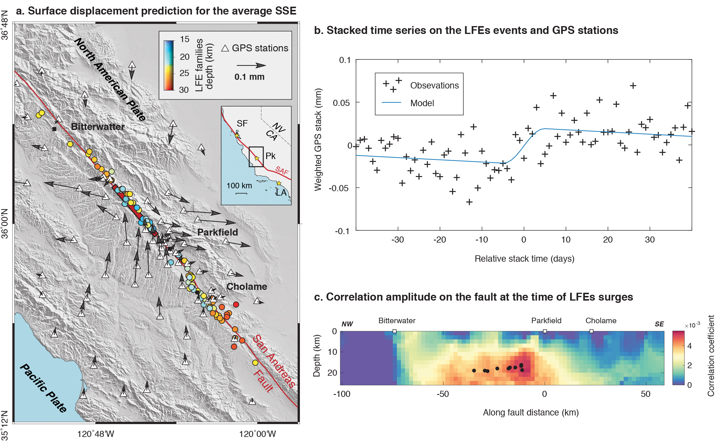
Episodic tremor and accompanying slow slip is observed at the down-dip edge of some subduction seismogenic zones. While tremors present the seismic signature of this phenomena, the majority of accumulated stress is aseismically released and thus the associated fault slip can only be quantified by geodetic observations. On continental strike-slip faults, tremors have been observed in the roots of the Parkfield segment of the San Andreas fault. However, associated transient aseismic slip has never been detected. By using the timing of transient tremor activity and taking advantage of the dense Parkfield-area global positioning system (GPS) network with more than a decade of continuously recorded position time series, we are able to detect and characterize the moment of average deep slow slip events (SSEs) on the Parkfield segment. The detection is made using a geodetic matched filter approach in which post-processed GPS time-series stacked over 20 transient events are correlated with synthetic dislocation fault slip models. SSEs with an average moment equivalent to Mw 4.90 ± 0.08 at 16 km depth are releasing ∼ 25% of the loading rate during 5.5% of the interseismic time. The detection of these transient slow slip events located at the northern down-dip edge of the Parkfield locked asperity, at the transition with the creeping section of the San Andreas Fault, provides new constraints on the understanding of the Parkfield seismic cycle.
Interseismic and creep: Partial coupling and earthquake potential along the Xianshuihe Fault, China
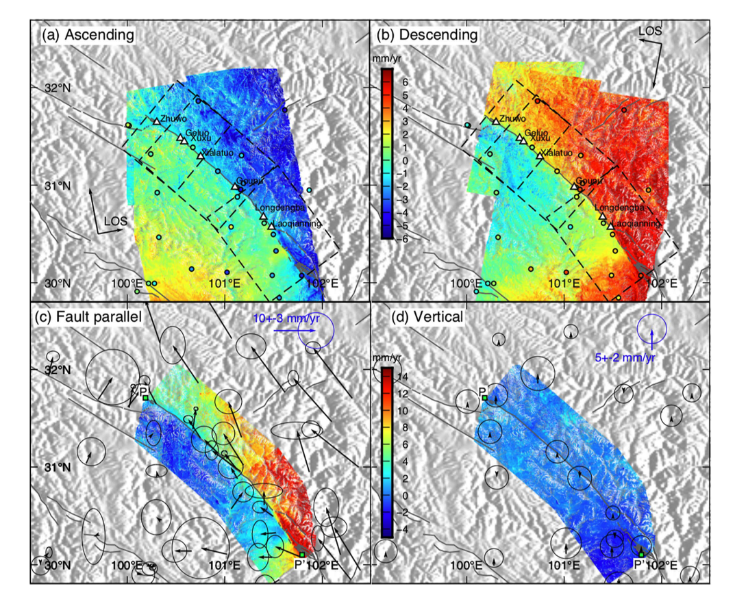
The left-lateral Xianshuihe Fault is located at the eastern boundary of the Tibetan Plateau and is one of the most active faults in China. It is associated with substantial seismic potential, with more than 20 Mw>6 earthquakes since 1700. The fault has been documented to be creeping at the surface for decades; however, the spatial and temporal distributions of shallow creep along the fault are not well resolved. In this study, we obtain high-resolution interseismic velocity maps along the 350-km-long central Xianshuihe Fault and Interferometric Synthetic Aperture Radar (InSAR) time series along the Kangding segment using ascending and descending Sentinel-1 data. The InSAR data reveal multiple creeping sections and the estimated surface creep rates show high along-strike variability. A coupling model characterizes the distribution of creep with depth. The seismic potential of apparent rupture asperities along the Xianshuihe Fault is further refined by considering fault-crossing baseline data and the distribution of historical ruptures and microseismicity. Moreover, a stress-driven afterslip model of the observed accelerated creep around the Mw 5.9 2014 Kangding rupture indicates substantial shallow afterslip, which provides further constraints on the distribution of locked and creeping patches along this section of the Xianshuihe Fault.
Interseismic and creep: Interseismic Coupling Changes in Southern Cascadia
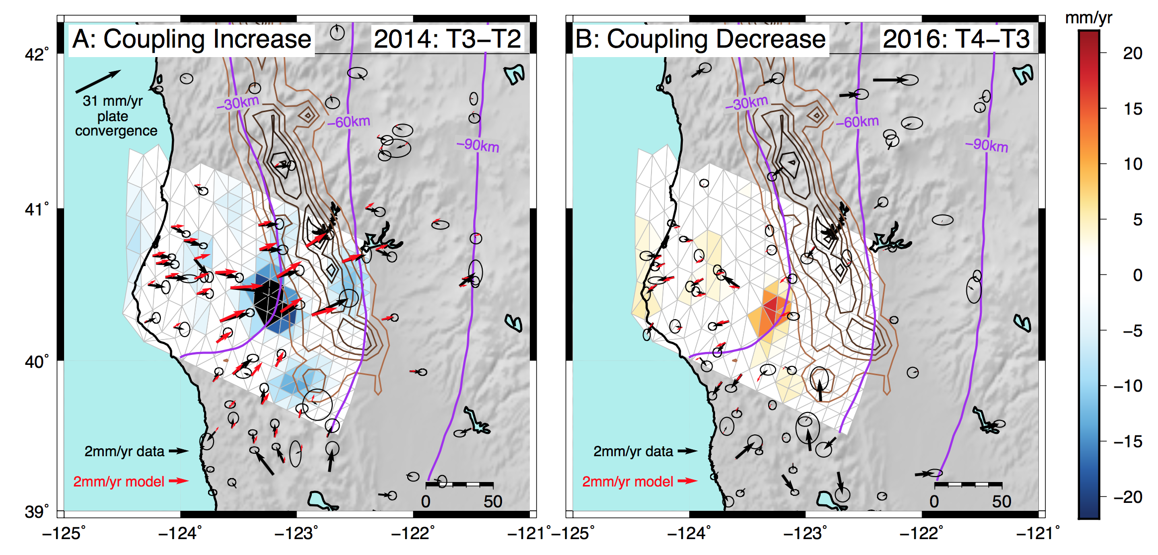
Plate convergence across the Cascadia Subduction Zone is the dominant source of tectonic strain accumulation in Humboldt County, California. However, in a small region near the Mendocino Triple Junction, the rate of strain accumulation appears to undergo systematic variations with time over the past decade. After correcting several dozen interseismic GNSS time series for coseismic offsets, annual/interannual hydrological loading, and episodic tremor and slip (ETS) events, we find coherent GNSS velocity changes at times that correspond to moderate-magnitude offshore earthquakes. These velocity changes are not well-modeled by afterslip, interannual hydrological loading, or static stress interactions. Instead, we invert the observations for coupling changes on the Cascadia megathrust and find a concentrated region of coupling change at approximately 25 km depth. The implications of our results are that the megathrust region just up-dip of the ETS zone, whose coupling state is unknown, undergoes longer-term, non-ETS coupling changes during the interseismic phase of the seismic cycle. A further implication is that dynamic shaking may be capable of changing the coupling state on this transitional portion of the megathrust, an effect that may be observed in other subduction systems but is not yet considered in seismic hazard assessments.
Repeating Earthquakes at the Mendocino Triple Junction
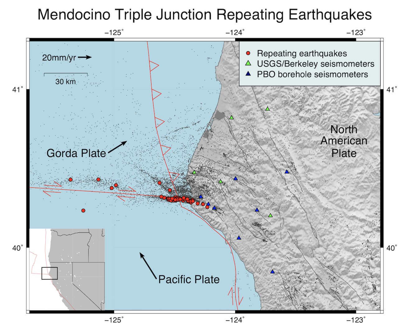
The Mendocino Triple Junction (MTJ) is a seismically active region at the transition between the San Andreas Fault system, the Mendocino Transform Fault, and the Cascadia Subduction Zone in Northern California. The triple junction itself is located offshore, making it difficult to study using traditional land-based methods. In this project, we document the occurrence of characteristically repeating earthquakes (CREs) near the MTJ and interpret them as indicators of aseismic creep. The CRE data implies a creep rate of ~3 cm/yr on the downgoing extension of the Mendocino Transform Fault, consistent with other estimates of low coupling on oceanic transform faults. We also find repeating earthquakes on the southern margin of the North American accretionary wedge. This project demonstrates the ability of CREs to monitor aseismic creep and its time-dependent features in a plate boundary region outside the coverage of current geodetic networks.
Interseismic and creep: Interseismic deformation and refined earthquake potential on the Hayward-Calaveras Fault system
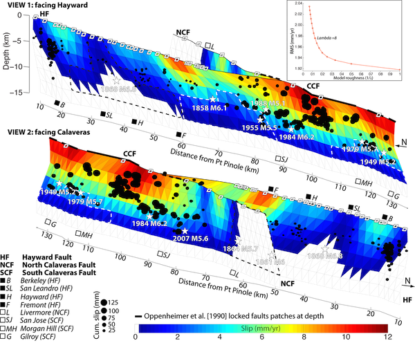
Evaluation of interseismic strain accumulation and creep traditionally relies on GPS, alignment arrays, and creepmeters, providing precise, but spatially sparse measurements. Here, we use InSAR to resolve interseismic deformation associated with the Hayward and Calaveras Faults, in the East San Francisco Bay Area, with a high spatial resolution. We keep InSAR independent from GPS and alignment arrays data and show that a large SAR dataset enables characterization of short and long-wavelength deformation signal as small as 2 mm/yr without the need of aligning the velocity field to GPS-based model of strain accumulation. By implementing an interferogram selection directly based on the spatial coherence, our modified time series approach enables deformation mapping in vegetated areas and leads to refined estimates of along fault-creep rates. Creep varies from 0 on north Calaveras to ~12 mm/yr on central Calaveras, the Calaveras Fault reaching its maximum creep rate south of the surface junction with the Hayward Fault. We estimate long-term slip rate on these faults by inverting the long-wavelength deformation, and shallow slip due to creep using the short-wavelength deformation. The slip distribution reveals locations of locked and slow creeping patches with capabilities of a M6.4 near San Leandro, a M6.5 near Livermore, a M6.3 south of Fremont, and a M6.1 near Morgan Hill. By considering the potential for cascading multi-segment ruptures the Hayward Fault could produce a M6.9, the north Calaveras Fault a M6.7, the central Calaveras Fault a M6.9, and a joined rupture involving the Calaveras Fault and the Hayward Fault could produce a M7.1.
Postseismic: Evidence of fault immaturity from shallow slip deficit and lack of postseismic deformation of the 2017 Mw6.5 Jiuzhaigou earthquake
The Mw 6.5 Jiuzhaigou earthquake occurred on 8 August 2017 36 km WSW of Yongle, Sichuan, China. We use both ascending and descending Sentinel-1 InSAR and coseismic offsets of four GPS sites to obtain the coseismic surface deformation field and invert for the fault geometry and slip distribution. Most slip of the left-lateral strike-slip earthquake occurred in the 3-10 km depth interval with a maximum slip of about 1 m and a large shallow slip deficit (SSD). An 8-month InSAR time series analysis documents a lack of resolvable postseismic deformation. Inversions for the distribution of co- and postseismic slip demonstrate the existence of a SSD and lack of shallow afterslip. We argue that the observations of a pronounced SSD and no early afterslip of the Jiuzhaigou earthquake are indicative of an immature fault and that all incipient young strike-slip faults likely feature a SSD. We would expect complex rupture geometry with distributed coseismic failure in the uppermost part of the brittle crust during the fault zone development. As faults mature, they straighten out, develop a localized fault zone core, and the SSD diminishes.
Postseismic: Probing deep rheology across the eastern margin of the Tibetan plateau: Constraints from the 2008 Mw 7.9 Wenchuan earthquake
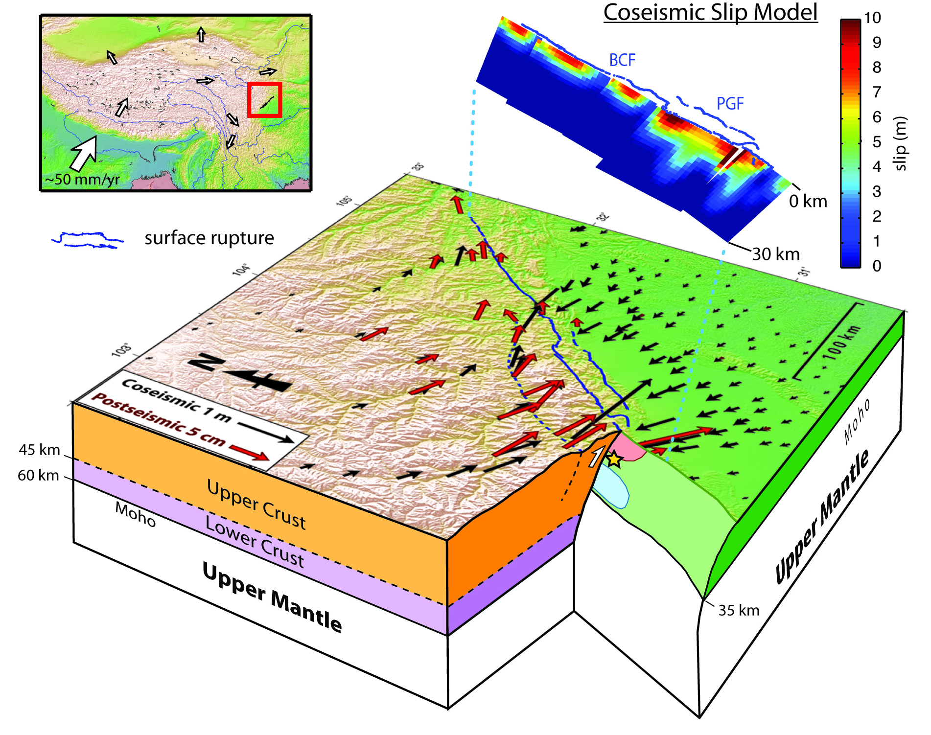
The fundamental geological structure and rheology of the Tibetan plateau have been debated for decades. Two major models have been proposed: (1) the deformation in Tibet is distributed, and associated with ductile flow in the mantle or lower crustal flow (LCF); (2) the Tibetan plateau was formed during interactions among rigid blocks with localization of deformation along major faults. On 12 May, 2008, a Mw 7.9 earthquake occurred on the Longmen Shan that separates the eastern Tibetan plateau and the Sichuan basin. The earthquake ruptured ~235 km of the Beichuan fault (BCF) and the entire Pengguan fault (PGF). Geodetic inversions show more than 5 slip asperities and ~16 m peak slip on SW BCF. All of the slip models show oblique thrusting along the SW BCF and a right-slip component gradually increases towards the NE end of the BCF. The postseismic displacement is a response to the redistribution of stresses induced by the earthquake and can be used to probe the deep rheologic properties underneath the surface (Wang et al., 2012). Here we incorporate two-year long geodetic measurements and numerical modeling to examine two end-member hypotheses to provide further evidence to the deep rheology in eastern Tibetan plateau.
Volcano Deformation (top)
Interseismic Quiescence and Triggered Slip of Active Normal Faults of Kīlauea Volcano's South Flank During 2001–2018
The mobile south flank of Kīlauea Volcano hosts two normal fault systems, the Koa'e fault system (KFS) and the Hilina fault system (HFS). In historical time, at least three M>6.5 earthquakes have occurred on the basal detachment of the Kīlauea Volcano's south flank, with the most recent being the 4 May 2018 M6.9 earthquake. Here we analyze kinematic Global Positioning System data collected from 2001 to 2017 and interferometric synthetic aperture radar data before, during, and after the 2018 M6.9 earthquake to determine the crustal motion across the HFS and KFS faults. Our results indicate that the HFS faults did not significantly slip during the interseismic period from 2007 to 2011. Despite its substantial magnitude, interferometric synthetic aperture radar (InSAR) data show that the 2018 M6.9 earthquake triggered subcentimeter level slip along sections of the previously mapped HFS branches. Up to 20 cm of offset occurred on what appears to be a newly formed (or previously unknown) fault near the eastern end of the HFS. During the 3 months following the M6.9 earthquake, up to ~30 cm of slip occurred along the KFS, which helps accommodate rapid large‐scale subsidence of Kīlauea's summit region as large volumes of summit reservoir magma fed the lower East Rift Zone eruption. The HFS appears to activate only in concert with large earthquakes on the basal detachment. The KFS, on the other hand, moves both seismically during small local earthquakes and aseismically in response to nearby earthquakes and caldera subsidence.
Non-tectonic Deformation (top)
Aquifer and seismicity in Salt Lake Valley, Utah
Aquifers and fault zones may interact through groundwater flow and stress redistribution, yet their spatiotemporal relationship remains enigmatic. Here we quantify changes in water storage and associated stress along the Wasatch Fault Zone in Salt Lake Valley. Ground deformation mapped by Sentinel-1 SAR imagery (2014-2019) reveals an elongated area with ~50-mm seasonal uplift corresponding to 0.03-0.06-km3 water storage cycles. Phase shifts across active faults in both water level and deformation suggest control by the low-permeability structures. The seasonal stress changes on the adjoining faults from poroelastic volume strain are two orders of magnitude larger than those from hydrological surface loading, but both are small compared to the annual increase of tectonic loading at seismogenic depths. Historic seismic events, limited in number, do not exhibit statistically significant annual periodicity and hydrological modulation of microseismicity or triggering of the recent M5.7 event is not evident.
Surface and subsurface dynamics of the Slumgullion landslide from ground, air and space
With its large area of ~1 km2 and perennial motions at ~10-20 mm/day, the Slumgullion landslide in Colorado, USA, represents an ideal natural laboratory to better understand landslide behavior. Here, we use hybrid remote sensing data and methods to recover the four-dimensional surface motions during 2011-2018. We refine the boundaries of an area of ~0.35 km2 below the crest of the prehistoric landslide. We construct a mechanical framework to quantify the rheology, subsurface channel geometry, mass flow rate, and spatiotemporally dependent pore-water pressure feedback through a joint analysis of displacement and hydrometeorological measurements from ground, air and space. Variations in recharge, mainly from snowmelt, drive multi-annual decelerations and accelerations, during which the head of the landslide is the most responsive. The power-law flow theory helps reconcile the mass movement with the subsurface geometry which is explicitly characterized by a novel description of the landslide thickness, the steepness between the lateral and bed shear surfaces, and the tilt of the basal bed.
Rheology of the debris slide
Landslide rheology governs the deformation and flow behavior of sliding masses. As rheology strongly varies as a function of the composition and environment of landslides, a wide range of viscosities have been suggested based on very limited experimental or observational constraints. Here we introduce a novel method to quantify the landslide rheology from remote sensing data. We focus on an ideal natural laboratory – the Slumgullion landslide, Colorado, which has moved at tens of millimeters per day for centuries. A joint analysis of UAVSAR InSAR-derived surface displacements and LiDAR DEM-derived landslide thickness at its toe allows us to invert for the intrinsic viscosity based on the Bingham plastic model. Detailed displacement measurements also elucidate local variations in magnitude and orientation. Our method presents the capability of remote sensing data to understand the rheology of quasi-static debris slides in general.
Mobility, thickness, and hydraulic diffusivity of the Monroe landslide, CA
Here we use L-band ALOS-1 and ALOS-2 InSAR observations, to characterize the geometry and the spatio-temporal deformation of the slow-moving, deep-seated Monroe landslide in northern California between 2007 and 2017. InSAR phase discontinuities show that the landslide is bounded by discrete strike-slip faults at the lateral margins, and segregated into distinct kinematic elements by normal and thrust faults. We find that the Monroe landslide has been moving consistently, with a maximum rate of about 0.7 m/yr in the narrowest longitudinal center of the transport zone. The thickest landslide mass is estimated to be in a zone located between subsiding and the uplifting kinematic elements at the lower transport zone. The timing and magnitude of the landslide displacement are modulated by the intensity and duration of precipitation, as well as the antecedent water content of the landslide mass. In addition, we use a one-dimensional pore-water pressure diffusion model to estimate the rainfall-modulated pore-water pressure changes and hydraulic diffusivity.
Hydrological Loading in South Asia, and Southeast Asia
The elastic response of the lithosphere to surface mass redistributions can be observed in many geodetic time series. This loading deformation produces especially large-amplitude signals in South and Southeast Asia due to the annual monsoon. In this project, in collaboration with the Earth Observatory of Singapore, we use GRACE temporal gravity products as an estimate of the long-wavelength surface water distribution in South and Southeast Asia, and we compare the predicted vertical deformation from GRACE with that observed with GNSS. We find that elastic loading inferred from the GRACE gravity model is able to explain the phase and much of the peak-to-peak amplitude of observed GNSS time series, especially in northeast India and central Myanmar. However, this approach does not capture all of the seasonal deformation in other regions such as central Bangladesh and southern Myanmar. We find that two independent hydrological models of surface water have poorer matches with the phase of the GNSS observations, a feature we attribute to water in the groundwater system. By using the GNSS data together with estimates of hydrological loading from independent observations and models, we may be able to more accurately determine crustal motions caused by tectonic processes in South and Southeast Asia, while also improving our ability to monitor the annual monsoon and resulting water storage changes in the region.
Predictability of hydraulic head changes and characterization of aquifer system properties from InSAR-derived ground deformation
We use InSAR time-series analysis of ERS, Envisat, and ALOS data to resolve 1992-2011 vertical ground deformation associated with hydrological processes in the Santa Clara Valley, California. We extract temporally variable deformation patterns embedded in the multi-decadal time series without a-priori constraints using T-mode Principal Component Analysis (TPCA). The longer-term deformation, which corresponds to poroelastic rebound of the aquifer system following recovery of hydraulic heads after the 1960s low stand, occurs mostly prior to 2000, leading to uplift one order of magnitude smaller than its preceding subsidence. Two patterns of seasonal deformation also exist, both sharply partitioned by the Silver Creek Fault (SCF), the fault being a barrier to across fluid flow. We show that by combining this seasonal deformation with hydraulic head data we can characterize basin-wide aquifer system properties and that after callibration, we can accurately estimate water level changes from the observed deformation without well measurements.
Tectonic Geomorphology (top)
Geomorphic Expression of Active Tectonics across the Indo-Burma Range
Our first objective is to investigate the tectonic geomorphology including streams and drainage-basin characteristics, in order to examine evidence of active faulting and the distribution of tectonic uplift and to assess whether the subduction is active along the IBR region. For this purpose, we will analyze digital topography data using a number of morphometric indices. Secondly, we aim to examine how streams and drainages evolve and adjust over time under the oblique subduction regime. This will help us better understand the underlying longer-term tectonics in this region. By integrating information about both short- and long-term tectonics from geodesy, seismology, and tectonic geomorphology, we intend to obtain a better understanding of the active tectonics in this complex plate boundary zone.
Stress Field in Subduction Zones (top)
Tectonic Stress Field in the Indo-Burma Range
The debate over whether the Indian slab is currently subducting beneath the Burma microplate is important because it directly relates to the potential for great subduction earthquakes (M8 or above) in the future. In this study, we aim to investigate the stress field in the Indo-Burman Range in order to (1) understand plate driving forces and subduction dynamics, and (2) ultimately contribute to earthquake hazard assessments.
Fault Structure, Geometry and Frictional Properties (top)
Tremor-tide correlations and near-lithostatic pore pressures on the deep San Andreas fault
New observations of tidal triggering of non-volcanic tremor near Parkfield, CA present a uniqueopportunity to better understand the nature of tremor and the conditions under which it occurs. Here we perform a full tidal analysis to determine the stress orientations and magnitudes that favor tremor generation on the lower-crustal San Andreas fault. Our results show that extremely small shear stress perturbations primarily influence tremor activity levels while much larger normal stress fluctuations and stressing rates have little to no influence. These findings are indicative of near-lithostatic pore pressures in the deep San Andreas fault zone and suggest that low effective normal stresses explain the response of non-volcanic tremor to tidal forcing.
Inactive Research
Earthquake Cycle Deformation (top)
Coseismic Deformation
Joint Seismic and Geodetic Analysis of the 2009 Padang, Sumatra Intraslab Earthquake
Coseismic and postseismic deformation data and models of the August 17, 1999 Izmit earthquake and the November 12, 1999 Duzce earthquake
Surface deformation of the 2001 Bhuj earthquake from satellite imagery and InSAR data
Postseismic Deformation
Twenty-five years of postseismic viscous relaxation following the Mw 6.9 Loma Prieta earthquake
Plate Tectonics (top)
Using GPS velocities and block modeling to test independent Okhotsk plate motion
Indian Plate Motion, Deformation, and Plate Boundary Interactions