Kathryn Materna
Seismic and Aseismic Slip in the Brawley Seismic Zone
The Brawley Seismic Zone (BSZ), at the southern end of the San Andreas Fault system, hosts frequent seismic swarms including a 2012 swarm that produced two M5 earthquakes. Aseismic slip is known to accompany some of the seismic swarms in the BSZ. In this project, we consider a large collection of geodetic and seismic data to constrain the deformation contributions of seismic and aseismic slip in the last decade at the North Brawley Geothermal Field. We include GNSS data, leveling, UAVSAR, TerraSAR-X, and Sentinel-1 in our analysis. The decade-long time series displays evidence for aseismic slip in some intervals and deformation inconsistent with fault slip in other intervals, allowing us to probe the conditions under which slip occurs in the BSZ.
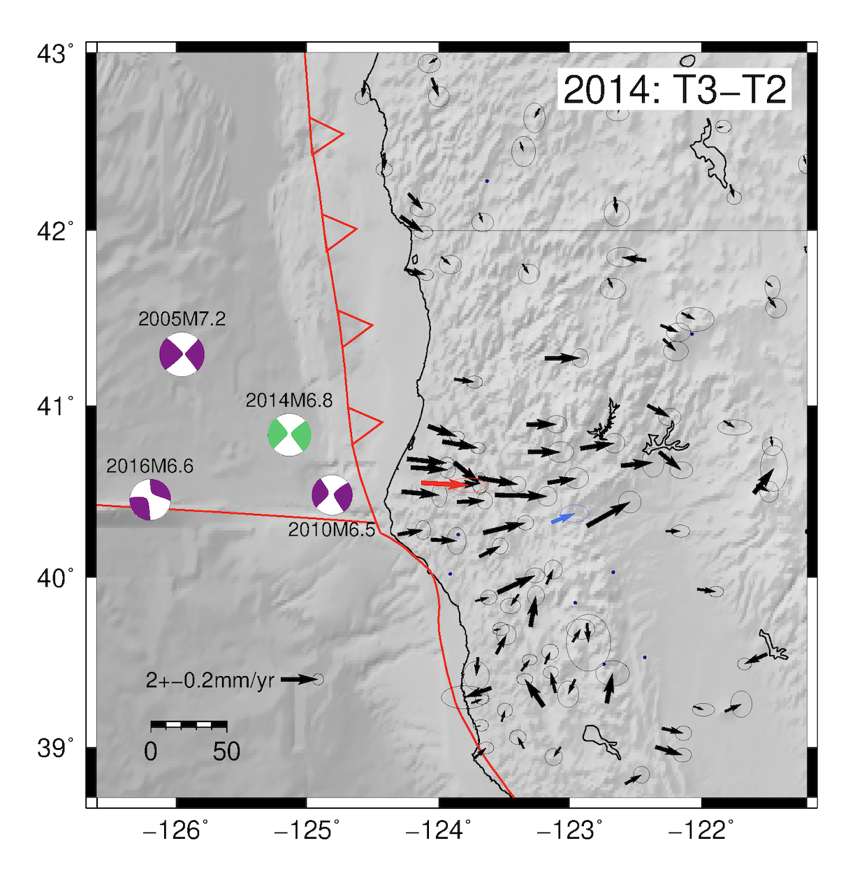
GNSS Velocity Changes at the Mendocino Triple Junction
In Southern Cascadia, precise GNSS measurements spanning about 15 years reveal steady deformation due to locking on the Cascadia megathrust punctuated by transient deformation from large earthquakes and episodic tremor and slip events. However, near the Mendocino Triple Junction, time-variable GNSS deformation suggests an additional process is active. After correcting for earthquakes and seasonal loading, we find that several dozen GNSS time series show spatially coherent east-west velocity changes of ~2 mm/yr, and that these changes coincide in time with regional M>6.5 earthquakes. After examining a range of other hypotheses, we consider dynamically triggered changes in megathrust coupling most likely to explain the data. This finding suggests that plate interface coupling may be variable with time during the interseismic period, which has implications for megathrust coupling models.
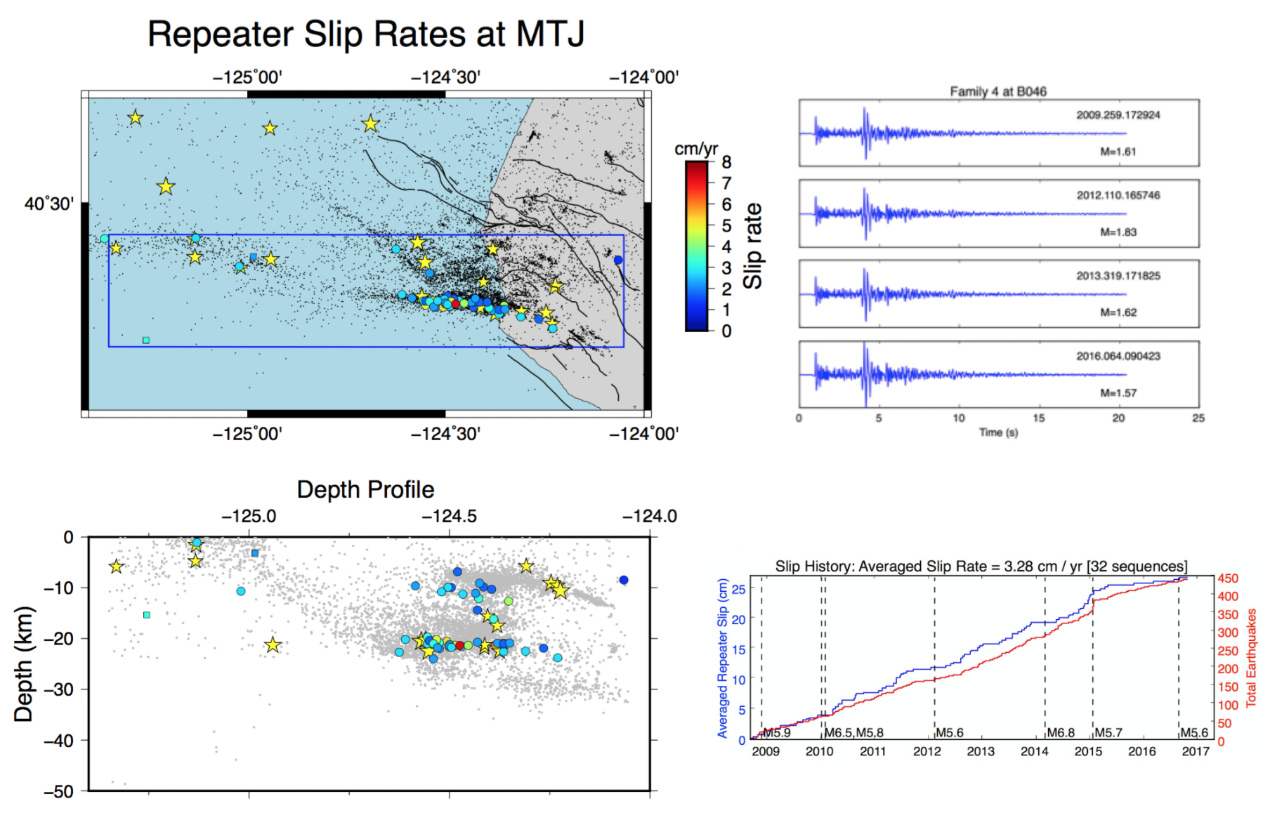
Repeating Earthquakes at the Mendocino Triple Junction
The Mendocino Triple Junction (MTJ) is one of the most seismically active regions of California, and provides a unique opportunity to study active oceanic transform faults close to land. In this project, we study characteristically repeating earthquakes on the Mendocino Transform Fault near the MTJ. We use these sequences of repeating earthquakes to determine fault creep rates and a time series of slip. We find that in a few places, up to 50% of the slip budget is accommodated aseismically through creep. This result can be used to create more realistic models of interseismic strain accumulation, earthquake interactions, and stress loading in the MTJ.
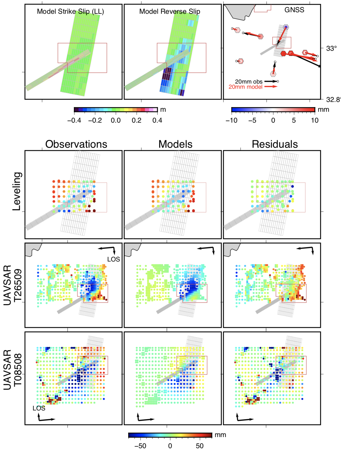
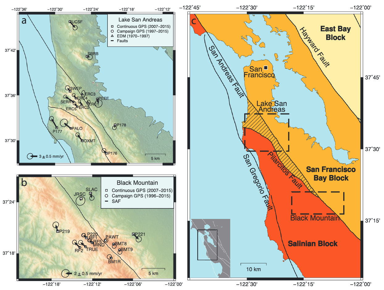
Compliant Fault Zones in the Bay Area
Many mature faults are characterized by damage zones that can extend hundreds of meters to several kilometers from the fault trace. These damage zones can impact the interseismic and co-seismic behavior of faults. On the San Andreas Fault, a major source of seismic hazard in the San Francisco Bay Area, we use dense networks of survey-mode and continuous GPS observations to place constraints on the mechanical properties of the fault zone. In particular, we investigate the contribution of a damage-zone structure called a compliant fault zone (CFZ) to the interseismic deformation field.
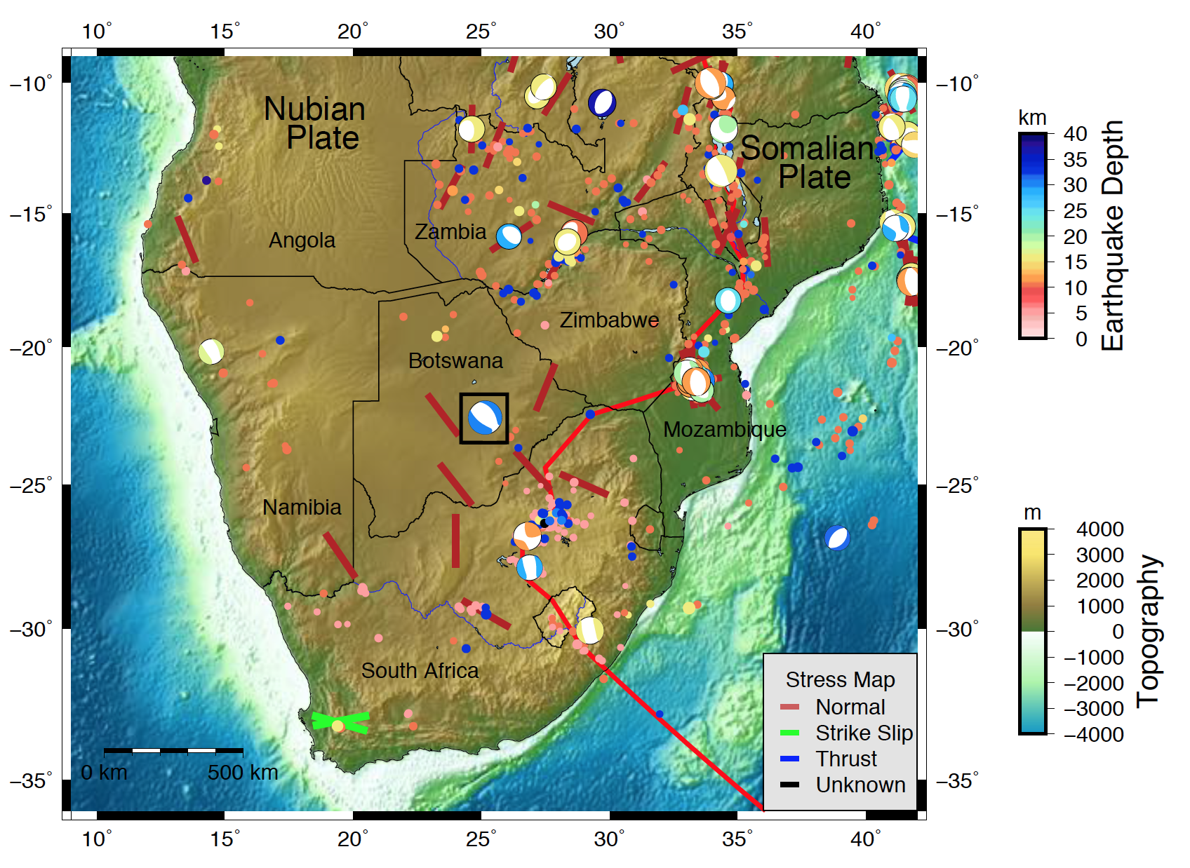
Coseismic deformation of the M6.5 Moijabana, Botswana earthquake
On April 3, 2017, an unusual normal-faulting earthquake occurred in a region of Botswana with no known active faults and little historic seismicity. In order to learn more about the causative fault, we study the event's source characteristics from a joint inversion of Sentinel-1B radar images and teleseismic body waves. We find that joint inversion provides stronger constraints on source geometry than the InSAR inversion alone. It is important to study intraplate events such as this one, as they provide rare opportunities to understand how deformation occurs at slow rates away from plate boundaries.
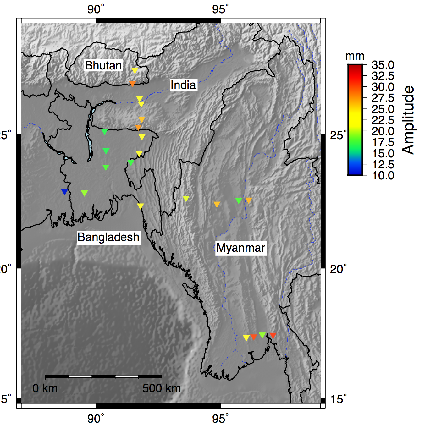
Hydrological Loading in Myanmar and Southeast Asia
In this project, a collaboration with researchers at the Earth Observatory of Singapore, we investigate several GPS measurements in Myanmar, India, Bangladesh, and Bhutan. In particular, we focus on the vertical GPS positions and the annual signals that dominate vertical timeseries. We produce a time-dependent model of elastic hydrological loading from GRACE gravity measurements, and compare with the observed GPS. These types of corrections can be used to reduce the scatter in the vertical measurements, improving our ability to detect tectonic signals.
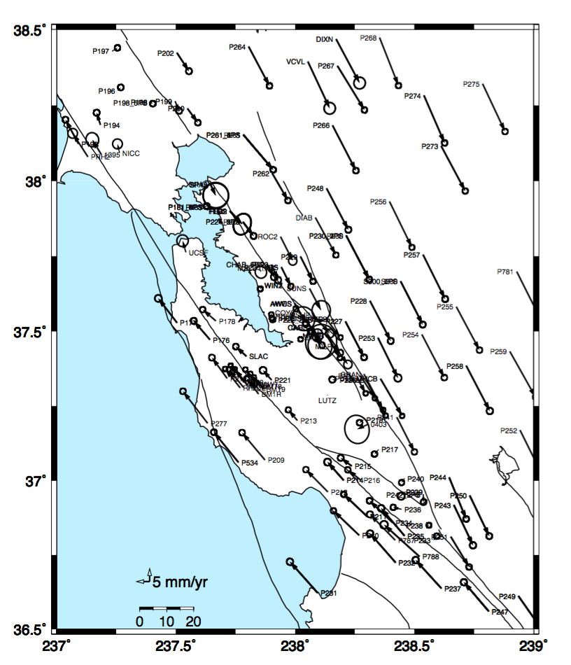
Bay Area Velocity Unification (BAVU) Project
The Bay Area Velocity Unification (BAVU) project is a long-term effort to create an interseismic velocity field using a combination of continuous and campaign GPS data. This project also provides a useful processing framework for a variety of smaller-scale survey efforts in the Bay Area. Most recently, we have used BAVU in targeted surveys on the Peninsula section of the San Andreas Fault and on the southern Calaveras Fault.
The project is currently in its fourth iteration (BAVU4). The BAVU4 velocity field is available by email request.