Seismo Blog
M 4.0 Near Alamo, CA
Categories: CISN Special Report | California Seismicity
September 5, 2008
| Information from the CISN Northern California Management Center USGS & UC Berkeley |
|
| Date & Time (Local): | 09/05/2008 09:00:15 (PST) |
| Date & Time (UTC): | 09/06/2008 04:00:15 (UTC) |
| Location: | 2 mile ENE of Alamo, CA 37.866N 121.996W |
| Depth (km): | 16.2 |
| Magnitude: | 4.0 Mw |
Details
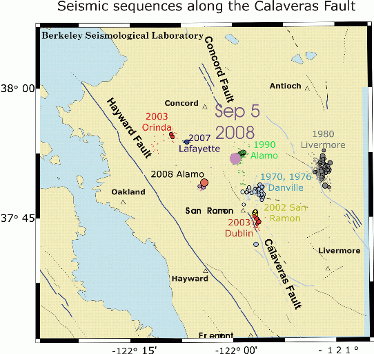
The focus of the earthquake which was widely felt in the Bay Area shortly after 9 pm on Friday night was located about 10 miles below Alamo (large purple circle). Among seismologists this upscale East Bay community is known as a frequent source of temblors. Located along the Calaveras Fault, which roughly parallels Interstate 680, Alamo hosts a type of earthquake which is rather unique for the Bay Area. Over the decades several intense earthquake swarms occurred in this area, the last one in 1990 (green circles). One of the characteristics of swarm earthquakes is that they are not dominated by one main shock and dozens of aftershocks. Instead an earthquake swarm consists of hundreds of similar temblors, which can continue to shake an area over weeks or even months. Friday's quake with its magnitude of 4.0 appears not to be part of a swarm. Only a few small aftershocks have occurred since then. The 9 pm quake was the strongest temblor in the Bay Area since the earthquake sequence at Alum Rock near San Jose in the Fall of 2007.
Peggy Hellweg
- Faulting mechanism: Moment Tensor solution
- List of all earthquakes in the RecentEQs quad (last 7 days)
Ground Motions
The CISN Northern California Management Center produces ShakeMaps for events of M3.5 and higher. ShakeMaps are based on the observed ground motions from seismic instruments combined with predicted motions in areas without sensors.
The CISN Engineering Data Center produces reports showing details of ground motions for events of interest. They have issued an Internet Data Report for the M4.0 showing records from several East Bay sites of interest:
This earthquake was widely felt in the East Bay. People with Internet access can report their observations of shaking and damage through the Did You Feel It? Web site.Unlike the ShakeMaps - which are based on data from seismic instruments - these maps are based on human observations. You can contribute to these data by filling out the form for the event.
BSL Blogging Team: Who we are
Recent Posts
-
: Alerts for the Whole West Coast
-
: Destruction in the Eastern Aegean Sea
-
: An Explosion in Beirut heard all over the Middle East
View Posts By Location
Categories
- Alaska (3)
- Bay Area (24)
- Buildings (3)
- Calaveras (4)
- California (13)
- California ShakeOut (3)
- Central California (4)
- Chile (4)
- Earthquake Early Warning (10)
- Earthquake Faults and Faulting (44)
- Earthquake Science (3)
- Haiti (3)
- Hayward (12)
- Indonesia (4)
- Induced Seismicity (3)
- Instrumentation (18)
- Italy (6)
- Japan (7)
- MOBB (3)
- Mendocino Triple Junction (5)
- Mexico (7)
- Nepal (3)
- North Korea (5)
- Nuclear Test (5)
- Ocean Bottom Seismometer (3)
- Oklahoma (4)
- Plate Tectonics (18)
- Preparedness, Risks, and Hazards (16)
- Salton Sea (3)
- San Andreas Fault (14)
- Seismic Waves (13)
- Seismograms (4)
- ShakeAlert (3)
- Southern California (5)
- Surface Waves (3)
- Today in Earthquake History (20)
- Volcanoes (4)
- subduction (3)