Seismo Blog
The Yosemite Rock Fall of July 10, 1996
Categories: Seismic Sources | Natural Hazards
July 10, 1996
December 10th, 1996
| General Information: | ||
| Region: | Happy Isles Area of Yosemite Valley | |
| Event: | First | Second |
| Date: | 96/07/11 | 96/07/11 |
| Impact Time (UT): | 01:52:28.0 | 01:52:41.6 |
| Latitude: | 37.729 | 37.729 |
| Longitude: | -119.561 | -119.561 |
| ML: | ~1.55 | 2.15+/-0.028 |
At 6:52 pm PDT Wednesday, July 10, 1996, a large block of granite, with an estimated volume of 78,000 cubic yards, detached from the cliff between Washburn Point and Glacier Point, in Yosemite Valley.
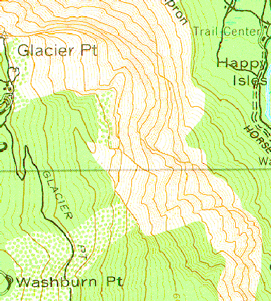
Contour map of Happy Isles area of Yosemite Valley.
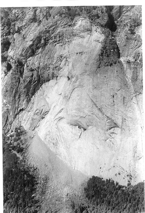
Picture of the cliff between Glacier point and Washburn Point taken the day after the rockfall (photograph courtesy of Gerald Wieczorek).

Picture of the detachment zone. A through D show, in time order, the sequence and falling direction of the largest rock sections. B caused the air blast. Information and photograph courtesy of the Yosemite Association. Photo by Doug Roe, NPS.
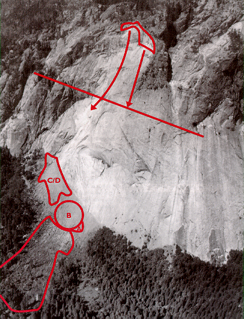
Picture of rockfall showing the detachment zone at the top and the impact area at the bottom. A through D indicate the impact area of each part of the falling rock. The approximately 10 acre area of air blast damage is also outlined. The straight line along the cliff indicates the maximum extent of the Tioga glaciation and the approximate boundary between the sliding and ballistic trajectories of the falling rock. Information and photograph courtesy of the Yosemite Association. Photo by Keith Walklet.
After detaching from the cliff, the rock mass slide down a rock shelf for 600 feet at an angle of 50 degrees from vertical and acquired sufficient speed to free-fall ballistically an estimated 1800 feet (550 m) prior to impacting about 200 feet (60 m) from the base of the cliff in the Happy Isles area of the valley floor in Yosemite National Park (field investigation with Gerald Wieczorak and Richard Waitt).
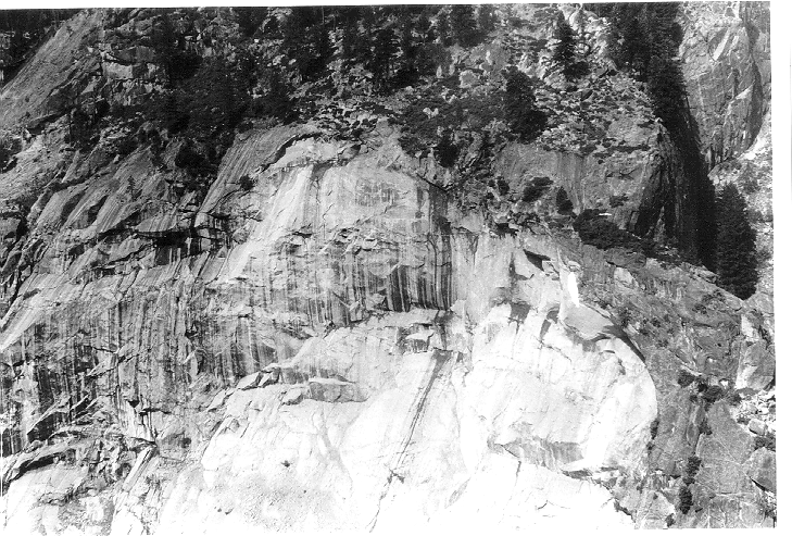
Aerial view of the detachment zone (photograph courtesy of Gerald Wieczorek).
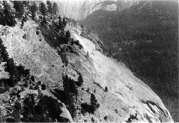
Aerial view of the rock shelf (photograph courtesy of Gerald Wieczorek).
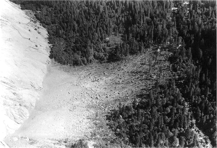
Aerial view of the impact zone and the blast zone where a wind blast created by the rock fall blew over trees between the cliff face and the Happy Isles Nature Center (photograph courtesy of Gerald Wieczorek).
Rock falls are a natural consequence of the continuous exfoliation processes occurring on the granite cliffs in Yosemite Valley. However, most of the time the exfoliation processes result in rock slides and ballistic rock free-falls are rare. This rock fall was well recorded by 3 UC Berkeley (BDSN) and Caltech (TERRAscope) broadband seismographic stations and 15 short period seismographic stations (operated by the USGS in Menlo Park and the University of Nevada, Reno). In fact, it is the largest vertical rock free-fall ever recorded seismically and it registered on seismographs up to 200 km away.
The estimated granite rock mass which fell is 80,000 tons. Ballistic calculations show that the rock impacted on the talus slope at the base of the cliff with a velocity of approximately 117 m/s (260 mph). The component of the rock's velocity tangential to the slope at impact was 78 m/s or 174 mph. It is this 174 mph wind blast which blew over the trees.
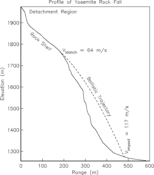
Profile of the cliff showing the trajectory of the rock fall. In order to clear the lower 550 meters of cliff and impact on the talus slope, the rock had to acquire a velocity of 64 m/s (143 mph) while sliding down the rock shelf.
An equivalent local (Richter) magnitude (ML) of 2.15+/-0.028, for the largest impact, was determined from Wood-Anderson seismograms synthesized from broadband recordings at the three closest broadband stations:
| Station | Delta (km) | Azimuth | ML | dML | Network |
| CMB | 80.1 | 295.4 | 2.195 | +0.24 | BDSN |
| KCC | 49.9 | 154.4 | 2.12 | +0.39 | BDSN |
| MLAC | 69.4 | 99.5 | 2.14 | -0.2 | TERRAscope |
where: a dML of -0.2 for MLAC, appropriate for a soft alluvial site, was assumed.
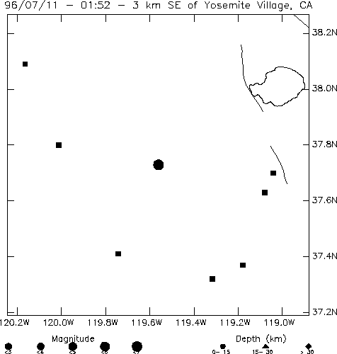
This map, centered on the impact site, shows the locations of the stations, located within 50 km, which were used in the analysis. The epicenter, inferred from phase onset times, does not differ significantly from the impact coordinates (the uncertainty in the solution is +/- 1.5 km).
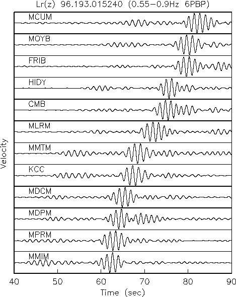
This figure shows vertical component seismograms recorded at the 12 closest stations and band-pass filtered from 0.55 Hz to 0.90 Hz to emphasize the Rayleigh (Lr) waves generated by the rock impact. The stations are arranged in order of increasing distance from bottom to top. Note that there are two envelop maxima in the recorded waveforms approximately 13.6 seconds apart, with the amplitude of the second maxima approximately four times the amplitude of the first maxima.
The implication is that there were two prominent rock impacts, 13.6 seconds apart and that the second one contained about 80 percent of the total rock mass.
Scaling the amplitudes, we infer that the equivalent ML for the first impact is 0.6 units smaller or approximately ML 1.55. The apparent phase velocity of the Lr(z) Rayleigh wave is 2.94+/-0.114 km/s.
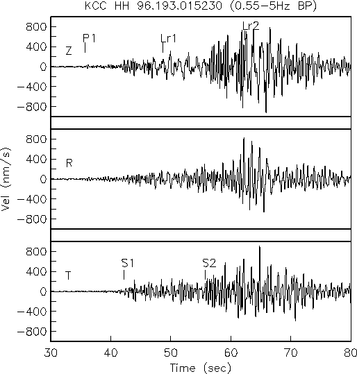
This figure shows the broadband recordings from the Berkeley Digital Seismic Network (BDSN) station KCC, located in a granite tunnel 49.9 km SE of the Happy Isles impact site. The records have been band-pass filtered, from 0.55 Hz to 5.0 Hz (the dominant frequency band excited by the rock fall) and the horizontal components have been rotated to radial and transverse. The prominent phases recorded on this record are also consistent with two impact events separated in time by 13.6 seconds:
| Phase | Onset Time (sec) |
| P1 | 35.7 |
| S1 | 42.2 |
| Lr1 | 48.7 |
| S2 | 55.7 |
| Lr2 | 62.3 |
where: 1 and 2 refer to the impact number. The seismic waves generated by the respective detachments are not apparent in the record, the first is below the ambient noise level and the second is obscured by the seismic waves generated by the first impact. From the observed arrival times of the two Lr(z) phases and the measured Lr(z) velocity of 2.94 km/s, we infer that the times of the impacts were 01:52:28.0 UT and 01:52:41.6 UT, respectively.
Contributed by Robert Uhrhammer. Last updated December 10, 1996.
BSL Blogging Team: Who we are
Recent Posts
-
: Alerts for the Whole West Coast
-
: Destruction in the Eastern Aegean Sea
-
: An Explosion in Beirut heard all over the Middle East
View Posts By Location
Categories
- Alaska (3)
- Bay Area (24)
- Buildings (3)
- Calaveras (4)
- California (13)
- California ShakeOut (3)
- Central California (4)
- Chile (4)
- Earthquake Early Warning (10)
- Earthquake Faults and Faulting (44)
- Earthquake Science (3)
- Haiti (3)
- Hayward (12)
- Indonesia (4)
- Induced Seismicity (3)
- Instrumentation (18)
- Italy (6)
- Japan (7)
- MOBB (3)
- Mendocino Triple Junction (5)
- Mexico (7)
- Nepal (3)
- North Korea (5)
- Nuclear Test (5)
- Ocean Bottom Seismometer (3)
- Oklahoma (4)
- Plate Tectonics (18)
- Preparedness, Risks, and Hazards (16)
- Salton Sea (3)
- San Andreas Fault (14)
- Seismic Waves (13)
- Seismograms (4)
- ShakeAlert (3)
- Southern California (5)
- Surface Waves (3)
- Today in Earthquake History (20)
- Volcanoes (4)
- subduction (3)