Seismo Blog
Waves as Fast As A Jet Plane
Categories: Japan
March 14, 2011
The worst damage in Friday's disaster in Japan was not caused by the shaking of the seismic waves themselves, but by the tsunami. Geologic research on sand layers along the coast of northeastern Honshu has shown that the low lying areas in the prefectures of Miyagi and Fukushima have been inundated by huge tidal waves every thousand years or so. Before Friday, the last such tsunami hit the area in 869 AD. It was caused by the Jogan earthquake, which ruptured roughly the same offshore area as Friday's quake. According to historic documents, more than a thousand people perished when the tsunami washed ashore in the plains of Sendai, and the area which is now occupied by the Fukushima Daiichi nuclear plant.
Although Japan has one of the most sophisticated tsunami warning networks in the world, the coastal region around Sendai is just too close to the quake's epicenter to allow a timely warning. Even though the wave heights were forecast correctly, at more than 30 feet, the arrival of the warning was not early enough for the many inhabitants of the area to take action and flee to high ground. For the rest of Japan's Pacific coast, however, the tsunami warning was very effective.
This is also true for the warning for the whole ocean region, which was issued by the Pacific Tsunami Warning Center (PTWC) in Hawaii. Its scientists issued the first bulletin only nine minutes after the quake. It was not very specific, but stated that the earthquake was strong enough to be able to cause a tsunami. About 15 minutes later, the computers at PTWC had run the first tsunami model for the entire Pacific and the center issued a more detailed warning. It included the arrival times of the tidal wave at coastal towns in many countries and the expected wave heights. The model was updated as more data arrived at PTWC.
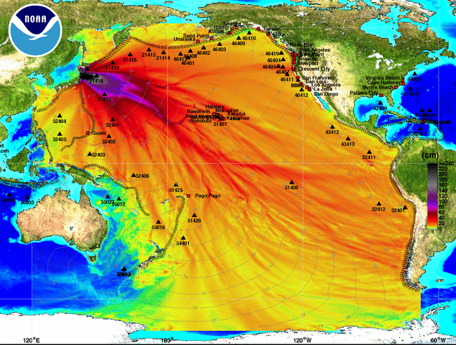
A tsunami travels across an ocean at about the speed of a jetliner. Thus, the wave hit the harbor town of Petropavlosk on Russia's Kamchatka Peninsula in about two hours. Five hours later, the wave arrived in Hawaii, causing minor flooding in Hilo. At around 8 am PST on Saturday morning, the tsunami reached California, causing considerable damage in the harbors of Crescent City and Santa Cruz. (See this video by a local TV station.) Finally, thirteen hours after the earthquake, the wave was registered in New Zealand. Traveling at an average speed of 495 miles per hour, it took 21 hours for the tsunami waves to reach the southern Pacific coastal region of Chile, which was devastated by an earthquake in February 2010. That event had a magnitude of 8.8 and was comparable in size to Friday's quake off the coast of Honshu (see blog March 1, 2010).

This map shows the model calculations for Friday's tsunami. The travel times are represented by the faint blue lines. The colors show the wave heights, from more than 30 feet (dark blue and purple) to less than 1 foot (yellow and green). The model agreed very well with the actual measurements. (Source: Noaa, Click to view larger image.)
The PTWC was established in 1949 after Hawaii suffered major damage from a tsunami caused by an earthquake in Alaska. At first, it issued warnings only for Hawaii, Alaska and the US West Coast. After the giant Chile earthquake of 1960, an intergovernmental agreement extended the PTWC's responsibilities to the entire Pacific basin. During its early years PTWC relied only on seismic measurements. Later, data from tidal gauges began to be used, and after the Indian Ocean tsunami in 2004, many deep sea observatories were added. These sensors are connected by cable to buoys at the ocean's surface, from which data are sent by satellite links to the center's main building near Honolulu. PTWC is operated by NOAA. (hra062)
BSL Blogging Team: Who we are
Recent Posts
-
: Alerts for the Whole West Coast
-
: Destruction in the Eastern Aegean Sea
-
: An Explosion in Beirut heard all over the Middle East
View Posts By Location
Categories
- Alaska (3)
- Bay Area (24)
- Buildings (3)
- Calaveras (4)
- California (13)
- California ShakeOut (3)
- Central California (4)
- Chile (4)
- Earthquake Early Warning (10)
- Earthquake Faults and Faulting (44)
- Earthquake Science (3)
- Haiti (3)
- Hayward (12)
- Indonesia (4)
- Induced Seismicity (3)
- Instrumentation (18)
- Italy (6)
- Japan (7)
- MOBB (3)
- Mendocino Triple Junction (5)
- Mexico (7)
- Nepal (3)
- North Korea (5)
- Nuclear Test (5)
- Ocean Bottom Seismometer (3)
- Oklahoma (4)
- Plate Tectonics (18)
- Preparedness, Risks, and Hazards (16)
- Salton Sea (3)
- San Andreas Fault (14)
- Seismic Waves (13)
- Seismograms (4)
- ShakeAlert (3)
- Southern California (5)
- Surface Waves (3)
- Today in Earthquake History (20)
- Volcanoes (4)
- subduction (3)